• Welcome to TalkWeather!
    We see you lurking around TalkWeather! Take the extra step and join us today to view attachments, see less ads and maybe even join the discussion.
    CLICK TO JOIN TALKWEATHER

Severe Threat May 15-16, 2025

Mesoscale Discussion 0819
NWS Storm Prediction Center Norman OK
0310 PM CDT Fri May 16 2025

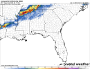
Areas affected...much of northeast Texas into much of southern
Arkansas

Concerning...Severe potential...Watch likely

Valid 162010Z - 162215Z

Probability of Watch Issuance...80 percent

SUMMARY...Scattered severe storms appear likely later this
afternoon, with large hail and locally damaging gusts the most
likely threats.

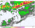
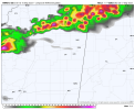
DISCUSSION...The primary surface front currently extends from near
Ft. Smith AR southwestward into parts of North Texas, with very
strong instability in place. A special 19Z FWD sounding shows MLCAPE
of 3250 J/kg, along with 0-6 km shear around 55 kt.

Weak convergence along the front and continued heating should result
in sporadic storm development along this boundary, and the
environment will supercells producing very large hail. Visible
imagery shows towering CU along portions of the front, and
initiation appears likely in the next couple hours.

1747428307672.png
 
To add what @Clancy said, the 19z HRRR, 18z 3km NAM, and 18z RRFS all have a severe line of storms moving thru North MS between midnight thru 1am.
 

Attachments

  • nam-nest-starkville-refc-7461600.png 1am Saturday.png
    nam-nest-starkville-refc-7461600.png 1am Saturday.png
    127.9 KB · Views: 0
  • hrrr-starkville-refc-7461600.png 1am Saturday.png
    hrrr-starkville-refc-7461600.png 1am Saturday.png
    88.4 KB · Views: 0
  • refcmp.us_se.png 12am Saturday.png
    refcmp.us_se.png 12am Saturday.png
    290.1 KB · Views: 0
Some strong SRH is in place over those cells in Missouri. It will expand eastward with time, potentially leading to the focus for strong tornado risk to evolve over parts of Illinois, Kentucky and Indiana. Structural evolution will be important to watch - how many storms remain discrete, and whether or not cells can persist out ahead of a probable QLCS later this evening will influence chances for strong tornadoes.
1747428513223.png
 
Back
Top