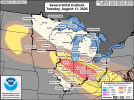
also yeah Illinois didn't go at all. Temperature inversion and leftover MCS tampered the environment significantly. However this means implications for our MCS tmrw. We won't really know the true intensity of our MCS until it comes around but a long lived MCS with 80-100 mph winds at times is looking like a possibility. A isolated tornado or two is possible too.
DAKOTAS
A mesoscale regime will set up the potential for supercells as a secondary target zone for tomorrow in South Dakota. While damaging winds/large hail will likely be the main hazards, i see classic signs of a potentially mesoscale, "sneaky" photogenic tornado tomorrow.
@N0mz will know what I mean.
I made a thread regarding surprise mesoscale environments for tornadoes such like Dickens last year, Bonesteel, Dixon, and any other big boundary tornado you can remember and how they work. Tomorrow's environment features
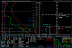
25+ 0-1km SRW - We will likely need some sort of subtle nudging process tomorrow.
SOME vertical low level stretching - 3CAPE, we know what this does. Favorably stretches into the updraft.
Large scale vertical instability - upwards of 2,500 MLCAPE bordering on 3k. These cases need large vertical instability to work.
Relatively weak MnWind - the storm may be able to meander on its own at times, leading to the mesoscale processes that make these tornadoes.
While low level hodographs do not exhibit much lower level SRH, note the VERY GOOD veering with height on this hodograph.
Subtle low level streamwise vorticity - It's there
SE moving storms - these are most notorious for mesoscale surprises
Fail mode - TD spread MAY be too borderline, 20-22. This is purely a test of all these knowledge we know about these environments. And tomorrow is a very good candidate for such. We shall see if it verifies in a open field.
View attachment 54618
SW SD has stronger low level shear but per low level thermos. Either way, i expect a mixed bag of all hazards up here including my sneaky photogenic tornado shot in the dark.