• Welcome to TalkWeather!
    We see you lurking around TalkWeather! Take the extra step and join us today to view attachments, see less ads and maybe even join the discussion.
    CLICK TO JOIN TALKWEATHER

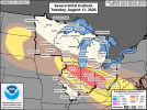
Severe Threat 8/10-13

Looking like a few active days ahead of severe weather. Keeping the title of this thread general and non-region specific for now. Most of the threat today, as others have hinted resides in portions of Wisconsin, Illinois into Indiana.
Thank you for the thread. There's the usual suspects who make them and they've been on the low recently.

Low level stretching could be a big wildcard for any tornadoes in N IL. Extreme vertical instability with nudgers too. Also watching mini spinners in Ontario/New York
 
Seems like today is a pretty decent mesoscale day across two separate regions of the US. Surprised they didn't go with CIG1 for the 2% risks, but with this year being as it is I understand their reluctance to do so.
 

Yeah, serious issue in the Mid Atlantic. They get too trigger happy and decide to warn these storms for no reason despite them not having rotation. Making a city panic unnecessarily is not something a NWS office wants to do. It's in my opinion, negligence to do such. There's no excuses when this has been a consistent pattern of warning outflow dominant QLCSes and it seems this office doesn't even check terminals half the time. It's extremely odd.
 
I'll also like to point out we mightve had a unwarned tornado in Dundalk, MD 10 minutes after both Baltimore warnings expired.


I say mightve to be cautious but if this is in fact determined to be a tornado, I think this office needs serious calling out. This circulation was very evident on the terminal
 
Also quick criteria: I'll argue that Max sarcastically mocking the office in his other tweet and Evan Fryberger calling them flat out idiots too doesn't help public trust either. If you want to give criticism to a office, be real with them and don't make a lunatic out of them. Stupid behavior from both, especially Max as the 2nd biggest following on YouTube, and Evan especially as the guy that doesn't like to start "drama" and keeps it "real" and all of the above. Public trust is improved when a office learns from their mistakes, and is given the criticism in a fair explanation

Anyways, a storm has fired in NE IL. Tornado threat should rely on extreme low level stretching, imo, any nudgers in this environment could hurt a storm too much.
 
I'll also like to point out we mightve had a unwarned tornado in Dundalk, MD 10 minutes after both Baltimore warnings expired.


I say mightve to be cautious but if this is in fact determined to be a tornado, I think this office needs serious calling out. This circulation was very evident on the terminal

This was confirmed now to be a unwarned tornado. Messing up on the actual tornado and choosing to warn outflow slop is just showing this office has a serious lack of radar training/and inexperience. What these young trainees are being taught are not helping them warn things accurately.
 
also yeah Illinois didn't go at all. Temperature inversion and leftover MCS tampered the environment significantly. However this means implications for our MCS tmrw. We won't really know the true intensity of our MCS until it comes around but a long lived MCS with 80-100 mph winds at times is looking like a possibility. A isolated tornado or two is possible too.

DAKOTAS
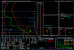
A mesoscale regime will set up the potential for supercells as a secondary target zone for tomorrow in South Dakota. While damaging winds/large hail will likely be the main hazards, i see classic signs of a potentially mesoscale, "sneaky" photogenic tornado tomorrow. @N0mz will know what I mean.

I made a thread regarding surprise mesoscale environments for tornadoes such like Dickens last year, Bonesteel, Dixon, and any other big boundary tornado you can remember and how they work. Tomorrow's environment features

25+ 0-1km SRW - We will likely need some sort of subtle nudging process tomorrow.
SOME vertical low level stretching - 3CAPE, we know what this does. Favorably stretches into the updraft.
Large scale vertical instability - upwards of 2,500 MLCAPE bordering on 3k. These cases need large vertical instability to work.

Relatively weak MnWind - the storm may be able to meander on its own at times, leading to the mesoscale processes that make these tornadoes.
While low level hodographs do not exhibit much lower level SRH, note the VERY GOOD veering with height on this hodograph.
Subtle low level streamwise vorticity - It's there
SE moving storms - these are most notorious for mesoscale surprises
Fail mode - TD spread MAY be too borderline, 20-22. This is purely a test of all these knowledge we know about these environments. And tomorrow is a very good candidate for such. We shall see if it verifies in a open field.

hrrr_2026081100_024_45.00--102.36.png
SW SD has stronger low level shear but per low level thermos. Either way, i expect a mixed bag of all hazards up here including my sneaky photogenic tornado shot in the dark.
 
also yeah Illinois didn't go at all. Temperature inversion and leftover MCS tampered the environment significantly. However this means implications for our MCS tmrw. We won't really know the true intensity of our MCS until it comes around but a long lived MCS with 80-100 mph winds at times is looking like a possibility. A isolated tornado or two is possible too.

DAKOTAS
A mesoscale regime will set up the potential for supercells as a secondary target zone for tomorrow in South Dakota. While damaging winds/large hail will likely be the main hazards, i see classic signs of a potentially mesoscale, "sneaky" photogenic tornado tomorrow. @N0mz will know what I mean.

I made a thread regarding surprise mesoscale environments for tornadoes such like Dickens last year, Bonesteel, Dixon, and any other big boundary tornado you can remember and how they work. Tomorrow's environment features

25+ 0-1km SRW - We will likely need some sort of subtle nudging process tomorrow.
SOME vertical low level stretching - 3CAPE, we know what this does. Favorably stretches into the updraft.
Large scale vertical instability - upwards of 2,500 MLCAPE bordering on 3k. These cases need large vertical instability to work.

Relatively weak MnWind - the storm may be able to meander on its own at times, leading to the mesoscale processes that make these tornadoes.
While low level hodographs do not exhibit much lower level SRH, note the VERY GOOD veering with height on this hodograph.
Subtle low level streamwise vorticity - It's there
SE moving storms - these are most notorious for mesoscale surprises
Fail mode - TD spread MAY be too borderline, 20-22. This is purely a test of all these knowledge we know about these environments. And tomorrow is a very good candidate for such. We shall see if it verifies in a open field.

View attachment 54618
SW SD has stronger low level shear but per low level thermos. Either way, i expect a mixed bag of all hazards up here including my sneaky photogenic tornado shot in the dark.
Yeah, I just can't get behind 86/64. Don't really see how that'll get surface-based.
 
Back
Top