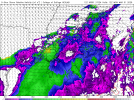
Latest results of my WRF-ARW model. Centered on Memphis, TN. Uses GFS initial conditions from 18z yesterday (I pulled the data before the 0z was out). It is 3 km high resolution and covers about an 1100 mile square area. It goes out only 36 hours (to 06z tomorrow morning), but I'll have another run for tomorrow ready later today.
A *very* short period of discrete activity across AR/MO/TN/KY junction rapidly develops into a linear system overnight. Here it is at 06z tomorrow morning.

The SBCAPE is very high for overnight/morning activity (over 2k). Not sure why the edges on this one are clipped *shrug*

The instantaneous UH is shown below. Notice several spots of moderate rotation in MS, and a large swath of high rotation in eastern Kentucky,

Another look at the radar, but with the Threat Overlay algorithm plotted This is again at 06Z tomorrow morning. The algorithm (despite the rotation aloft in MS and KY) only detects threats of Limited Large Hail potential in Louisiana. (Not sure I buy this, but we'll see.)

I will be running a new model run shortly probably using the 12z runs as initial conditions and will probably center it on MS/AL/GA to get the picture for tonight and Monday a bit better.
(And I gotta check on why images are being clipped on the edges, something with my code probably needs updating.)


