Todd
Member
I certainly do not want a severe weather outbreak that could damage property or cause injury or loss of life. Many people in eastern Missouri and eastern Arkansas experienced it not that long ago.
Follow along with the video below to see how to install our site as a web app on your home screen.
Note: This feature may not be available in some browsers.
Id agree, I'm expecting a day 1 moderate as well somewhere in that vicinity.I would argue the way SPC words what I posted above this still warrants a Moderate Risk especially West Tennessee, Arkansas, and North MS area.

Dang that shot is like 3-15 ..
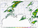
3/14*** MO/ARDang that shot is like 3-15 ..


Are they showing them to be discrete supercells or semi discrete?18Z HRRR really lights up western KY with supercells after dark tomorrow evening, and they keep going for a good 2-3 hours before congealing.
Are they showing them to be discrete supercells or semi discrete?


Let’s hope those two ahead of the cluster don’t take that one path.Mostly semi-discrete although there are one or two depicted running out ahead of the cluster.
Wait so @UncleJuJu98 the event is starting early? OhMesocale Models are really honing in on south Mississippi and South Alabama having an elevated severe threat Sunday morning.
My bad, Monday morning!Wait so @UncleJuJu98 the event is starting early? Oh
If that verifies then a D1 MDT would be totally justified.Dang that shot is like 3-15 ..
Yeah, IF..If that verifies then a D1 MDT would be totally justified.
Check it out in other thread @UpperLevelLOLHmmm, is tonight’s threat in OK uptrending a bit? Seems like the hail threat has expanded a bit at least
")