TH2002
Member
- Messages
- 4,973
- Reaction score
- 11,113
- Location
- California, United States
- Special Affiliations
- SKYWARN® Volunteer
Hopefully so.The CC drop is displaced from the precip, so this likely doesn't tell us much.
Follow along with the video below to see how to install our site as a web app on your home screen.
Note: This feature may not be available in some browsers.
Hopefully so.The CC drop is displaced from the precip, so this likely doesn't tell us much.
As in right through B'ham metro! UGH.Nothing out there to disrupt this Hale/Green county storm. Looking ahead, if it maintains itself, it won't be the classic Tuscaloosa -> Pleasant Grove -> Fultondale track, it'll be a good bit south of there.
Edit: not saying it's goign to put down a 100 mile tornado, or if it'll produce anything at all.
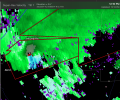
That’s a big boy. It’s going to track for a long time.The TOR warned storm in Hale/Tuscaloosa Counties is really tightening up.
wondering if these will stay discrete enough. they look rather messy at the moment.No expert, but I would suspect these guys might become a problem later?View attachment 7529
still looks like some Sidelobe Contamination but definitely could tighten up in a short period of timeThe TOR warned storm in Hale/Tuscaloosa Counties is really tightening up.

Looks like a Eyewall lolThat hook echo....
View attachment 7531
Really does. That's probably not a good thing.Looks like a Eyewall lol