Kory
Member
This potential tornado will likely take the same track as last week.
Follow along with the video below to see how to install our site as a web app on your home screen.
Note: This feature may not be available in some browsers.
Tornado Warning.

Definitely reminding me a lot of 3/17, lots of rotation on those storms but it seems like the instability just isn't there right now because of the cloud cover.cell getting sus, but i think it’s elevated
Definitely reminding me a lot of 3/17, lots of rotation on those storms but it seems like the instability just isn't there right now because of the cloud cover.
These storms are for sure becoming surface based. Further west, the SLP needs to start deepening because low level shear is rather lousy according to the JAN VAD.Definitely reminding me a lot of 3/17, lots of rotation on those storms but it seems like the instability just isn't there right now because of the cloud cover.

This will be our first tornado on the ground...no doubt.Nothing out there to disrupt this Hale/Green county storm. Looking ahead, if it maintains itself, it won't be the classic Tuscaloosa -> Pleasant Grove -> Fultondale track, it'll be a good bit south of there.
Edit: not saying it's goign to put down a 100 mile tornado, or if it'll produce anything at all.

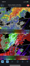
Big time CC drop on the storm NE of Birmingham
View attachment 7528
Big time CC drop on the storm NE of Birmingham
View attachment 7528