• Welcome to TalkWeather!
    We see you lurking around TalkWeather! Take the extra step and join us today to view attachments, see less ads and maybe even join the discussion.
    CLICK TO JOIN TALKWEATHER
Logo 468x120

Severe WX Severe Threat 25 March 2021

MattPetrulli

Member
Messages
420
Reaction score
466
Location
Pigeon Forge, TN
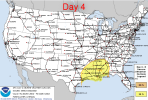
SPC has put out a day 4 risk for 3/25/21
NAM, GFS, Euro all paint some type of significant severe risk however there are some big timing and location differences for Eastern LA through southern AL.
Here's SPC discussion
...DISCUSSION...
...Day 4/Thu - Eastern TX to the Central Gulf Coast States...

An upper shortwave trough over the Rio Grande/northern Mexico will
strengthen and become negatively tilted as it ejects northeast
across the Arklatex through Thursday evening, and to the Ohio Valley
by Friday morning. Intense shear will overspread the south-central
and southern U.S. ahead of the trough. Furthermore, strong low-level
warm advection will result in a broad warm sector ahead of a
deepening surface low and eastward-advancing cold front from the
Sabine Valley eastward across the central Gulf coast/TN Valley
vicinity.

Differences in the evolution of the surface low across the lower MS
and OH Valleys are still apparent in medium-range guidance. This is
mainly resulting in uncertainty in the position of the surface low
and cold front Thursday morning, and how far east each of these
features progresses by Friday morning. As a result, changes in
severe probabilities, especially on the western and northeastern
edges, are likely in the coming days. Nevertheless, weak to moderate
instability will overlap with favorable shear parameters and an
overall supportive pattern for severe convection. A couple of rounds
of severe storms could be possible, as some warm-sector development
may occur across the Lower MS Valley before a QLCS develops along
the surging cold front during the evening/nighttime hours. All
severe hazards will be possible with discrete warm-sector
supercells. Potential for damaging gusts and tornadoes will becoming
preferential with any upscale development along the cold front.
 

Attachments

  • Screenshot 2021-03-22 8.42.37 AM.png
    Screenshot 2021-03-22 8.42.37 AM.png
    182.6 KB · Views: 0

Marshal79344

Member
Messages
361
Reaction score
1,064
Location
Chicago, IL
Currently, the NAM is the outlier with the intensity of the 850 mb jet (using Euro, GFS, UKMET, and GDPS), but all models are in agreement of a rather more unstable than normal Dixie Alley Tornado environment with good wind shear values, higher than those on 3/17 in the OWS (excluding the enhanced streamwise vorticity from the warm front.) Some of these hodographs I've seen look like classic Dixie Alley long-neckers on the radar, but the model agreement has to increase more for an increase in probabilities imo.
 

warneagle

Member
Messages
3,730
Reaction score
3,216
Location
Arlington, VA
Special Affiliations
  1. SKYWARN® Volunteer
Yeah there are certainly some potent wind fields and decent instability, especially in Mississippi, but the globals are still way apart on the positioning of the surface low among other things. The ECMWF still has it back over Arkansas at 00z Friday while the GFS has brought it all the way to the Alabama/Tennessee border. There's also some disagreement on how far north the warm front gets. So, you know, some fairly important details. The potential is definitely there for something substantial (although maybe not quite as widespread as 3/17), but there's still a lot of uncertainty here.
 

Kory

Member
Messages
4,928
Reaction score
2,119
Location
Tuscaloosa, Alabama
Yeah there are certainly some potent wind fields and decent instability, especially in Mississippi, but the globals are still way apart on the positioning of the surface low among other things. The ECMWF still has it back over Arkansas at 00z Friday while the GFS has brought it all the way to the Alabama/Tennessee border. There's also some disagreement on how far north the warm front gets. So, you know, some fairly important details. The potential is definitely there for something substantial (although maybe not quite as widespread as 3/17), but there's still a lot of uncertainty here.
The new GFS (which is now the official op GFS as of 12z) seemingly has convective feedback issues that plagued the old one as well.
 
Messages
2,755
Reaction score
4,297
Location
Madison, WI
Is the NAM overcooking things again or will this coming Thursday be for MS what last Wednesday wasn't?...some of those hodos look gnarly. Dun dun dun! Stay tuned!
 

Kory

Member
Messages
4,928
Reaction score
2,119
Location
Tuscaloosa, Alabama
Is the NAM overcooking things again or will this coming Thursday be for MS what last Wednesday wasn't?...some of those hodos look gnarly. Dun dun dun! Stay tuned!
The forcing is much more subtle so I’m not sure how much of the warm sector actually convects. Throw in potential early morning rain complex that lifts north...I think there will be an enhanced (not using SPC outlook jargon here) region where we get boundary interaction with whatever cellular convection can get going.

And let me tell you...someone is gonna get a boatload of rain as well.
 

warneagle

Member
Messages
3,730
Reaction score
3,216
Location
Arlington, VA
Special Affiliations
  1. SKYWARN® Volunteer
The forcing is much more subtle so I’m not sure how much of the warm sector actually convects. Throw in potential early morning rain complex that lifts north...I think there will be an enhanced (not using SPC outlook jargon here) region where we get boundary interaction with whatever cellular convection can get going.

And let me tell you...someone is gonna get a boatload of rain as well.
PWAT pushing 2" in some places on Thursday evening...yeah...
 

Equus

Member
Messages
3,290
Reaction score
3,368
Location
Jasper, AL
Special Affiliations
  1. SKYWARN® Volunteer
Looks like, at the very least, a raincoat may be the fashion of the day for the latter half of the week.
 

andyhb

Member
Messages
1,035
Reaction score
2,699
Location
Norman, OK
Biggest difference on the kinematic side between Thursday and 3/17 is the presence of a low level jet that falls within the upper end in terms of strength right from 18z. I certainly have some concerns about ongoing convection and the warm front getting stunted thanks to precipitation early, but those warm sector hodographs are pretty threatening and there's certainly plenty of moisture.
 

Kory

Member
Messages
4,928
Reaction score
2,119
Location
Tuscaloosa, Alabama
There are some synoptic similarities with the the Easter event last year...especially with the Euro. Don’t want to roll the dice with something like that again given the completely different background state (La Niña, stronger EMLs, less STJ influence).
 

warneagle

Member
Messages
3,730
Reaction score
3,216
Location
Arlington, VA
Special Affiliations
  1. SKYWARN® Volunteer
Yeah, model-to-model and run-to-run consistency aside, most of the solutions are still potent threads, so I second the motion to pin this.
 
Messages
2,755
Reaction score
4,297
Location
Madison, WI
The extremely sharp instability/STP gradient that the NAM portrays in west Alabama for Thursday is interesting. It looks like any supercells would run into a brick wall and die if they tried to move east of about Lamar/Pickens Counties. Good news for the rest of Alabama if it verifies like that (although it does look like the unstable warm sector tries to shift east some by 03Z Friday), but what could be causing that?
 

Equus

Member
Messages
3,290
Reaction score
3,368
Location
Jasper, AL
Special Affiliations
  1. SKYWARN® Volunteer
NAM solution is indeed brow-raising; given the lack of cap shown however I'd imagine the warm sector will get pretty crowded. Might be another situation like Easter where much of the area gets raked with flooding and embedded severe while a smaller area where there's less junk in the warm sector gets isolated supercells capable of taking advantage of the high end environment.
 
Back
Top