
Navigation
Install the app
How to install the app on iOS
Follow along with the video below to see how to install our site as a web app on your home screen.
Note: This feature may not be available in some browsers.
More options
-
Welcome to TalkWeather! We see you lurking around TalkWeather! Take the extra step and join us today to view attachments, see less ads and maybe even join the discussion. CLICK TO JOIN TALKWEATHER
You are using an out of date browser. It may not display this or other websites correctly.
You should upgrade or use an alternative browser.
You should upgrade or use an alternative browser.

I have some serious doubts the warm sector is going to be this messy in the 18z-00z timeframes as depicted by the 12z Euro.
It's been doing this for several years now. There must be some kind of parameterization that changed in one of the updates. Nothing else does that, not even other models that are the least bullish on the EML/capping.View attachment 6923
I have some serious doubts the warm sector is going to be this messy in the 18z-00z timeframes as depicted by the 12z Euro.
MetFromTheBlue
Member
SREF is pretty against the idea of any convection south of the warm front prior to 18z, and not much of a warm sector signal for precip (at least not across MS/AL) before 21z. So I'm also doubting the ECMWF precip progs.
Last edited:
Marshal79344
Member
I've become really concerned with the increase in flow over MS/AL/TN. While it's not the strongest, it's 100% sufficient enough to favor significant tornadoes, and it also creates very favorable wind profiles for tornadoes in the process. Unlike past Dixie Events, this one is lacking that typical morning convection, and there's some hot instability developing throughout the day, resulting in favorable and efficient updraft profiles, resulting in them being more efficient than usual in taking the wind shear available in the environment and turning it into a tornado. Regardless of cloud cover or not, that strong moisture return is easily sufficient enough to increase the lower-level lapse rates to a sufficient level. I'm thinking of a 4/28/2014 type storm mode, rather messy with several supercells in the mix. Any supercell that becomes well-established will have significant tornado potential. It's going to be a dangerous day.
CheeselandSkies
Member
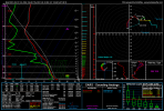
Pulled this forecast sounding from near Boligee, AL. Pops 12/16/00 (day of the first Tuscaloosa F4 that everybody remembers) on the analogs.
Some of these forecast hodos are the most classic I've seen in a long time. Those 850s are ripping, there are some areas where they are veered to southwesterly but a good bit of area where they are nearly straight out of the south. There's some veer-backing up to 700mb depicted in soundings valid for 21Z Wednesday, but that largely diminishes/disappears by 00Z Thursday.
Some of these forecast hodos are the most classic I've seen in a long time. Those 850s are ripping, there are some areas where they are veered to southwesterly but a good bit of area where they are nearly straight out of the south. There's some veer-backing up to 700mb depicted in soundings valid for 21Z Wednesday, but that largely diminishes/disappears by 00Z Thursday.
Attachments
The main reason for 4/28/14's messy storm mode was that deep-layer shear, while adequate for tornadic supercells and big tornadoes, was very marginal for classic structures and more in the HP range. That led to quickly cycling supercells with messy structures and short tracks for most of the tornadoes. Wednesday's deep-layer shear magnitude is woefully different. It is firmly, undeniably, into the range supportive of classic supercell structure and long, fast-moving tracks.I've become really concerned with the increase in flow over MS/AL/TN. While it's not the strongest, it's 100% sufficient enough to favor significant tornadoes, and it also creates very favorable wind profiles for tornadoes in the process. Unlike past Dixie Events, this one is lacking that typical morning convection, and there's some hot instability developing throughout the day, resulting in favorable and efficient updraft profiles, resulting in them being more efficient than usual in taking the wind shear available in the environment and turning it into a tornado. Regardless of cloud cover or not, that strong moisture return is easily sufficient enough to increase the lower-level lapse rates to a sufficient level. I'm thinking of a 4/28/2014 type storm mode, rather messy with several supercells in the mix. Any supercell that becomes well-established will have significant tornado potential. It's going to be a dangerous day.
Recent research has suggested that there is somewhat of a VBV pattern in many of storm-relative hodographs for violent tornado events. Everybody being scared of VBV, especially when it isn't strong VBV, is mostly anecdotal, and recent research is really starting to lean away from that, if not scream against it.Pulled this forecast sounding from near Boligee, AL. Pops 12/16/00 (day of the first Tuscaloosa F4 that everybody remembers) on the analogs.
Some of these forecast hodos are the most classic I've seen in a long time. Those 850s are ripping, there are some areas where they are veered to southwesterly but a good bit of area where they are nearly straight out of the south. There's some veer-backing up to 700mb depicted in soundings valid for 21Z Wednesday, but that largely diminishes/disappears by 00Z Thursday.


That's a composite of 70 F4-F5 cases...
CheeselandSkies
Member
From our own @andyhb , no less.
First sniff of a CAM at this event is the tail end of the 12Z 3KM NAM's run. Only has one major cell in Dixie through 00Z Thursday, but it is a doozy initiating in north-central MS shortly after 21Z and tracking into southwest TN with an intense UH streak.
First sniff of a CAM at this event is the tail end of the 12Z 3KM NAM's run. Only has one major cell in Dixie through 00Z Thursday, but it is a doozy initiating in north-central MS shortly after 21Z and tracking into southwest TN with an intense UH streak.
That is not my research haha, was just forwarding it to a larger audience.
Marshal79344
Member
This has got to be one of the more impressive profiles I've seen in a while...

Equus
Member
Gotta say that's some stout instability for March in a Dixie event. Been used to the low CAPE high shear events lately but this one is a different animal.
- Admin
- #173
- Messages
- 2,433
- Reaction score
- 2,273
- Location
- Meridianville, Al
- Special Affiliations
- SKYWARN® Volunteer
Time sensitive - HUN is doing a Q and A regarding Wednesday's threat
Shakespeare 2016
Member
So this has the potential to produce several EF4 and EF5 tornadoes?Recent research has suggested that there is somewhat of a VBV pattern in many of storm-relative hodographs for violent tornado events. Everybody being scared of VBV, especially when it isn't strong VBV, is mostly anecdotal, and recent research is really starting to lean away from that, if not scream against it.
View attachment 6925
View attachment 6926
That's a composite of 70 F4-F5 cases...
No. I wasn't saying that at all. I was commenting that recent research suggests that the veer-back-veer wind pattern may not be nearly as harmful to tornadoes as originally thought, especially if it's more subtle to moderate.So this has the potential to produce several EF4 and EF5 tornadoes?
CheeselandSkies
Member
No. I wasn't saying that at all. I was commenting that recent research suggests that the veer-back-veer wind pattern may not be nearly as harmful to tornadoes as originally thought, especially if it's more subtle to moderate.
Quite possibly, but a lack of veer-backing (in other words, a classic steadily veering with height wind profile) to me lends greater confidence in a "cleaner" storm mode and associated enhanced threat of high-end tornadoes (not that they are impossible with some veer-backing).
Yeah, I definitely wasn't suggesting that VBV is preferred. It's just looking more possible that it's not nearly as much of a hindrance, or especially a complete killer, as many people think... especially if it's not substantial.Quite possibly, but a lack of veer-backing (in other words, a classic steadily veering with height wind profile) to me lends greater confidence in a "cleaner" storm mode and associated enhanced threat of high-end tornadoes (not that they are impossible with some veer-backing).
Weatherphreak
Member
I'm worried that the warm front coming through in the morning could catch some people off guard. Brad Travis mentioned storms riding the warm front could easily start rotating. Based off this am its still kinda dark around 7am in Huntsville when the storms could be entering the area not to mention the increased rush hour traffic I've noticed since the beginning of the year.
tennessee storm chaser
Member
- Messages
- 1,877
- Reaction score
- 4,288
- Location
- jackson tennessee
- Special Affiliations
- SKYWARN® Volunteer
Fwiw. Kpah Paducah Kentucky nws saying warm front coming through into west Kentucky couple row of counties ... that puts much western mid tennessee warm sector if that is correct ...
Bamamuscle
Member
I know folks hate the comparisons but... The same thing happened on 4/27. I remember they delayed schools because of bad storms that morning.. kids got to school and they released them an hour later. I had to pull over at a Jacks and get in the walk-in cooler with my daughter. Got caught in a bad storm after I picked her up. It was two distinct waves of severe storms before the bad stuff that evening. Not liking this at all.
Sent from my iPhone using Tapatalk