
Seeing debris fallout on CC. That caused damage.
Navigation
Install the app
How to install the app on iOS
Follow along with the video below to see how to install our site as a web app on your home screen.
Note: This feature may not be available in some browsers.
More options
-
Welcome to TalkWeather! We see you lurking around TalkWeather! Take the extra step and join us today to view attachments, see less ads and maybe even join the discussion. CLICK TO JOIN TALKWEATHER
You are using an out of date browser. It may not display this or other websites correctly.
You should upgrade or use an alternative browser.
You should upgrade or use an alternative browser.
Severe WX Severe Threat 12-15 March 2021
- Thread starter warneagle
- Start date
Equus
Member
Seems like every event lately there's something like this long after everything else quiets down, assuming LLJ ramping up
Equus
Member
Here's this in OK too; wouldn't sleep on the threat just yet

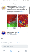
Seeing debris fallout on CC. That caused damage.
NWS Dodge City is denying that it was a tornado. Think they are going to have to eat that denial come daylight
What. How? Like how can you deny that.NWS Dodge City is denying that it was a tornado. Think they are going to have to eat that denial come daylight
What. How? Like how can you deny that.
Don’t know, they weren’t exactly thorough in their explanation.
Attachments
That’s insanely arrogant.Don’t know, they weren’t exactly thorough in their explanation.
That’s insanely arrogant.
I guess they are trying to blame it on the interference from the wind farm that is there? Beats me. There’s pretty clearly debris lofted and carried pretty far north on higher tilts.
OHWX97
Member
Haha what??? Are they serious? What else would it be? That one word response without a single ounce of explanation is totally unprofessional. At least let the public know what the heck we're looking at, because everything about that radar presentation screamed "tornado."Don’t know, they weren’t exactly thorough in their explanation.
WhirlingWx
Member
They're explaining a bit more now (see thread)
It still seems to me like this was a tornado, but I guess we'll have to find out later. Much more appropriate response from them here, though.
It still seems to me like this was a tornado, but I guess we'll have to find out later. Much more appropriate response from them here, though.
OHWX97
Member
They're explaining a bit more now (see thread)
I'm baffled. I'm happy they explained themselves better, but you just don't get velocity signatures like that with an elevated storm.
They're explaining a bit more now (see thread)
It still seems to me like this was a tornado, but I guess we'll have to find out later. Much more appropriate response from them here, though.
...”strong wind gust” LOL. Yeah, it’s called a tornado.
Equus
Member
The recent NC EF3 happened in an environment assumed elevated too, so I'd not want to be quick to assume such, but they're the experts not me. Not sure how we get a CC sig and a brief reflectivity spike there with an elevated cell unless that was a perfectly timed hail shaft
OHWX97
Member
Debris ball on reflectivity: check...”strong wind gust” LOL. Yeah, it’s called a tornado.
Intense couplet on velocity: check
CC drop that lines up with said couplet/debris ball: check
Tornado? "No."
Sorry. I'm a bit bugged by this.
- Moderator
- #155
Yeah that's bizarre. I was thinking "No." "Dangit we missed another one!"
Apparently they're in a bit of damage control now.
In my imagination they've been glued to the radar meticulously analyzing every aspect of every scan for hours on end and someone comes along and says "lol u missed a spot" and they flipped the table.
Either way I'm interested to see what comes of the radar signature without trying to add to any finger pointing.
I'm baffled. I'm happy they explained themselves better, but you just don't get velocity signatures like that with an elevated storm.
There’s a sliver of surface instability just SW of Dodge City, this thing did this crossing the warm front most likely. It might be 48/48 in dodge city, but it was about 60/59 where this tornado occurred, and it was a surface based storm.
I respect the NWS and the vast majority of the Mets that work there, but whoever is in charge at DDC tonight dropped the ball badly, and continues to kick it around to try and save face.
Casuarina Head
Member
Is it possible that large-scale development of wind farms may locally enhance conditions that lead to spin-up tornadoes?
- Admin
- #158
- Messages
- 2,428
- Reaction score
- 2,268
- Location
- Meridianville, Al
- Special Affiliations
- SKYWARN® Volunteer
a chaser from Live Storms Media who also works with KAKE says he does not see obvious evidence of a tornado.
This post immediately before a series of significant tornadoes. I see you haven’t lost your step.Activity is already going upscale and/or quasi-linear. Clearly, the mid-level flow is largely parallel to the boundary, so mergers are already taking place on NEXRAD. Some bowing is also evident with the relatively “discrete” activity thus far. The best parameters for SIGTOR are highly localised and ephemeral at best.
MattW
Member
- Messages
- 387
- Reaction score
- 379
- Location
- Decatur, GA
- HAM Callsign
- KG4GUF
- Special Affiliations
- SKYWARN® Volunteer
I'm inclined to believe the ground truth report. But at the same time, at Ensign, KS, the radar beam is only ~900ft up at that point.