atrainguy
Member
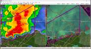
I think we have a TOG west of Gorum, LA
View attachment 22132
edit: yep definitely a tornado
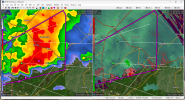
View attachment 22133
Follow along with the video below to see how to install our site as a web app on your home screen.
Note: This feature may not be available in some browsers.
I think we have a TOG west of Gorum, LA
View attachment 22132
edit: yep definitely a tornado
View attachment 22133
This last spring it kicked off a ef4 from a cell merger lol. And I think a cell merger caused a ef2 up near wear jp livesLook at that little kidney bean passing just NW of Alexandria. About to slam into the big, ongoing tornadic storm. Cell mergers can do funky things...
Did anyone else notice that wording has gone from “a strong tornado” to “a few of which could be strong”?Watch coming for eastern LA/parts of MS:
Storm Prediction Center Mesoscale Discussion 2276
Severe weather, tornado, thunderstorm, fire weather, storm report, tornado watch, severe thunderstorm watch, mesoscale discussion, convective outlook products from the Storm Prediction Center.www.spc.noaa.gov


Pardon my ignorance but this (just by itself) looks “meh” to me lolNote to SE AL/W GA folks: 18Z CAMs bringing instability for tomorrow afternoon up into the low-mid hundreds, nearing 1000 j/kg in a few areas. With favorable shear profiles, people should keep a close eye on storms tomorrow if modelled solutions verify.
View attachment 22136View attachment 22137View attachment 22138
Mostly a consequence of color scheme; the gray areas comprise CAPE of 300-900, which would be plenty to sustain severe convection.Pardon my ignorance but this (just by itself) looks “meh” to me lol
It probably won’t be though..
Fair point.Mostly a consequence of color scheme; the gray areas comprise CAPE of 300-900, which would be plenty to sustain severe convection.
I thought so too. Certainly looked like a debris signature appeared on CC as it moved though and east of New Llano. Lined up well with a small, weak couplet.There MIGHT be an unwarned tornado going on near Leesville, LA, right now...