• Welcome to TalkWeather!
    We see you lurking around TalkWeather! Take the extra step and join us today to view attachments, see less ads and maybe even join the discussion.
    CLICK TO JOIN TALKWEATHER

Severe WX Memorial Day 2022 Severe Threat (May 29th - June 2nd)

OHWX97

Member
Messages
1,013
Reaction score
1,425
Location
Maineville, Ohio
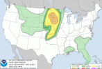
An episode of potentially significant severe weather is expected today and tomorrow for the Northern and Central Plains into the Upper Midwest, spreading into the Southern Plains and deeper into the Midwest on Tuesday, and possibly into Ontario and the Mid-Atlantic states on Wednesday.

There's a risk of significant hail and damaging winds later today (05/29) spanning from central Nebraska into central Minnesota. A few tornadoes will also be possible, but wind and hail appears to be the greatest threat.
day1otlk_1300.gif

Memorial Day (05/30) is particularly concerning for eastern South Dakota, southeastern North Dakota, Minnesota, as well as northern Iowa. I don't want to throw out the "O" word, but if a favorable storm mode develops, a line of supercells capable of strong, long-tracked tornadoes, very large hail, and destructive straight line winds is a real possibility for that area Monday afternoon/evening.
day2otlk_0600.gif

Significant severe weather is again possible on, Tuesday (05/31), particularly from northern Missouri into northern Oklahoma and the Texas Panhandle. All hazards are on the table.
day3otlk_0730.gif

A lingering threat of severe weather is possible on Wednesday (06/01) for the southern Plains and even up into Ontario and much of New York state before things taper off by Thursday.
day4prob.gif
 

OHWX97

Member
Messages
1,013
Reaction score
1,425
Location
Maineville, Ohio
SPC’s wording for Monday seems pretty threatening considering there’s a big 10% hatched risk for strong tornadoes.
A day 2 moderate risk this afternoon wouldn't be surprising.

The tornado risk was upgraded in the latest day 1 outlook. Any supercell that can develop in that area could be problematic.
day1probotlk_1630_torn.gif
 
Last edited:

OHWX97

Member
Messages
1,013
Reaction score
1,425
Location
Maineville, Ohio
The SPC has issued a day 2 moderate risk, specifically for the tornado threat.
day2probotlk_1730_torn.gif
Day 2 Convective Outlook
NWS Storm Prediction Center Norman OK
1229 PM CDT Sun May 29 2022

Valid 301200Z - 311200Z

...THERE IS A MODERATE RISK OF SEVERE THUNDERSTORMS ACROSS PORTIONS
OF WESTERN MINNESOTA...FAR NORTHEAST SOUTH DAKOTA...AND FAR
SOUTHEAST NORTH DAKOTA....

...SUMMARY...
Numerous severe thunderstorms are forecast across parts of the Upper
Midwest with scattered severe storms southward into the central
Great Plains on Monday and Monday night. Large to giant hail, 60-80
mph gusts, and several tornadoes are probable, including the
possibility for a couple of intense long-track tornadoes over parts
of the Upper Midwest.


...Synopsis...
A strong mid-level jet streak will round the base of the larger
scale trough across the western CONUS and strengthen to near 100
knots as the upper-level low amplifies across the northern Plains.
Meanwhile, a surface low will deepen as it moves from the central
Plains into the Upper Midwest. As this occurs, low-level flow will
strengthen and the cold front will sharpen across eastern
Nebraska/southeast South Dakota as it moves northeastward.

...Upper Midwest...
Several clusters of thunderstorms will likely be ongoing at the
beginning of the period across eastern South Dakota/Minnesota. This
will likely have some implications on the location of the greatest
severe weather threat during the afternoon/evening, with hints of
remnant outflow boundaries in some 12Z CAM guidance. Regardless of
morning convective coverage, significant mass response associated
with the deepening surface low should support airmass recovery
across a majority of the warm sector. In fact, RAP forecast
soundings indicate temperatures only need to warm into the mid 70s
to erode inhibition near the surface low and upper 70s farther east
in the warm sector. This could happen as early as 15-16Z across
southeast South Dakota in a strongly sheared wind profile supportive
of supercells and all severe weather hazards.


Strong instability is expected across central/western Minnesota
where the HREF mean MLCAPE exceeds 2000 J/kg across a broad region
where effective shear will be in excess of 70 knots. Therefore,
numerous supercells are expected to develop along and ahead of the
cold front as it moves northeastward through the afternoon. Surface
winds are forecast to remain southeasterly east/northeast of the
surface low as it deepens through the afternoon. These backed
surface winds combined with a 35-40 knot low-level jet
(strengthening to 50 knots by 00Z) will provide ample low-level
shear supportive of strong tornadoes. Additionally, the deep-layer
shear vector orientation will support discrete or semi-discrete
storm mode which will also increase tornado potential.
There may be
too much forcing and storm interaction across eastern South Dakota
and North Dakota which could have a detrimental impact on tornado
potential, but a more discrete mode is expected with eastward
expanse. Therefore, a moderate risk has been added for the region
which is most likely to have the greatest storm coverage that
remains discrete enough for a significant tornado threat. The
ambient environment (2000+ J/kg MLCAPE) and 70+ knots of effective
shear with strong low-level shear could support long-lived/intense
tornadoes with any supercells which can remain discrete for an
extended period of time.


...Central Plains...
Farther south along the front, more isolated thunderstorm
development is expected with more veered low-level flow. Enough
mid-level flow is expected to overlap the warm sector to provide
ample shear for storm organization in a very unstable environment.
Therefore, supercells will be the primary storm mode with any
development along the front.

Isolated to scattered convection is anticipated across portions of
Iowa/eastern Nebraska and potentially into northeast Kansas with a
more conditional threat to the south. CAM guidance tries to hint at
some convective attempts along the dryline as far south as I-40 in
Oklahoma, but rising heights and warm mid-level temperatures will
likely limit storm potential that far south. However, an isolated
threat persists into southern Kansas and perhaps northern Oklahoma.

..Bentley.. 05/29/2022
 
Messages
2,755
Reaction score
4,295
Location
Madison, WI
Based on CAM solutions thus far, it looks like southwest to south-central Minnesota (southern fringe of the 10 hatched) might be a little better play for discrete activity (this is also probably my laziness/gas money bias, since it's not quite as far of a drive for me as west-central MN).
 

OHWX97

Member
Messages
1,013
Reaction score
1,425
Location
Maineville, Ohio
In the middle of the night, a powerful QLCS plowed through Sioux Falls, SD, moving eastward into parts of northern Iowa and Minnesota, producing widespread wind damage and possibly several tornadoes. An ominous and foreboding start to the day.

SPC's Day 1 convective outlook specifically mentions an outbreak of severe storms and tornadoes is likely later this afternoon/evening.
day1probotlk_1200_torn.gif
day1probotlk_1200_wind.gif
Day 1 Convective Outlook
NWS Storm Prediction Center Norman OK
1244 AM CDT Mon May 30 2022

Valid 301200Z - 311200Z

...THERE IS A MODERATE RISK OF SEVERE THUNDERSTORMS ACROSS PARTS OF
EASTERN SOUTH DAKOTA...FAR SOUTHEAST NORTH DAKOTA AND WESTERN
MINNESOTA...

...SUMMARY...
Numerous severe thunderstorms are forecast across parts of the
Northern Plains and Upper Mississippi Valley southward into the
central Plains today into tonight. Large to giant hail, 60-80 mph
gusts, and tornadoes are probable, including the possibility for a
couple of intense long-track tornadoes.


...Outbreak of Severe Storms and Tornadoes Likely Today Across Parts
of Northeast South Dakota, Far Southeast North Dakota and Western
and Northern Minnesota...


...Northern Plains/Upper Mississippi Valley...
An upper-level low, and an associated powerful 90 to 100 knot
mid-level jet, will eject quickly north-northeastward across the
central and northern Plains today. At the surface, a low will move
northward across the eastern Dakotas. To the east of the surface low
track, a moist and unstable airmass will be in place, with MLCAPE
forecast to increase into the 2000 to 3000 J/kg range by late
morning. As the exit region of the mid-level jet moves into the
central Plains this morning, scattered convection is forecast to
initiate in central Nebraska. These storms are expected to increase
in coverage, moving north-northeastward into eastern South Dakota by
early afternoon. A complex of storms is expected to quickly
organize, moving north-northeastward across northeastern South
Dakota, far southeast North Dakota into western and northern
Minnesota. Severe storms and tornadoes appear likely with this
convective system from this afternoon into the early evening.

Several factors are coming together for an outbreak of severe storms
today across parts of the northern Plains and upper Mississippi
Valley. The first is that the system will be particularly organized,
as the upper-level low rapidly deepens and the trough takes on a
negative tilt. The second is that the exit region of the mid-level
jet will be associated with a strong and focused band of large-scale
ascent. The mid-level jet is forecast to move out of the base of the
trough at nearly 50 knots, which will provide support for an
outbreak. The third factor is that the mid-level and low-level jets
will become coupled. This will strengthen lift and create strong
deep-layer shear very favorable for severe storms. Intense
supercells will be likely within a large convective cluster by
afternoon.


As the low-level jet consolidates in west-central Minnesota to the
east of the upper-level low, shear in the boundary layer will become
favorable for tornadoes. Tornadoes will be most likely from
northeast South Dakota north-northeastward across western Minnesota.
Forecast soundings along this corridor, to the west of the low-level
jet, have 0-3 km storm-relative helicities in the 350 to 450 m2/s2
range. This, along with curved hodographs, will contribute to a
potential for a few strong tornadoes. One or two long-track
tornadoes will be possible as well.
Both strong deep-layer shear and
steep mid-level lapse rates in the 7.5 to 8.0 C/km range, will be
favorable for large hail. The more intense supercells will produce
hailstones greater than 2 inches in diameter. The cluster of storms
is expected to gradually organize into a bowing line segment by late
afternoon, moving across northwest and north-central Minnesota,
where a swath of wind gusts in the 60 to 70 knot range appears
likely.

..Broyles/Lyons.. 05/30/2022
 

Sawmaster

Member
Messages
516
Reaction score
660
Location
Pickens SC
Special Affiliations
  1. SKYWARN® Volunteer
Chasers are going to be as thick as fleas on a hound dog with this one- everyone is expecting it so vids and pics will abound. Watched the livestream of a few last night and TBH I'm more than a little worried about how some of them are driving as if it's a race to be in front instead of being on a quest for the best position.

Phil
 

Tennie

Member
Messages
935
Reaction score
762
Location
Tennessee
Tornado watch coming.

Tornado watch issued with 80/50 tornado probs:


(Also, can someone please sticky this thread? It would be greatly appreciated!)
 

OHWX97

Member
Messages
1,013
Reaction score
1,425
Location
Maineville, Ohio
A highly favorable environment for tornadoes is in place. Things could get pretty ugly in the next few hours.
mcd0977.gif
Mesoscale Discussion 0977
NWS Storm Prediction Center Norman OK
0134 PM CDT Mon May 30 2022

Areas affected...northeast NE...southeast SD...southwest MN and
northwest IA

Concerning...Tornado Watch 292...

Valid 301834Z - 302000Z

The severe weather threat for Tornado Watch 292 continues.

SUMMARY...The tornado threat appears to be increasing across WW 292,
especially across eastern SD over the next 1-2 hours.

DISCUSSION...Tornado potential is increasing across WW 292. A
discrete cell has develop ahead of the line/cluster of storms across
eastern SD. Within the band of convection, semi-discrete structures
are also noted. This activity will be shifting east/northeast into a
rapidly destabilizing low-level environment with surface dewpoints
in the upper 60s F. The VWP from KFSD has improved even further from
just a couple of hours ago, with a 0-3 km hodograph very favorable
for tornado-producing cells. Several cells, including the discrete
cell ahead of the line of convection, have shown signs of increasing
midlevel rotation recently, and an increase in low-level rotation is
expected with eastward extent given the very favorable thermodynamic
and kinematic environment. An increased tornado threat also will be
possible as this band of convection absorbs any discrete cells
developing ahead of the line.

..Leitman.. 05/30/2022
 

TornadoFan

Member
Messages
2,472
Reaction score
2,225
Location
Colorado
From the latest MD for Minnesota:

Hi-res operational CAMs guidance and the experiment Warn-on-Forecast
ensemble has been persistent in developing at least a couple of
discrete supercells ahead of linear convection. While convective
evolution/storm mode remains somewhat unclear, the overall parameter
space will support storms capable of producing strong tornadoes and
widespread intense (greater than 75 mph) outflow winds. A higher-end
tornado watch will likely be needed within the hour.
 
Logo 468x120
Back
Top