N0mz
Member
Going to bed now. Willing to bet I wake up to an official cat 5 though.
Follow along with the video below to see how to install our site as a web app on your home screen.
Note: This feature may not be available in some browsers.
160/917
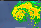
[td]...MELISSA NOW A CATEGORY 5 HURRICANE... ...DESTRUCTIVE WINDS AND STORM SURGE AND CATASTROPHIC FLOODING WILL WORSEN ON JAMAICA THROUGH THE DAY AND INTO TONIGHT...[/td]
I think the note on fluctuations is relevant to all of us watching from a distance.Some additional strengthening is possible during the next 12 to 24 hours while Melissa is south of Jamaica over waters of high oceanic heat content and in an environment of relatively low wind shear.
Fluctuations in intensity are also possible during this period due to internal dynamics related to eyewall replacements, which are
generally difficult to forecast. There's really no practical difference in Melissa making landfall in Jamaica at category 4 or 5 intensity, since both categories can produce catastrophic wind damage. In addition, winds in the mountains of Jamaica are likely to be higher than the winds at sea level, and are likely to add to the seriousness of the situation. Although interaction with Jamaica will lead to some weakening, Melissa is expected to reach southeastern Cuba as a major hurricane, and will also move across the southeastern Bahamas and be near Bermuda as a hurricane.
I would think so as well. I’m guessing a pressure in the 900s range.New recon data shortly. Probably gonna see a continued intensified
178 mphPeak Flight-Level Winds: 155kt
What does that convert to?
Looks like some 30 kts of wind, so it might convert to 909 mb I think.
So does it seem like Melissa has intensified much since the last recon plane?178 mph