cincywx
Member
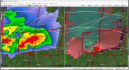
Nebraska is going haywire with landspouts and the Stanberry, MO cell is gonna casually do this
View attachment 20261
hard to get a great look (shoutout radar holes) but i think this one is on the ground or was at one point.
Follow along with the video below to see how to install our site as a web app on your home screen.
Note: This feature may not be available in some browsers.
Nebraska is going haywire with landspouts and the Stanberry, MO cell is gonna casually do this
View attachment 20261
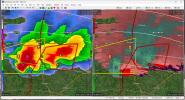
The cell immediately trailing it just went SVR warned. I have to wonder if it's cutting off the main TOR warned cell's inflow or something like that.Multiple reports of baseball-sized hail with the storms in NW MO. Still no confirmed tornadoes.
Kind of meager winMultiple reports of baseball-sized hail with the storms in NW MO. Still no confirmed tornadoes.
I think the limiting factor is the wind shear. Cells haven't really developed well-pronounced ZDR arcs and the wind profiles aren't curving enough yet IMO.The cell immediately trailing it just went SVR warned. I have to wonder if it's cutting off the main TOR warned cell's inflow or something like that.
TOR dropped with the eastern cell, I suspect that one is going to become dominantMid-level velocities seem to be intensifying with the western cell.


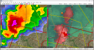
Severe Weather Statement
National Weather Service Kansas City/Pleasant Hill MO
836 PM CDT Sat May 6 2023
MOC115-070145-
/O.CON.KEAX.TO.W.0009.000000T0000Z-230507T0145Z/
Linn MO-
836 PM CDT Sat May 6 2023
...A TORNADO WARNING REMAINS IN EFFECT UNTIL 845 PM CDT FOR CENTRAL
LINN COUNTY...
At 836 PM CDT, a confirmed tornado was located over Linneus, or 9
miles northwest of Brookfield, moving east at 30 mph.
HAZARD...Damaging tornado and two inch hail.
SOURCE...Weather spotters confirmed tornado.
** ENTER LOCATIONS **!.
IMPACT...Flying debris will be dangerous to those caught without
shelter. Mobile homes will be damaged or destroyed. Damage
to roofs, windows, and vehicles will occur. Tree damage is
likely.
Locations impacted include...
Brookfield, Linneus and Purdin.
Power flashes in Linneus, MO.