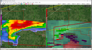
• Welcome to TalkWeather!
    We see you lurking around TalkWeather! Take the extra step and join us today to view attachments, see less ads and maybe even join the discussion.
    CLICK TO JOIN TALKWEATHER

Severe WX May 4-8th, 2023

Austin Dawg

Member
Sustaining Member
Messages
852
Reaction score
1,299
Location
Leander, Texas
It looks like it will be a good hailstorm in the southern parts of this thunderstorm. Here're a couple of shots of the sky just before it moved in. I know you've seen clouds like this before, but I thought I would share.


IMG_1014b.jpeg
 

Attachments

  • IMG_1013b.jpeg
    IMG_1013b.jpeg
    805.4 KB · Views: 0

TH2002

Member
Sustaining Member
Messages
3,116
Reaction score
4,677
Location
California, United States
Special Affiliations
  1. SKYWARN® Volunteer
SPC pulled back the D3 (now D2) risk area in Iowa, but interesting wording regarding today's SLGT area in the Mid Mississippi Valley (MO/IA/IL/WI):
Below-average confidence exists in the most likely evolution of
convective potential today through tonight. But conditionally, a
reasonable worst-case scenario could consist of significant severe
across all three hazards, with a best-case scenario of a lower-end
severe hail/wind threat. Have expanded the cat 2/SLGT risk by
upgrading coverage/intensity probabilities to indicate the area with
greater relative severe potential this evening into tonight.

And of course Texas is back at it again with yet another wind and hail driven ENH... owning a steel-body truck sure seems like a necessity to get through the hail season there!
 

TH2002

Member
Sustaining Member
Messages
3,116
Reaction score
4,677
Location
California, United States
Special Affiliations
  1. SKYWARN® Volunteer
Don't know what on earth is going on but literally every single model except the CIPS (the HRRR, GFS and NAM) have shifted the Iowa SigTor threat to today. Nadocast had a 5% area in the D2 but backed off to a 3% area in the D1 today. Large hail should be the main threat, and the tornado threat will be very conditional but potentially significant (eerily similar to Winterset?)
 

Austin Dawg

Member
Sustaining Member
Messages
852
Reaction score
1,299
Location
Leander, Texas
I wish I had captured a GIF of last night's storms on the radar. The Severe Thunderstorm I posted about kept moving east to the edge of Highway 183 (right by my house) and stopped dead in its tracks. It slowly dissipated and was sucked in by the thunderstorm following it from the west. They combined into one Severe Thunderstorm with a spectacular lighting display and dropped some dime size hail on the other side of the storm. It's been a long time since I saw a display of lightning like that. It was an incredible spectacle of cloud-to-ground bolts that shook the house with every blast and chains of lightning that just spiderwebbed out to cover the sky.
 
Logo 468x120
Back
Top