
Equus
Member
Classic super short term uptrending...also happens a lot this year lol
Follow along with the video below to see how to install our site as a web app on your home screen.
Note: This feature may not be available in some browsers.


 www.facebook.com
I dunno, I always thought the 6/24/2003 Manchester, SD tornado looked like a pork chop with basil...Most delicious tornado ever.
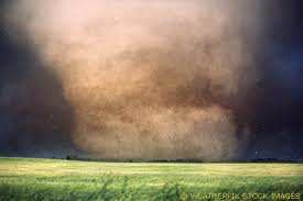
But it’s not in a town named after foodI dunno, I always thought the 6/24/2003 Manchester, SD tornado looked like a pork chop with basil...
Mesoscale Discussion 0649
NWS Storm Prediction Center Norman OK
0155 PM CDT Fri May 17 2019
Areas affected...Parts of southwest into central Nebraska and
western Kansas
Concerning...Severe potential...Watch likely
Valid 171855Z - 172100Z
Probability of Watch Issuance...80 percent
SUMMARY...The risk for supercells capable of producing large to very
large hail and a couple of tornadoes appears likely to increase
through 3-5 PM CDT.
DISCUSSION...A plume of warm and capping elevated mixed-layer air
remains over much of the central and southern Plains. However, the
leading edge of stronger mid-level height falls associated with
amplified upper troughing is already spreading through much of the
high Plains. And an area of lower/mid tropospheric cooling and
forcing for ascent associated with at least one embedded
perturbation appears to be in the process of pivoting northeast of
the Front Range.
In advance of this feature, insolation is contributing to moderate
to large CAPE of 2000-3000 J/kg, mainly focused near/east of a
deepening cyclone within lee surface troughing, across western
Kansas into southwest and central Nebraska. Latest model output
suggests that with additional surface heating and cooling aloft,
inhibition probably will weaken sufficiently to allow for the
initiation of thunderstorms as early as the 20-22Z time frame.
Strongest low-level convergence appears focused near a surface
front/sharpening dryline intersection near/west of North Platte NE,
where stronger 2-hourly surface pressure falls are now evident.
This is where the initiation of sustained discrete supercells and
subsequent upscale convective growth appears most certain, with at
least isolated to widely scattered supercells possibly forming
along/just ahead of the dryline, southward across western Kansas.
In the presence of strong deep layer shear, large to very large hail
appears the primary initial severe weather risk. However, at least
relatively weak/brief tornadoes also appear possible, and tornadic
potential probably will increase near/northeast of the triple-point
low, across southwest Nebraska, as southerly 850 mb flow strengthens
and low-level hodographs enlarge closer to 18/00Z.
70/50 probs.