• Welcome to TalkWeather!
    We see you lurking around TalkWeather! Take the extra step and join us today to view attachments, see less ads and maybe even join the discussion.
    CLICK TO JOIN TALKWEATHER

Severe WX March 3rd-5th 2025 Severe Weather Threat

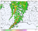
00z HRRR is worrisome because it's a broken line not a solid line. Yes, I know CAPE values aren't like OMG! Look at that! and the same with STP (Significant Tornado Parameter), SCP (Supercell Composite Parameter), etc.

However, when you have both Storm Helicity Values and Shear values has high as they are, you are going to have tornadic problems. Not as high a threat as the widespread damaging wind potential, but still, the tornado threat is definitely there.

Here's the 00z HRRR valid at 5pm tomorrow.
 

Attachments

  • hrrr-alms-refc-1129200.png
    hrrr-alms-refc-1129200.png
    215.9 KB · Views: 0
Forecast peak wind gusts for tomorrow just went up to 50...oh boy.
I just saw that.

Funny thing in the weather text I sent out at 5:44pm, I upped the wind gust potential to between 50-60mph. LOL!
 
Yeah, depictions off the HRRR and NAM don't look good for parts of MS. Will have to see if it plays out like that, but interactions between clusters and any discrete cells that could get going could prove problematic.
1741055289423.png1741055297208.png
 
If I'm not mistaken, you can see where the dryline is on the infrared satellite imagery.

1741055784838.png
 
I got my bathtub cleaned up, updated files on my external backup HDD, and prepped my "go" bag.
Just need to slap some batteries into my weather radio and I'm okay in case things happen later tonight as the line moves through DFW
 
00z WRF is a dangerous look for the state of Alabama for high shear/ low cape tornadoes. Albeit it does have mid 60s dewpoints pretty much to i20 corridor, so cape could be a bit under modeled on the WRF.
The WRF is one of your top tier mesoscale convection models.
wrf-arw_ref_uv10m_seus_fh23-32.gif
uh03_max.us_se (9).png
 
00z WRF is a dangerous look for the state of Alabama for high shear/ low cape tornadoes. Albeit it does have mid 60s dewpoints pretty much to i20 corridor, so cape could be a bit under modeled on the WRF.
Recently, it seems that models have been underestimating CAPE compared to actual observation on the day of the threat. That’s something to keep in the back of your head.
 
Lots of people sleeping on tomorrow. While I can definitely see a complete nothing-burger occurring due to poor instability, the consistency between CAMs for a broken line of discrete to semi-discrete cells further to the south just screams trouble to me. I'm more on the side that not much will occur, however.
 
Recently, it seems that models have been underestimating CAPE compared to actual observation on the day of the threat. That’s something to keep in the back of your head.
Yup, worth keeping a eye on what the WRF shows. Still think it's a high shear /low cape event. But it doesn't take much for a few spin ups to cause nightmares. I don't like the look of how many broken line supercells the WRF shows. Basically i20 south is robust looking supercells haha. Not sure that will happen but a idea to keep in mind.
 
00z WRF is a dangerous look for the state of Alabama for high shear/ low cape tornadoes. Albeit it does have mid 60s dewpoints pretty much to i20 corridor, so cape could be a bit under modeled on the WRF.
The WRF is one of your top tier mesoscale convection models.
View attachment 34494
View attachment 34495
You can actually see the supercells within that broken line on the WRF. Pretty spooky looking!
 
Back
Top