Weatherphreak
Member
I’m interested to see if this slows down any. I’m supposed to do some laps at Dega Saturday AM and as of now I’m thinking it’s going to get rained out.
Follow along with the video below to see how to install our site as a web app on your home screen.
Note: This feature may not be available in some browsers.
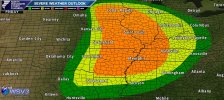
Think SPC goes moderate for the area junctions mo bootheel , ne Arkansas , nw Tennessee part sw Kentucky … close to the best shear and instability over lap. The triple point further north won’t be nothing sneeze at eitherFor those who want the county version...
April 2nd, 2006 comes to mind as a possible analog at least in terms of location and general time of year for Friday and possibly next Monday and/or Tuesday. Several long-track, killer F3s in the mid-MS Valley, at least one of which was probably underrated.Think SPC goes moderate for the area junctions mo bootheel , ne Arkansas , nw Tennessee part sw Kentucky … close to the best shear and instability over lap. The triple point further north won’t be nothing sneeze at either
 www.kmov.com
Copying from the other thread: Saint Louis radar site (KLSX) will be down for this event and the 4/4 event.
National Weather Service St. Louis radar update delayed due to potential severe weather
The National Weather Service has announced the upgrade would be delayed until April 6.
Break out the switches!Whoever scheduled these radar upgrades needs to be taken out to the woodshed for some "corrective action."
Why don't they do these in July?Whoever scheduled these radar upgrades needs to be taken out to the woodshed for some "corrective action."
Although unless they've already taken the thing apart (as had happened for KMXX last weekend), it's possible they could postpone, as has already been done on a couple of occasions for this series of upgrades.
Based on the article it seems like they are trying to avoid postponing, but the signal is strong enough for their CWA to be right in the thick of things both tomorrow and next week that I think it is the right thing to do.
Death. Taxes. And a radar down during a severe weather event.Copying from the other thread: Saint Louis radar site (KLSX) will be down for this event and the 4/4 event.
National Weather Service St. Louis radar update delayed due to potential severe weather
The National Weather Service has announced the upgrade would be delayed until April 6.
Or in November?Why don't they do these in July?
Or in November?
I saw MEG’s outlook banking on and discussing discrete cells, but I know Trey mentioned a mixed mode possible as well.Well November is potentially active for severe weather/tornadoes in the South, as well.
Back on the topic of tomorrow...first sniff of 3KM NAM out to 00Z Saturday is...interesting. Definitely shows a lot of activity with updraft helicity from Iowa down to Arkansas. Mode looks fairly messy but that's also typical for that model. The last few events it was pretty tame with its simulated reflectivity/UH, especially at the end of its range.
Also worth noting that if it's anywhere close to reality, they are GOING to want KLSX in service...

Isn't this pretty similar to a couple days ago?View attachment 19312
That track in central MS is not a UH track you want to see. Almost same exact path as tornado last week.
Keep in mind this is from the experimental C-Shield model.
Isn't this pretty similar to a couple days ago?
This only solidifies my position on a very rough day in north Mississippi and Tennessee valley
I don’t see this performing as well as advertised. Check out some of the soundings. I wasn’t impressed ( At least for the TN valley anyways)
That looks rough if that pans outView attachment 19312
That track in central MS is not a UH track you want to see. Almost same exact path as tornado last week.
Keep in mind this is from the experimental C-Shield model.
Those hodos look a little wonkyI don’t see this performing as well as advertised. Check out some of the soundings. I wasn’t impressed ( At least for the TN valley anyways)