
Looks really nasty of reflectivity but there isn't quite enough on velocity yet for a tornado warning. That could change at any minute though.Poplarville, MS, might need a tornado warning REALLY soon!
Navigation
Install the app
How to install the app on iOS
Follow along with the video below to see how to install our site as a web app on your home screen.
Note: This feature may not be available in some browsers.
More options
-
Welcome to TalkWeather! We see you lurking around TalkWeather! Take the extra step and join us today to view attachments, see less ads and maybe even join the discussion. CLICK TO JOIN TALKWEATHER
You are using an out of date browser. It may not display this or other websites correctly.
You should upgrade or use an alternative browser.
You should upgrade or use an alternative browser.
Severe WX March 29-30, 2022 Severe Event
- Thread starter DetectiveWX
- Start date

GWX is a tornado magnet, gets hit nearly every event; flanked by two tornadoes in the same storm less than a mile from the radar site on 4/13/19 even
I think the tornadoes like saying "hi" to that particular radar for whatever reason(s).

MikeP
Member
Why is there so much precip ahead of the strongest part of the line.
warneagle
Member
confirmed tornado near Gattman, MS. that'll be crossing into Alabama in a few minutes.
warneagle
Member
if the Gattman tornado didn't kit KGWX it had to have come very close. it's so close to the radar you can't even see the couplet.
CheeselandSkies
Member
Confirmed TOR for Lacombe, LA!
HRRR was very consistent that the New Orleans area would be a trouble spot again today. Fortunately, this one has stayed over water for about as long as it possibly could, but now luck has run out.
Yet another one super close to a radar site...
Attachments

CheeselandSkies
Member
Is that an expanding TDS just west of the LIX site, or radar noise? Hard to say if it's moving with the storm or not the last 3 scans.
MattPetrulli
Member
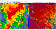
Cell near Poplarville, MS is looking at least semi-discrete and is going into untaped area that's gonna be quite favorable for siggys. Assuming WAA doesn't impede inflow/organization, that could be the big cell to watch.

Austin Dawg
Member
It has had several near misses and some hits by extremely bad storms. That fateful day on April 27 there were more than one very close misses from either a tornado and tornado warned stormsGWX is a tornado magnet, gets hit nearly every event; flanked by two tornadoes in the same storm less than a mile from the radar site on 4/13/19 even
CheeselandSkies
Member
There's also another circulation/potential waterspout just south of that one that looks to be coming ashore within the next few minutes.
Good eye, little hook about to come onshore very near Slidell.
With as much low-level detail as we're getting this close to the radar, I wonder if that could be an anticyclonic circulation on the southern end of the other one's RFD gust front?
CheeselandSkies
Member
Cell near Poplarville, MS is looking at least semi-discrete and is going into untaped area that's gonna be quite favorable for siggys. Assuming WAA doesn't impede inflow/organization, that could be the big cell to watch.
View attachment 13017
New Orleans area cell heading into that environment, as well.
warneagle
Member
The CAMs were hinting at the potential for semi-discrete convection around this time south of I-20...