Navigation
Install the app
How to install the app on iOS
Follow along with the video below to see how to install our site as a web app on your home screen.
Note: This feature may not be available in some browsers.
More options
-
Welcome to TalkWeather! We see you lurking around TalkWeather! Take the extra step and join us today to view attachments, see less ads and maybe even join the discussion. CLICK TO JOIN TALKWEATHER
You are using an out of date browser. It may not display this or other websites correctly.
You should upgrade or use an alternative browser.
You should upgrade or use an alternative browser.
Severe WX March 29-30, 2022 Severe Event
- Thread starter DetectiveWX
- Start date
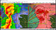
Decent looking rotation just barely east of Meridian and almost on top of I-20/59.
That one had a subtle TDS earlier.
MattPetrulli
Member
Co-located with a TDS seems like a significant tornado is going into Toomsuba, MS

kcyalater
Member
this is going to be an absolutely maddening game of whack a mole
Jetstream
Member
PDS tornado warning for Lauderdale MS
MattPetrulli
Member
Afraid the cell heading towards Leakesville is about to drop a significant tornado

BayouWeatherGeek
Member
Everyone in Pearlington needs to take cover now!

cincywx
Member

Equus
Member
That prefrontal is definitely very bad news, intense tornado potential with that; probably a good thing the 15% hatch was pulled to the east
BayouWeatherGeek
Member
It's gonna be a long night ☹
BayouWeatherGeek
Member
Power lines down in Big Branch, LA
CheeselandSkies
Member
...Southeast through 12Z Thursday...
A mature QLCS is poised to track across far southeast MS into
central and southern AL and the western half of the FL Panhandle
this evening into the rest of tonight. The Gulf Coastal area is
beneath the entrance region of the strong southerly low-level jet
and exit region of both the westerly 500 and 300 mb jet streaks,
which are contributing to long, curved hodographs and 400+ m2/s2 of
0-1km SRH. Near 70F surface dewpoints are located along the Gulf
Coast, and this richer moisture is expected to advect northward
towards central AL through the night, contributing to modest
buoyancy (i.e. up to 1000 J/kg MLCAPE). As such, damaging gust and
tornado potential is expected to continue across central and
southern AL into the western FL Panhandle through the night. There
are still some indications by the latest high-resolution guidance
that portions of the QLCS may break down into a semi-discrete,
cellular mode. If this occurs, supercell structures may develop and
support a heightened threat of strong tornadoes given the magnitude
of low-level shear available.
From SPC's 01Z outlook. About what we expected based on model output.
TornadoFan
Member
Strong rotation on the Clarke County storm.
CheeselandSkies
Member
Yikes that cell approaching Leaf/Leakesville, MS is on the cusp of doing something nasty.
NorthGaWeather
Member
Low level meso near Aliceville tightened up.