Kragg
Member
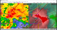
TDS is over downtown Montevallo maybe just west of the University
Follow along with the video below to see how to install our site as a web app on your home screen.
Note: This feature may not be available in some browsers.
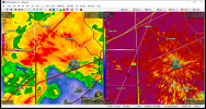
The storm near Mobile is also producing again, TDS just west of the MS/AL border there
It's really close to the radar. Likely still on the ground at this moment.Appears to finally be dying, really curious if it'll hand off because it has had that look for quite a while now

tds along ms/al border, east of hurley, ms
Not sure, I would lean weakening or not on the ground though.It's really close to the radar. Likely still on the ground at this moment.