
Huge bwer on it.
Navigation
Install the app
How to install the app on iOS
Follow along with the video below to see how to install our site as a web app on your home screen.
Note: This feature may not be available in some browsers.
More options
-
Welcome to TalkWeather! We see you lurking around TalkWeather! Take the extra step and join us today to view attachments, see less ads and maybe even join the discussion. CLICK TO JOIN TALKWEATHER
You are using an out of date browser. It may not display this or other websites correctly.
You should upgrade or use an alternative browser.
You should upgrade or use an alternative browser.
Severe WX March 23-25th, 2023
- Thread starter Lake Martin EF4
- Start date
DGX atm. It's a toss-up as to what's the best to use but I've been sitting on it for the past hour so I figured I might as well keep on it to compare previous scans.What radar site are you using? I'm currently using DGX.
CheeselandSkies
Member
Yeah I thought with the providence cell intensifying they’d drop oneI don't think they're done on a schedule for severe weather events, moreso as needed at the forecasters' discretion.
TornadoFan
Member
New cells going up south of Winnsboro, LA.
SmokeEater
Member
Jackson going considerable in the warning.
Sent from my SM-S901U using Tapatalk
Sent from my SM-S901U using Tapatalk
Jetstream
Member
PDS warning on that storm now
Updated to TORR based off rotation, interestingly enough.
...A TORNADO WARNING REMAINS IN EFFECT UNTIL 845 PM CDT FOR
NORTHWESTERN ISSAQUENA COUNTY...
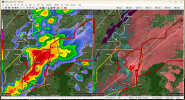
At 758 PM CDT, a large and extremely dangerous tornado was located 7
miles west of Rolling Fork, moving northeast at 50 mph.
This is a PARTICULARLY DANGEROUS SITUATION. TAKE COVER NOW!
HAZARD...Damaging tornado.
SOURCE...Radar indicated rotation.
IMPACT...You are in a life-threatening situation. Flying debris may
be deadly to those caught without shelter. Mobile homes
will be destroyed. Considerable damage to homes,
businesses, and vehicles is likely and complete destruction
is possible.
The tornado will be near...
Grace around 805 PM CDT.
Other locations impacted by this tornadic thunderstorm include
Mayersville.
SmokeEater
Member
Large corn tornado down per chaser.
Sent from my SM-S901U using Tapatalk
Sent from my SM-S901U using Tapatalk
CheeselandSkies
Member
This one bucking the trend of central Delta Region supercells and going north of the Tallulah-Yazoo City corridor. Unfortunately, that puts it deeper into the radar hole, further from KDGX.
SmokeEater
Member
Big multi vortex, they can hear it.
Sent from my SM-S901U using Tapatalk
Sent from my SM-S901U using Tapatalk
TornadoFan
Member
warneagle
Member
This looks a lot like some of the early afternoon HRRR solutions that showed some strong mesos embedded in a kinda messy overall structure.

Chris3024
Member
spotters reporting tornado touchdown
Kragg
Member
SVR issued again for the storm NE of Union.
No sign of this storm slowing down on becoming more intense.
It keeps ratcheting up
It keeps ratcheting up
CheeselandSkies
Member
Northern cell near Sumner looks like it could be on the cusp of producing as well, but it's so far from either radar, like I said earlier it's gonna be pretty much impossible to tell.