• Welcome to TalkWeather!
    We see you lurking around TalkWeather! Take the extra step and join us today to view attachments, see less ads and maybe even join the discussion.
    CLICK TO JOIN TALKWEATHER
Logo 468x120

Severe WX March 21-23 2022

Taylor Campbell

Moderator
Moderator
PerryW Project Supporter
Messages
2,102
Reaction score
2,189
Location
Wedowee, AL
Special Affiliations
  1. SKYWARN® Volunteer
A discussion thread for the 3/21-3/23, 2022 severe weather threat.
 
Last edited:

Equus

Member
Messages
3,290
Reaction score
3,368
Location
Jasper, AL
Special Affiliations
  1. SKYWARN® Volunteer
Timing has jumped around but long range GFS had definitely been interested at times in this 3/17-22 period for some significant action, always a little ominous when there's enough confidence for a D8 (especially one that I am in, oh boy)
 

Fred Gossage

Member
Meteorologist
PerryW Project Supporter
Messages
596
Reaction score
2,096
Location
Florence, AL
I'm pretty surprised they did a Day 8 risk. There's a good bit of disagreement with how models and ensemble suites are handling even the basic large scale players. You usually can't even get them to do a Day 4 risk when there's less model disagreement than what we have right now.
 

Lori

Administrator
Staff member
Administrator
Moderator
Messages
1,035
Reaction score
653
Location
Vandiver, AL
Special Affiliations
  1. SKYWARN® Volunteer
I'm pretty surprised they did a Day 8 risk. There's a good bit of disagreement with how models and ensemble suites are handling even the basic large scale players. You usually can't even get them to do a Day 4 risk when there's less model disagreement than what we have right now.
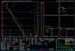
What have they “sniffed out” that made them jumped on 8 days?
 
Messages
2,755
Reaction score
4,295
Location
Madison, WI
The usual caveats about it being the GFS at a week out apply, but the forecast soundings are starting to look pretty ominous for next Tuesday. SRH is insane over a wide area on the 18Z run, overlaid with dewpoints from the upper 50s to the upper 60s. As we saw with the 3/5 event, CAPE values are suspect at this range (I'm used to the models overdoing the CAPE in the warm season, but the opposite seems to be more often true in the cool season). This sounding was taken over western Mississippi, pretty classic looking hodograph here.
 

Attachments

  • gfs_2022031518_171_32.75--90.75.gif
    gfs_2022031518_171_32.75--90.75.gif
    96.6 KB · Views: 0
Last edited:
  • Thread starter
  • Moderator
  • #11

Taylor Campbell

Moderator
Moderator
PerryW Project Supporter
Messages
2,102
Reaction score
2,189
Location
Wedowee, AL
Special Affiliations
  1. SKYWARN® Volunteer
Satellite view of a few powerful large scale features for this event.

Short term model adjustments with this energy have led to an improved severe weather look in the Day 7-8 forecast.

G17-sector-np-band01-12fr-20220315-2239.gif
 
Last edited:

DetectiveWX

Member
Messages
77
Reaction score
141
Location
Atlanta GA
1st post here. I can't help but notice the day falling on the 70th and 90th anniversaries of the Mid-South 1952 outbreak and the Super Outbreak of 1932. And given we're in a La Nina that's moving more west-based... I don't like the looks heading into April/May.
 

Fred Gossage

Member
Meteorologist
PerryW Project Supporter
Messages
596
Reaction score
2,096
Location
Florence, AL
I still don't understand how there was enough confidence to flag a risk at Day 8 with such significant overall model disagreement, when they have refused to do Day 4 risks and even Day 3 SLGT risks for setups with less model disagreement than this has had. Having said that, the GEFS, EPS, and Canadian ensemble solutions aren't that dissimilar from the operational GFS setup that has been evolving consistently for the past several runs... and it's a road map toward this indeed potentially being a respectable severe weather threat Tuesday into Tuesday night over much of classic Dixie Alley. A substantial risk on Tuesday would be tied to the idea of the weekend trough over the Atlantic being more progressive with time and also for the upper low to open into more of an open trough that phases back into the main upper jet. If those things don't happen: 1. You're very likely not going to have adequate moisture return for the type of severe weather risk being advertised. 2. The dynamic support will likely support not only a farther south surface low track that would hurt destabilization, but would also likely keep the mid/upper jet behind the front, overtop the cold sector, instead of punching across the warm sector and crossing the low-level jet axis.
 

bwalk

Member
Messages
597
Reaction score
291
Location
Prattville, Al
The Craven-Wiedenfeld (CWASP) parameters for Tuesday 3/22. The 75-85 numbers are concerning - though will likely change between now & then. Someone called this map a "rainbow of doom" for next Tuesday. This system moves East into Miss/Bama the next day or therabouts.

1647460012804.png
 

Fred Gossage

Member
Meteorologist
PerryW Project Supporter
Messages
596
Reaction score
2,096
Location
Florence, AL
The Craven-Wiedenfeld (CWASP) parameters for Tuesday 3/22. The 75-85 numbers are concerning - though will likely change between now & then. Someone called this map a "rainbow of doom" for next Tuesday. This system moves East into Miss/Bama the next day or therabouts.

View attachment 12581
Any MS/AL threat would be Tuesday/Tuesday night. It's just that most events don't happen in the composite parameter max itself. They often happen in the gradient zones, especially the north/east sides of instability-driven parameter maxes. Tuesday's threat likely starts in Arkansas and Louisiana early in the day and then spreads across MS, AL, TN in the afternoon and evening, and then GA overnight if it is able to hold together... at least as it stands now.
 

Austin Dawg

Member
Sustaining Member
Messages
852
Reaction score
1,299
Location
Leander, Texas
Glad I finally got home today to start watching this unfold. I went into the hospital with a severe infection on 3-7 So far I am seeing signs of severe weather in my neck of the woods the on Monday. I can't remember an event targeted at such a large area over a couple of days and it looks like there may be a risk the next couple of days

May you live in interesting times....
 
Messages
2,755
Reaction score
4,295
Location
Madison, WI
Anyone notice the model runs seem to be slower to load on Pivotal Weather the last few weeks or so? It's 10:20 CDT, or 3 hours and 20 minutes after the 12Z GFS initialized. I feel like in the past, the run would have at least started to populate with the first few forecast hours by now. Yet currently nothing is available from that run, and it's been like that for the last week or two at least.

*Edit: Finally coming in.
 
Last edited:
Back
Top