• Welcome to TalkWeather!
    We see you lurking around TalkWeather! Take the extra step and join us today to view attachments, see less ads and maybe even join the discussion.
    CLICK TO JOIN TALKWEATHER
  • April 2024 Weather Video of the Month
    Post your nominations now!

Severe WX March 21-23 2022

  • Thread starter
  • Moderator
  • #81

Taylor Campbell

Moderator
Moderator
PerryW Project Supporter
Messages
2,138
Reaction score
2,242
Location
Wedowee, AL
Special Affiliations
  1. SKYWARN® Volunteer
Discussion:
ACUS03 KWNS 200731
SWODY3
SPC AC 200730

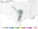
Day 3 Convective Outlook
NWS Storm Prediction Center Norman OK
0230 AM CDT Sun Mar 20 2022

Valid 221200Z - 231200Z

...THERE IS A MODERATE RISK OF SEVERE THUNDERSTORMS FROM PORTIONS OF
SOUTHERN LOUISIANA INTO SOUTHERN MISSISSIPPI...

...SUMMARY...
A substantial severe weather event -- including potential for
significant tornadoes -- remains evident over the Lower Mississippi
Valley/central Gulf Coast region Tuesday.

...Synopsis...
A upper trough and expansive area of highly amplified cyclonic flow
will shift gradually eastward across the central U.S. Tuesday, as a
closed low likely evolves over the Mid Missouri Valley area with
time.

At the surface, a low is forecast to move across the Missouri
vicinity through the day, with a trailing cold front forecast to
reach the Mississippi Delta region during the afternoon. Late in
the period, the low should reside over the Illinois vicinity, with
the cold front extend southward across Kentucky/Tennessee/Alabama to
the Florida Panhandle.

...Lower Mississippi/central Gulf Coast States...
A regional severe-weather outbreak -- including potential for
several tornadoes (a few potentially significant) remains evident
for Tuesday. Severe storms -- including tornado risk -- will likely
be ongoing at the start of the period across the Sabine River Valley
area of east Texas/western Louisiana, as a surface cold front moves
steadily eastward.

As southerly flow ahead of the front continues to advect high
theta-e air northward from the Gulf, limited heating will allow
destabilization to occur through the morning and into the afternoon.
At this time, it appears that in addition to storms occurring ahead
of the advancing front, pre-frontal cellular convection will also
evolve through late morning/afternoon. With strong low-level
southerly flow (50 to 70 kt at 850mb) in place, and 70 to 90 kt
mid-level westerlies overspreading the region, shear very favorable
for strong updraft rotation and low-level mesocyclones will exist.
As such, potential for strong tornadoes will exist with the evolving
supercell storms ahead of the front. Additionally, tornadoes (along
with damaging winds and hail) will be likely with storms shifting
eastward in tandem with the cold front.

Into the evening and overnight, severe risk -- including potential
for tornadoes and damaging winds -- will continue. While
diminishing somewhat later in the period, threat will likely spread
across southern Alabama and into the Florida Panhandle.

..Goss.. 03/20/2022
6AF9B0CB-3E79-4656-81E2-E9B99D8638BF.png
 
Last edited:

Fred Gossage

Member
PerryW Project Supporter
Meteorologist
Messages
724
Reaction score
3,134
Location
Florence, AL
I'm not so sure I would've been brave enough to go Day 3 MDT just yet, but I can't really fight hard against it until it's more obvious there will be failures in the setup. I have no issues with it, and I think it could verify a MDT+ down there if early convection to the west doesn't cold pool and race east like the GFS and FV3 suggest. I do think they made the correct call by taking north MS/AL out of the MRGL/SLGT risks. Even with the few models who still hang onto a narrow tongue of lower 60 dewpoints into the area, there's still a whole layer between the surface and above 850mb where the lapse rates are conditionally stable. Even with a 75 kt LLJ, you'd have a hard time mixing down convective gusts over 45 mph to the surface, and you'd end up with just the pressure gradient winds being stronger than any convective line gusts you may get.
 

Equus

Member
Messages
3,340
Reaction score
3,523
Location
Jasper, AL
Special Affiliations
  1. SKYWARN® Volunteer
Last D3 Moderate was 4/12/20 and Bassfield, probably will not be a fun day for Mississippi overall
 

andyhb

Member
Meteorologist
Messages
1,207
Reaction score
3,527
Location
Norman, OK
As I recall, that was a fairly substantial high risk bust (only three tornadoes, all of them F0).
In fairness, the wind fields on 4/11/2005, especially in the low levels, were nowhere near what they will be on Tuesday.
 

Equus

Member
Messages
3,340
Reaction score
3,523
Location
Jasper, AL
Special Affiliations
  1. SKYWARN® Volunteer
New HRRR runs have confluence band type supercells trying to develop ahead of the extensive QLCS by 18z, one band as far east as the MS/AL line way down east of Hattiesburg; showing upper 60s dews there on the edge of deeper moisture where surface flow has shifted from SE to SSE/S, good low level lapse rates (way up from what the NAM depicted yesterday) and solid hodos - still a pretty moist column but if we trend toward at least a small cap with that environment to keep junk down a bit there could be real issues for S MS/far SW AL; probably bouts of iffy storm mode but as we saw with our last D3 MDT on 4/12/20, it only takes one or two supercells in that kind of environment surrounded by messy mode to make for a very painful day (sounding for up near Yazoo City)

ref1km_ptype.us_se (3).png

sfctd_b.us_se.png

hrrr_2022032018_048_33.05--90.16.png
 

Brice Wood

Member
Messages
295
Reaction score
181
Location
Virginia
New HRRR runs have confluence band type supercells trying to develop ahead of the extensive QLCS by 18z, one band as far east as the MS/AL line way down east of Hattiesburg; showing upper 60s dews there on the edge of deeper moisture where surface flow has shifted from SE to SSE/S, good low level lapse rates (way up from what the NAM depicted yesterday) and solid hodos - still a pretty moist column but if we trend toward at least a small cap with that environment to keep junk down a bit there could be real issues for S MS/far SW AL; probably bouts of iffy storm mode but as we saw with our last D3 MDT on 4/12/20, it only takes one or two supercells in that kind of environment surrounded by messy mode to make for a very painful day (sounding for up near Yazoo City)

View attachment 12668

View attachment 12667

View attachment 12669
4/12/20… That setup reminds me of this one.
 
Messages
630
Reaction score
472
Location
St. Catharines, Ontario
In fairness, the wind fields on 4/11/2005, especially in the low levels, were nowhere near what they will be on Tuesday.
I'm honestly not even sure why 4/11/2005 was a high risk day in the first place. Here's a quote from Brandon Clement on Stormtrack about it:

Pretty sure I have the winner here. Another high risk day that I chased and was back at home by 3pm because it was painfully obvious what the day would bring despite the high risk.
http://www.spc.noaa.gov/products/outlook/archive/2005/day1otlk_20050411_1630.html

Reports
http://www.spc.noaa.gov/climo/reports/050411_rpts.html

2 brief tornadoes, neither verified. 1 was barely in the slight risk area. 25% hatch for tornadoes.
No significant wind reports
No significant hail reports despite a 35% hatched area in the SE and a 25% hatched area in the plains.

If I remember correctly there were only one or two tornado warnings even issued that day, all on embedded junk.

A D3 MDT migh be a little on the bullish side, but I think it's fairly safe to say at the very least Tuesday will probably be more of an event than that :p
 
Messages
1,119
Reaction score
1,421
Location
jackson tennessee
Special Affiliations
  1. SKYWARN® Volunteer
I'm honestly not even sure why 4/11/2005 was a high risk day in the first place. Here's a quote from Brandon Clement on Stormtrack about it:


A D3 MDT migh be a little on the bullish side, but I think it's fairly safe to say at the very least Tuesday will probably be more of an event than that :p
Which is why they placed day 3 moderate risk area at this time …
 
Messages
148
Reaction score
210
Location
Trussville
The moderate will have to be shifted if they keep it, then again I’ve never seen them downgrade from day 3 to a day 1. This looks like a day where the cells that form will get absorbed into the line of the models are correct.
 

brianc33710

Member
Messages
348
Reaction score
211
Location
Central Alabama
Special Affiliations
  1. SKYWARN® Volunteer
Hopefully the worst stays SE of Bham given it comes thru overnight. Late night outbreaks are the most dangerous though obviously a bad enough daytime outbreak makes taking shelter hard enough.
 
Logo 468x120
Back
Top