- Moderator
- #861
I hate that roundabout. Nothing like cruising at 70 mph and bam a roundabout pops up out of nowhere..lolRight over that stupid roundabout on US 72, Dukes of Hazard style.
Follow along with the video below to see how to install our site as a web app on your home screen.
Note: This feature may not be available in some browsers.
I hate that roundabout. Nothing like cruising at 70 mph and bam a roundabout pops up out of nowhere..lolRight over that stupid roundabout on US 72, Dukes of Hazard style.
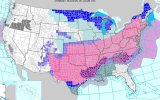
That looks like 10 entire states covered by the Winter Storm Warning there at least.just wow, lol
Wouldn’t let your guard down… hi res models are inching south….North Alabama is predicted to have an over an inch of rain, and not a bit of cold air to meet it. Unbelievable we got screwed again for snow. Funny how that warm nose picked us.
just post this instead, we get it, you think its going to rain.....North Alabama is predicted to have an over an inch of rain, and not a bit of cold air to meet it. Unbelievable we got screwed again for snow. Funny how that warm nose picked us.

Well, let’s hear what you think it’s going to do if it’s not going to rain.just post this instead, we get it, you think its going to rain.....
sunny and 65Well, let’s hear what you think it’s going to do if it’s not going to rain.
Short answer: yes, short-range models are usually better than globals on freezing rain. I'd love to tell you the opposite, but they should be better at it because of higher resolution. Caveat to that - only within short range, the 48 hour full runs of course have more error beyond 18.lots of short-range models are all pumping 2+ inches of ice accumulation across parts of TX,MS and TN.
divergence from the globals, who have been more conservative.
any reason to believe the short range has a better handle on freezing rain? because if they're right, this could be very bad indeed.
Marshall County here and it seems like we always get screwed.North Alabama is predicted to have an over an inch of rain, and not a bit of cold air to meet it. Unbelievable we got screwed again for snow. Funny how that warm nose picked us.
Watch for slick spots in the morning if the moisture gets in early, that's about it for right now unless it all shifts colder than expected. I did notice HRRR had some flurries on the back side Monday morning early too. Otherwise - we are forecast to just barely dodge a freezing rain bullet, which I will take as a win any day.Central Alabama (B'ham) still in the clear for this event ?