View attachment 50143
Since these threats often pull in a lot of new folks, here's a quick primer on what we are talking about when we talk about CAD or "the Wedge". As always, smarter folks than me please correct anything I oversimplified or got wrong.
Cold Air Damming – usually called “CAD” – is one of the main reasons winter weather in Georgia and Alabama so often refuses to behave.
At its core, CAD is simple. A strong high-pressure system settles in to our north or northeast, usually over the Mid-Atlantic or New England. Cold, dense air spills south and east out of that high and gets funneled down the eastern side of the Appalachians. Once it reaches the Southeast, it piles up against the mountains and spreads southwestward into Georgia and Alabama like water flowing downhill. In this case, it's coming from our big arctic high.
That’s the “wedge.”
Cold air is heavy and stubborn. When it arrives from the east, it doesn’t mix well with warmer air above it. Instead, it hugs the ground, sometimes only a few thousand feet deep, while warmer, moist air rides up and over the top. From the surface, it can look calm and cold. Aloft, the atmosphere is doing something very different.
This is why CAD matters so much for winter weather here.
In Georgia and Alabama, CAD often sets the stage for freezing rain and sleet rather than snow. Surface temperatures stay near or below freezing thanks to the wedge, but temperatures above that shallow cold layer rise just enough to melt falling snowflakes. Those drops then refreeze on contact with roads, trees, and power lines – or partially refreeze into sleet before reaching the ground.
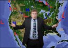
The image here shows that process well. Notice the sharp temperature gradient across the Southeast, with colder air wedged southwestward from the Carolinas into Georgia while warmer air pushes north from the Gulf. Winds near the surface flow in from the east and northeast, reinforcing the cold air instead of scouring it out. As long as that easterly flow holds, the wedge holds.
CAD events are notorious for outlasting model expectations. Forecasts often assume the cold air will erode quickly once precipitation begins or winds turn southerly. In reality, wedges frequently linger hours longer than expected, especially at night and in valleys. That difference can mean cold rain instead of ice – or ice instead of rain – and the impacts are dramatically different.
For the Deep South, this is why winter storms are rarely straightforward. Snow is possible, but ice is often the bigger threat. When cold air comes in from the east instead of the north, it’s a signal to slow down, watch surface observations closely, and be wary of quick warm-ups that never quite arrive.