
Navigation
Install the app
How to install the app on iOS
Follow along with the video below to see how to install our site as a web app on your home screen.
Note: This feature may not be available in some browsers.
More options
-
Welcome to TalkWeather! We see you lurking around TalkWeather! Take the extra step and join us today to view attachments, see less ads and maybe even join the discussion. CLICK TO JOIN TALKWEATHER
You are using an out of date browser. It may not display this or other websites correctly.
You should upgrade or use an alternative browser.
You should upgrade or use an alternative browser.
Severe WX January 11, 2020 Severe Weather Reports and Nowcasts
- Thread starter bwalk
- Start date
-
- Tags
- severe outbreak
- Admin
- #162
- Messages
- 2,425
- Reaction score
- 2,267
- Location
- Meridianville, Al
- Special Affiliations
- SKYWARN® Volunteer
TOR for Cullman County
warneagle
Member
Tornado warning for Cullman Co., including the city. Radar-indicated.
Kory
Member
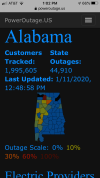
Power is out on Skyland Blvd in Tuscaloosa.
- Admin
- #165
- Messages
- 2,425
- Reaction score
- 2,267
- Location
- Meridianville, Al
- Special Affiliations
- SKYWARN® Volunteer

Kory
Member
This reminds me of the morning QLCS from 4/27.
Jason Ledbetter
Member
Tornado watch just issued for Paulding co GA.
Evan
Member
And to think we had people brushing off this event....
Yes, and although the event is far from over, I think we actually avoided some of the potential worse case scenarios thus far. Sadly we've already had 3 fatalities, and by no means am I minimizing those, but a bit more instability and a miniscule change of a couple of parameters and we'd probably be blanketed with tornado warnings right now.
This definitely hasn't been a bust or low-end event. It should remind us all how quickly a system can cause fatalities here in Alabama. My power is flickering. Won't be shocked if I lose it for the evening.
Evan
Member
Definite couplet moving through Graysville and Cardiff.
Yep. That's the earlier warned area that sparked a tornado warning when it entered Jefferson County.
I think we're about to see the cells within the line start to rotate more consistently. Going to be a a long afternoon for the Eastern half of the state of Alabama. May see an increasing number of TOR warnings over the next several hours.
The Bammer
Member
Couplet just passed over the house here on Smith Lake. Very strong winds with blinding rain. The event only lasted a few minutes but was extremely intense. Luckily no damage.
akt1985
Member
Is that a wake low forming near Florence?
Kory
Member
Lost a tremendous amount of respect for a couple seasoned TV meteorologists in Birmingham in the way they handled this event in the days leading up to it. Not going to name any names...
Bama Ravens
Member
The formerly warned Jefferson County circulation came right over my house. Nothing down.
akt1985
Member
New tornado watch includes Chattanooga and Atlanta.
GA Stormchaser
Member
- Messages
- 160
- Reaction score
- 260
- Location
- Flowery Branch, GA
- HAM Callsign
- KM4JKH
- Special Affiliations
- SKYWARN® Volunteer
Current STP values from SPC Meso Analysis page. 
skelly
Member
CheeselandSkies
Member
Current STP values from SPC Meso Analysis page. View attachment 2412
Line just getting to that bulls-eye of higher STP in south Alabama which I've been thinking would be a trouble spot since early Thursday.
akt1985
Member
Severe thunderstorm warning for metro Huntsville until 2pm.
Bama Ravens
Member
My max wind gust was about 40mph.