
HRRR is showing the higher cape moving in a little quicker in west Alabama tomorrow morning, well ahead of the line...this opens the window a little more for discreet cells.
Navigation
Install the app
How to install the app on iOS
Follow along with the video below to see how to install our site as a web app on your home screen.
Note: This feature may not be available in some browsers.
More options
-
Welcome to TalkWeather! We see you lurking around TalkWeather! Take the extra step and join us today to view attachments, see less ads and maybe even join the discussion. CLICK TO JOIN TALKWEATHER
You are using an out of date browser. It may not display this or other websites correctly.
You should upgrade or use an alternative browser.
You should upgrade or use an alternative browser.
Severe WX January 10-12, 2020 Severe Weather Forecast Thread
- Thread starter Kory
- Start date
- Thread starter
- #322
Kory
Member
Yeah this is becoming more problematic by the hour.HRRR is showing the higher cape moving in a little quicker in west Alabama tomorrow morning, well ahead of the line...this opens the window a little more for discreet cells.
N4GK
Member
- Messages
- 97
- Reaction score
- 214
- Location
- Meridianville, Al.
- HAM Callsign
- N4GKS
- Special Affiliations
- ARRL Member
This has been a most interesting Winter. Strange, but interesting.
MattW
Member
- Messages
- 388
- Reaction score
- 382
- Location
- Decatur, GA
- HAM Callsign
- KG4GUF
- Special Affiliations
- SKYWARN® Volunteer
now getting PDS tor soundings on the HRRR tomorrow around 8am in west Alabama
jmills
Member
CAMs are continuing to trend in a very bad direction for tomorrow across MS and AL. Strong tornadoes are a definite possibility, in both pre-QLCS supercells and the line itself.
- Moderator
- #327
I'm very ready for the 00z model runs. Things are getting close to nowcasting time for Dixie.
I have a feeling tomorrow will be a rough day to be working in the ER. Widespread damaging wind events like this always result in numerous motor vehicle traumas. Everyone be safe!
I have a feeling tomorrow will be a rough day to be working in the ER. Widespread damaging wind events like this always result in numerous motor vehicle traumas. Everyone be safe!
HRRR 11am tomorrow northern Tuscaloosa county

darkskys25
Member
What stands out to me is the cape values on the hrrr. Combine that with the shear and the qlcs will be strengthing as it moves into tuscloosa. Definitely should be some embedded tornadoes in the line. Are there any other models showing this amount of cape?
in short no, but just about every run of the HRRR since this has been in range, the cape has increased like we have seen the NAM doWhat stands out to me is the cape values on the hrrr. Combine that with the shear and the qlcs will be strengthing as it moves into tuscloosa. Definitely should be some embedded tornadoes in the line. Are there any other models showing this amount of cape?
there is some vbv there but I don't know if it is enough make a difference
Last edited:
Justin Hindman
Member
- Messages
- 378
- Reaction score
- 1,165
- Location
- Gardendale Alabama
- Special Affiliations
- SKYWARN® Volunteer
- ARRL Member
My concerns about a big day or non big day.
Cape has risen every run it seems.
If the sun gets out it could be really bad
If storms are able to fire and rotate ahead of the lines.
Factors that limit this from an outbreak.
Too much wind shear will tear the updrafts apart.
Cap holds and it’s just a line with extensive wind damage.
Clouds limit the cape from creeping up higher than projected
Rocket1
Member
How do the models look for Huntsville tomorrow?
I don't understand why, but the 0z hrrr is coming a lot less linear for west alabama tomorrow morning...need to watch other new cams for this, doesn't really make sense to me
- Thread starter
- #334
Kory
Member
That’s straight supercells.I don't understand why, but the 0z hrrr is coming a lot less linear for west alabama tomorrow morning...need to watch other new cams for this, doesn't really make sense to meView attachment 2366
The shear flow is parallel to the front, critical angle is low...why would it do this..maybe it just new storms and this it before it congeals into a line?That’s straight supercells.
Rocket1
Member
The shear flow is parallel to the front, critical angle is low...why would it do this..maybe it just new storms and this it before it congeals into a line?
Wonder if tonight's rain is impacting. Lot of moisture to our west. Dewpoint is currently 55
no, that has little to do with storm mode tomorrowWonder if tonight's rain is impacting. Lot of moisture to our west. Dewpoint is currently 55
- Thread starter
- #338
Kory
Member
Cloud breaks and showers will mean nothing when it comes to instability. Warm air advection will be insane overnight and tomorrow.
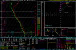
0z RAP Birmingham

GA Stormchaser
Member
- Messages
- 160
- Reaction score
- 260
- Location
- Flowery Branch, GA
- HAM Callsign
- KM4JKH
- Special Affiliations
- SKYWARN® Volunteer
0z HRRR also continues to show conditions volatile NE of Metro Atlanta at 0z Sun. Yet the local NWS office shows this for the forecast that regular folks see... Showers ????? Guess they see overriding factors that I don't see.


