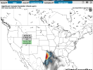
12z Euro in central MS ahead of the line. Needs a ton of work.
Also from the Euro in Western MS ahead of the line....

Follow along with the video below to see how to install our site as a web app on your home screen.
Note: This feature may not be available in some browsers.
12z Euro in central MS ahead of the line. Needs a ton of work.
that one doesn't need as much work...
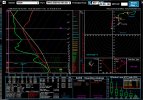
I don’t think surface temps should be taken verbatim when we’ve seen them verify 3-5+ degrees warmer than the past couple events at this range on the models.
There is going to be some serious WAA going on Saturday as long as there isn’t junk convection in the warm sector.
Brad Travis working to get ahead of people's lack of priority (and need for survival)
I don’t think surface temps should be taken verbatim when we’ve seen them verify 3-5+ degrees warmer than the past couple events at this range on the models.
There is going to be some serious WAA going on Saturday as long as there isn’t junk convection in the warm sector.
Cool season winter severe threat. Shear over cape anydayJust keep in mind the Super Tuesday long track tornadoes in Alabama only had 200-400 J/LG CAPE to work with but monster shear. Give me the shear parameters with meager instability. The south makes the most out of those set ups.


Just keep in mind the Super Tuesday long track tornadoes in Alabama only had 200-400 J/LG CAPE to work with but monster shear. Give me the shear parameters with meager instability. The south makes the most out of those set ups.
That is because you’re looking at 2m temps verbatim from a singular model run. NOAA MOS guidance has most of Central Alabama in the low 70s versus upper 60s. That 3-5 degrees will mean the difference and once you modify the sounding to reflect that, it has more respectable instability. You can’t forecast highs in the 70s and then take CAPE values at face value from a model predicting 60s for highs. That just isn’t physically possible.One thing to remember though is while big events have happened with meager instability, those bigger events probably had it mostly in the 0-3km area. The NAM is respectable there, the Euro is trash. If we start seeing numbers increase there, a more substantial event is likely.


Welcome! Good to have some more representation from Texas.Hey y'all. Been lurking this thread anon for a couple days and figured I'd finally join and make an account. I'm somewhat new to the storm scene but my interest has been piqued since the October 20th storms.
Maybe it's the uncertainties 2 days out, but I've seen a lot of variation with regards to the DFW metroplex involvement in the event. It seems like it'll be one of the first large population centers affected Fri afternoon but looking across reporter outlets I feel hasn't really reflected the potential of the models, especially if cells form ahead of the front.
welcome. i lurked for a long time before making an account last year. don't post much because my knowledge is pretty limited, but boy its interesting to read the discussion. sometimes they seem to skew certain areas (ive seen alot of people completely ignore friday afternoon/evening for this event) but it is still interesting and great way to learnHey y'all. Been lurking this thread anon for a couple days and figured I'd finally join and make an account. I'm somewhat new to the storm scene but my interest has been piqued since the October 20th storms.
Maybe it's the uncertainties 2 days out, but I've seen a lot of variation with regards to the DFW metroplex involvement in the event. It seems like it'll be one of the first large population centers affected Fri afternoon but looking across reporter outlets I feel hasn't really reflected the potential of the models, especially if cells form ahead of the front.
")