• Welcome to TalkWeather!
    We see you lurking around TalkWeather! Take the extra step and join us today to view attachments, see less ads and maybe even join the discussion.
    CLICK TO JOIN TALKWEATHER
  • April 2024 Weather Video of the Month
    Post your nominations now!

Severe WX January 10-12, 2020 Severe Weather Forecast Thread

Taylor Campbell

Moderator
Moderator
PerryW Project Supporter
Messages
2,139
Reaction score
2,244
Location
Wedowee, AL
Special Affiliations
  1. SKYWARN® Volunteer
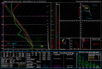
As long as the parameters are met season wouldn't seem to be a big issue; with near 100kt 700mb winds and unseasonably high dew points I'd say we've got a good shot at hitting derecho qualifications somewhere.

On that note, if those parameters stay intact I fully expect a 45/hatch moderate risk for wind on Saturday. A derecho forecast usually calls for probs that high, though any uncertainty that a derecho may not develop would probably hold it at 30. The only real question at this point is the possibility for discrete development which might also up the tornado probs. Given the prolific tornado production of QLCS with hodos like are being modeled, even as high as a 10-15% would probably be a safe bet at the heart of the QLCS regardless of supercell development.

As I look at it today, I find it very hard to go with anything less than a moderate risk. This is looking like a classic mean one.
 

Equus

Member
Messages
3,346
Reaction score
3,532
Location
Jasper, AL
Special Affiliations
  1. SKYWARN® Volunteer
Yep yep, if warm sector starts looking more supercell-friendly, perhaps even a MDT for both wind and tornadoes. Have seen setups with far less scary dynamics go MDT after all
 

Richardjacks

Member
Meteorologist
Messages
1,161
Reaction score
1,331
Location
Atop Red Mountain Birmingham, Al
We aren't going to know the true supercell risk until Saturday morning, too many if's at play such as timing of the pivot and quality of warm sector, but the QLCS/derecho risk is quite high, regardless.
 

warneagle

Member
Messages
4,017
Reaction score
3,984
Location
Arlington, VA
Special Affiliations
  1. SKYWARN® Volunteer
Serial derechos, those that usually are generated by a squall line, are more common when jet dynamics are intense, e.g. in the cold season and early spring.
Yeah, warm season derechos are more of an upper Midwest phenomenon rather than a southern one. You’re much more likely to get sufficient dynamic support for a derecho event in the south in the cool season.
 

KoD

Moderator
Staff member
Moderator
PerryW Project Supporter
Sustaining Member
Messages
1,392
Reaction score
728
Location
Huntsville, AL
NWS Huntsville AFD said "forecast severe weather parameters are astounding"

HSV NWS said:
Will stay with a more consistent ECMWF overall system position location, which is slower than the faster GFS. But am going a bit weaker with the system like the GFS, as the ECMWF could bring a higher severe threat to the area if its forecast holds. In either case and accounting for timing differences, forecast severe weather parameters are astounding, especially for the winter, and would be really high in the spring. 850mb winds from the NAM/ Canadian/ECMWF were up into the 70-80kt range during Sat, yielding storm relative helicity values of 400 to over 800m/s at times. Dewpoint values were in the low/mid 60s for much of Sat, with highs later that day nearing 70. But CAPE values were a bit lower into the 50-150 J/kg range, at times above 300 (especially from the Canadian). Thus, all modes of severe weather are possible - especially damaging winds and tornadoes. A negatively tilted upper trough in conjunction with the deepening surface low could allow discrete convective cells with tornado production possible. A quasi- linear convective system/squall line like feature the models were hinting at would be another area with tornado development.
 

Kory

Member
Messages
4,928
Reaction score
2,119
Location
Tuscaloosa, Alabama
Interesting...there's certainly some level of threat there but I haven't seen anything I would call astounding yet, and the model agreement isn't great.
When you have 0-1KM helicity values in excess of 400 m2/s2 and 0-3KM values in excess of 600 m2/s2 across two states, that’s astounding. Some of the shear values are just absolutely bonkers. But, this may be a case where we will need sufficient stretching of the updrafts...I.e., tall CAPE profiles.
 

Kory

Member
Messages
4,928
Reaction score
2,119
Location
Tuscaloosa, Alabama
Im curious why no one is mentioning the pitiful lapse rates.
I don’t know if I’d consider 6.0-6.5 C/KM lapse rates pitiful (those are mid level of course). I think the surface-3KM lapse rates need some work, but a later arrival would certainly aid in low level destabilization.
 

ARCC

Member
Messages
503
Reaction score
309
Location
Coosa county
I don’t know if I’d consider 6.0-6.5 C/KM lapse rates pitiful (those are mid level of course). I think the surface-3KM lapse rates need some work, but a later arrival would certainly aid in low level destabilization.

12z Euro in central MS ahead of the line. Needs a ton of work.
 

Attachments

  • 48BB8DD7-4AF1-4FDC-B558-9AC38C8D6F69.png
    48BB8DD7-4AF1-4FDC-B558-9AC38C8D6F69.png
    238.8 KB · Views: 0

ARCC

Member
Messages
503
Reaction score
309
Location
Coosa county
It is assumed that low level temps will be higher than progged which will bolster the lapse rates...in this type of scenarios that assumption works out unless the warm sector gets contaminated

NAM doesn’t show any contamination, but largely the same except for the higher mid level temps. 0-3km cape is decently better.

1578519984194.png
 

ARCC

Member
Messages
503
Reaction score
309
Location
Coosa county
LR's are marginal in that sounding. However, CAPE is very sufficient.

Yes and no. It is sufficient for winter time severe storms, but the issue is the majority of it is off the surface due to the cap. If storms remain elevated the threat from both wind and tornadoes drops significantly.
 

Kory

Member
Messages
4,928
Reaction score
2,119
Location
Tuscaloosa, Alabama
Yes and no. It is sufficient for winter time severe storms, but the issue is the majority of it is off the surface due to the cap. If storms remain elevated the threat from both wind and tornadoes drops significantly.
I don’t think surface temps should be taken verbatim when we’ve seen them verify 3-5+ degrees warmer than the past couple events at this range on the models.

There is going to be some serious WAA going on Saturday as long as there isn’t junk convection in the warm sector.
 
Messages
508
Reaction score
556
Location
Canton, GA
Yes and no. It is sufficient for winter time storms, but the issue is the majority of it is off the surface due to the cap. If storms remain elevated the threat from both wind and tornadoes drops significantly.

There is an area of weak inhibition, however I don't see much on that sounding that would prevent a severe QLCS. WAA will be very strong and likely will change the near-surface parameters.
 
Back
Top