Gail
Member
30% hatched area on Day 3.

Follow along with the video below to see how to install our site as a web app on your home screen.
Note: This feature may not be available in some browsers.

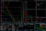
Does the 06z euro show warm sector cellular convection?IMO, this kicks it up another notch if the surface low is down to 998, in this position, and and strengthening to the NE.
**Update: 06Z has it down to 996 near LIT
View attachment 2276
Does the 06z euro show warm sector cellular convection?
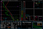
One thing that stands out to me is that this lower pressure is happening just before the system begins to tilt which tells me the strongest pressure falls are just beginning...so the pressure will likely go lower.IMO, this kicks it up another notch if the surface low is down to 998, in this position, and and strengthening to the NE.
**Update: 06Z has it down to 996 near LIT
View attachment 2276
where do you see this?The euro has a CAM resolution of the 06z which shows several supercells out ahead of the main line which is broken segments. Oh boy.
I’m with you. Not happy about what I’m hearing so far...I don't usually get storm anxiety anymore, but this setup has me pretty on edge if nothing backs down. Looks like even a failure mode would bring nasty winds with a statewide QLCS. Pretty high ceiling on this one.
Private chat on Discord.where do you see this?
I don't usually get storm anxiety anymore, but this setup has me pretty on edge if nothing backs down. Looks like even a failure mode would bring nasty winds with a statewide QLCS. Pretty high ceiling on this one.
the real issue with the 12z nam is that low level instability doesn't go as far north as has been shown by the Euro. It limits Td's in the upper 50's, 60's are further south. It this is true, it will be correct as the shear will tear apart the weak updrafts, but this goes against what we the models have been showing thus far.Shear profiles are more impressive over southern parts of MS/AL/the FL panhandle for Saturday, with adequate instability as early as 15Z (9 AM CST). Could be a nasty day for that area if this look holds up. There's a slight amount of VBV in this sounding but not nearly as much as progged by the NAM for Friday. IIRC the profiles looked similar going into 12/16.