• Welcome to TalkWeather!
    We see you lurking around TalkWeather! Take the extra step and join us today to view attachments, see less ads and maybe even join the discussion.
    CLICK TO JOIN TALKWEATHER

Iceland's Fagradalsfjall Fires

With a greater volume of magma down there now, if magma does break through to the surface, could the barriers hold it all back?

The Southern Volcanoes group points out a sign that's possibly hopeful in a post on Facebook (though I used Google Translate and did a screenshot for the image):

Changed pattern in the earthquake activity?
The earthquake activity at the Sundhnúk crater series in recent weeks seems to show a slightly different pattern from what has been seen so far between eruptions in the eruption chain.
In recent weeks, the seismic activity has been occurring just east of the crater series itself. The activity is therefore somewhat parallel to the activity that was seen, for example, before the last eruption. This is clearly seen in the accompanying images, which show different periods. The first image shows the activity over the last 30 days, while the second is the activity over the last month before the last eruption, which began on November 21.

It is completely uncertain what this means and it is unlikely that much can be concluded from this changed pattern. If an eruption fissure were to open so far east, it would probably be good news for Svartsengi, as the crater series from previous eruptions would significantly restrict the flow of lava to the west.

Otherwise, it's still a waiting game.

Yesterday there was a little swarm in the Sundhnuk region northeast of Grindavik, with one quake almost up to M2, but it’s quiet now on the vafri.is graphic.
 
Today IMO mentioned the eastward shift of seismicity in their update but attributed it to triggering and stress release rather than a new site of magmatic activity (though they did not rule out that possibility).

The Southern Volcanoes group mentioned on Facebook that another focus of seismic activity is occurring south of Hagafell (the mountain from which we watched the explosions via cam that one time). That's closer to Grindavik, and presumably the ground cracks that would funnel lava from the Hagafell area into unexpected places are still open, but IMO notes that eruption here is unlikely and that there should more warning -- hours -- before any eruption there.

They still say, if eruption occurs, it will be in the same general area as recent ones, but likely without much warning -- maybe 30 minutes, if they're lucky.

This is quite a scenario: the sill's estimated volume now is greater than it has been since these eruptions began. Southern Volcanoes group notes that initial flow rates in the last eruption were in a quite respectable range of 2,000 m/s.

If it occurs (versus a dike intrusion), the next eruption's start will be spectacular and very dangerous to the neighborhood.

Both expert groups note that any new eruption also will probably be larger in volume than the last one, which was the biggest thus far.

Per IMO via GT:

What can we expect in the next volcanic eruption?​


It is most likely that magma will first erupt between Sundhnúkur and Stóra-Skógfell, as has happened in six of the last seven eruptions since the end of 2023. The fissure could then spread northeast and/or southwest for several kilometers. Such eruptions could occur with very little or no warning.

However, there is nothing in the measurement data to rule out the possibility of an eruption occurring near or south of Hagafell, as was the case with the eruption in January 2024. The warning period for an eruption starting at Hagafell would be longer, approximately 1 to 5 hours. The longer warning period depends on how far south the magma erupts before reaching the surface. Approximately 4.5 hours passed from the first signals on January 14 until the eruption began. An increase in seismic activity is likely if the magma travels this route.
 
After a long stretch out of the spotlight, we hear again from Thorvaldur :) -- who as Dr. Thordarson is a world-renowned volcanologist, by the way, and an authority on Laki, Iceland's last flood basalt eruption, which began in June 1783.

Sundhnúkaeldar singing their last​

Þorvaldur says that although the volcanic season on the Reykjanes Peninsula is just beginning and will last for the next 200-300 years, there are many indications that the volcanic eruptions at Sundhnúkagígar are coming to an end.

"The Fagradalsfjall fires lasted for about two years and then the activity shifted to Sundhnúkar a little over a year ago. These two eruptions are different in many ways, for example, we didn't see as much land rise at Fagradalsfjall. This ongoing eruption swarm is nearing its end. I therefore firmly expect the Sundhnúkar fires to end this year."

The activity indicates that magma is accumulating.​

Þorvaldur says that the next swarm could start at any time and it is not clear where or when it will happen. Last night, an earthquake swarm began west of Kleifarvatn, which may indicate that magma is accumulating there.

-- Source (autotranslated)

IMO's Benedikt said in an interview the other day that he thought there would be just one more eruption in this area, though it can't be guaranteed.

I saw in the news, too, where Armann, another media volcanologist favorite in Iceland, also thinks it's almost over here. He is still saying the next series will be in the volcanic systems to the west of the Fagradalsfjall and Sundhnuks "systems" (not formally defined as such but definitely field-proven over the last four years), whereas Thorvaldur's "west of Kleifarvatn" is actually east of the current activity, where there are at least three volcanic systems for the boffins and volcanophiles to speculate about.

Not sure, but I think that all these areas, west and east of the Fagradalsfjall-Sundhnuks area, are much more sparsely populated, though there are geothermal plants, either way. That's a relief.

It's nice to see the experts in general agreement, but first, let's get this current issue settled, preferably not with an eruption, although that seems a forlorn hope.
 
Well, this is unexpected (except, perhaps, for Armann): there is an unusually intense swarm of quakes -- intense enough for mbl.is to point out (autotranslated) that it isn't an eruption -- going on about ten miles west along the coast from Grindavik.

IMO has only made a geoscientist statement this far, written about half an hour ago (via GT):

Today, March 12. at 14:30 an earthquake swarm began in Reykjanestá, about 190 earthquakes have been measured and the activity continues. Three earthquakes of about and above magnitude 3, the largest magnitude 3.4. A more detailed review is being carried out and these magnitudes could change. The earthquakes have been found in Gríndavík. The last earthquake swarm was outside Reykjanestá at the end of December 2024 when earthquakes of a similar magnitude were measured. At that time, the seismic activity was located near Eldey about 10 km SW of Reykjanestá, where the activity is now. Since 2023, five earthquake swarms have occurred in the same area as the current activity. In addition, there have been considerable swarms there in 2021 and 2022, for example. The earthquakes are possibly triggered by changes in the stress field on the Reykjanes Peninsula, in conjunction with earthquakes there in recent years.

Written by geoscientist on duty 12 Mar. 18:59

AFAIK, that area has at least one geothermal area, even hotter than Svartsengi's, called Reykjanes (appropriately since it's on the tip of the peninsula of that name).

There is an associated volcanic system -- fissures that have erupted the same general type of lava in the past. It's also called Reykjanes, and what it includes depends on which expert you consult.

IMO and the Catalog take a minimalist view and include most volcanism in that area in it.

Others, including Armann, I think, do not, but let's not get distracted by academic details about it.

Another system in the area of today's swarm is Eldey, which has had considerable but brief seismicity off and on throughout the Svartsengi eruptions period.

Eldey is mostly submarine and eruptions occur there but aren't necessarily detected. IMO recently put equipment on Eldey rock, offshore, but I've seen no further mention of that.

It's fascinating that the seismicity has moved northeast. An eruption here in shallow water could produce Surtseyan plumes and tephra, widening the impact, though gases might be a little less problematical in this scenario.
 
As for local effects, the tip region is where videographers get most of their wilderness shots of the Reykjanes Geopark.

In this video, Eldey rock appears shortly after the 7-minute mark, as credits start up.


That said, there is an important road around the peninsula, and also, Surtseyan activity would probably cause ashfall in inhabited regions, perhaps even in Reykjavik if the winds cooperated.
 
Southern Volcanoes group notes on Facebook that the swarm is ongoing but less intense and might be slowing down. They see no sign of magma movement. (They, too, take the minimalist view and consider Reykjanes and Svartsengi one system.)
 
Magnus Tumi on the eruption. (Icelandic)

He isn’t saying much new, except that the scope of the next eruption is likely to be similar in size to previous ones.

What he is doing, though, is keeping public attention focused on a very serious volcanic threat. Such crises are drawn out and public weariness/inattentiveness is a challenge that volcanologists mention again and again in their papers.

This is especially important now, when there could be little to no warning before a huge lava fountain breaks through the ground. Everyone still needs to be on their toes 24/7 until the threat either materializes or definitely is over.
 
This RUV article (autotranslated) is actually about a volcanic system north of Reykjavik, but they do point out that there conceivably could be a connection between it and Fagradalsfjall, though what that might be is another question.

It's a terrific and in-depth article for anyone who is curious about Iceland and interested in volcanoes. There is some beautiful photography, too

For instance:

Despite the earthquake at Grjótárvatn, Snæfellsjökull is quiet. Kristín says the Icelandic Meteorological Office has had meters there for many years. "We have never seen any activity there, except for the occasional small earthquake," she says. "There is nothing to indicate that anything is happening there."

But there is no indication that the seismic activity at Mýri is abating, almost four years after it began.

Páll wrote a research report on the earthquakes for the Icelandic Meteorological Office, which he submitted in March. In it, he presents different scenarios of what could happen.

The first scenario, he says, is that the activity simply dies out and nothing more happens.

"The next one is that the magma reaches the point where it starts to break through somewhere, forming a magma channel," says Páll. "But it could completely stop in the middle of the action and give up."

"Then there's the third scenario, where a tunnel like this reaches the surface and there's a volcanic eruption."
A picture of the Ljósufjöll mountains on Snæfellsnes Peninsula. The mountains are covered in snow.

Ljósufjöll on Snæfellsnes Peninsula.
RÚV – Ingvar Haukur Guðmundsson


It is completely uncertain how long the lead time for an eruption would be. But if an eruption does occur, Páll believes the most likely scenario is that it will occur somewhere in the valley floor near the source of the earthquakes.
 
There have been two earthquake swarms north of Grindavik this month, one on the 11th and one a few days ago, but the Reykjanes Ridge is staying tight shut.

Media webcams (RUV, Visir, mbl.is) are all updated, and IMO is issuing more frequent updates, though there really isn't anything new to say at this point in the waiting game. Still, today, for example:

A new eruption at the Sundhnúk crater series must still be expected.​

The volume of magma under Svartsengi has never been greater since the eruption began in December 2023​

25.3.2025

Updated March 25 at 2:15 PM


  • Magma accumulation continues, but the rate of landslip has slowed in recent weeks.
  • The most likely scenario is that this magma accumulation period will end with a magma flow and/or volcanic eruption that would first occur in the area between Sundhnúkur and Stóra-Skógfell.
  • Seismic activity has slowly increased in recent weeks, indicating that pressure at the eruption sites is increasing.
  • A volcanic eruption must be expected at very short notice.
  • Risk assessment remains unchanged
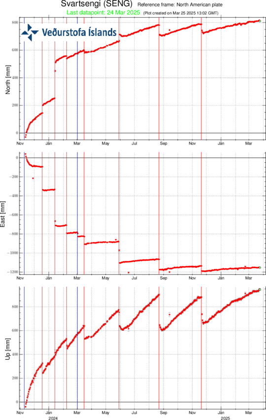
Deformation measurements (GPS) show that magma accumulation under Svartsengi continues, although the rate of land uplift has slowed slightly in recent weeks. Despite the slower land uplift, it is still considered likely that magma flows and/or volcanic eruptions will occur at the Sundhnúk crater series.

The size of a potential eruption depends on how much magma escapes from the magma chamber when an eruption begins. The volume of magma has never been greater since the eruption of the Sundhnúk crater series began in December 2023, and it is therefore possible that the next eruption will be larger in volume than the previous eruption. It is believed that magma would most likely first emerge in the area between Sundhnúk and Stóra-Skógfell. This has been the case in six of the seven eruptions that have occurred since the volcanic activity began in late 2023. The exception is the eruption that began in January 2024, when magma first emerged just south of Hagafell.

BED-plate_since-25032025

Records of GPS station SENG in the Svartsengis area since 11 November 2023 in the north, east and vertical directions (top, middle, bottom). The bottom curve shows the land rise in millimeters, and yesterday's measurement (24 March) is shown with a green dot. The red lines are the timing of the beginning of the last seven eruptions (18 December 2023, 14 January, 8 February, 16 March, 29 May, 22 August and 20 November 2024). The blue lines represent the timing of magma flows that have occurred without an eruption (10 November 2023 and 2 March 2024).

Seismic activity has been slowly increasing in recent weeks. Due to repeated events in the Sundhnúk crater series, where magma tunnels and fissures have formed, the tension in the earth's crust has decreased with each event. This means that fewer and smaller earthquakes are measured in the area in the weeks and days before an eruption than they did in the run-up to the first eruptions. Very short notice is required for an eruption, but in the last two eruptions, only about 30–40 minutes passed from the first signs of the earthquake swarm until the eruption began. The signs that have been seen when magma seeks the surface are intense small earthquake swarms in the Sundhnúk crater series, pressure changes in HS Orka's boreholes in Svartsengi, deformation of fiber optics, and deformation of the surface seen in real-time GPS measurements.

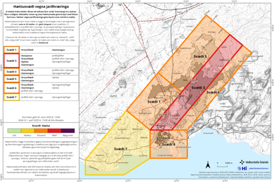
The hazard assessment remains unchanged and is valid until April 1st, with everything else unchanged. See also what to expect in the next eruption at the same link.

Haettusvaedi_VI_25March_2025

If and when magmatic pressure overcomes tectonic pressure, things could be spectacular and, depending on where it occurs, very destructive.

IMO also did a post (autotranslated) about their outlook on future volcanism on an awakening Reykjanes Peninsula. To this layperson it's an excellent statement in lay terms of volcanology's knowledge and uncertainties regarding this region.
 
RUV reports (autotranslated) that IMO has picked up warning signals and Civil Protection is moving.

The vafris.is graphic is wild:

screenshot_20250401-001557_firefox-focus.jpg

That extension offshore is interesting.

Checking the cams...
 
Magma is on the move but it hasn't reached the surface yet. Grindavik is evacuating. Blue Lagoon is cleared. Most likely location of eruption would be in the same general area, which is not good if this is a really high-volume event.
 
Uh oh:

screenshot_20250401-004612_firefox-focus.jpg
 
I haven't seen any media updates since those large ones -- 4.2 tops thus far, per vafri.is -- began; it seems to be associated with Eldey, farther west and offshore.

No updates more recent than about half an hour ago from IMO, either (autotranslated).

Is this another plate boundary movement? I hope everyone is okay.
 
Got a little panicky there, but now updates are posting and people seem to be taking it in stride, though this is different from recent starts. Many of the 3-pointers are from Svartsengi. Magma is still underground at this point.
 
RUV per GT: "

Seismic activity is moving south​

Seismic activity is moving south, says Jóhanna Malen Skúladóttir, a natural hazard expert. Seismic activity has usually been highest between Sýlingarfell and Stóri Skógfell, and that's where the most recent eruptions have occurred, but now the activity is moving south towards Sundhnúk and is highest between Þorbjarn and Sýlingarfell, near Grindavík. A volcanic eruption could occur there.

150 earthquakes have occurred since the magma flow began at 6:30 am. Many of them are over 3 in magnitude."
 
RUV's mosaic includes the IMO live fiberoptic seismogram -- can't say anything intelligent about that except that it's usually not yellow.

screenshot_20250401-011757_youtube.jpg


Meanwhile, it's morning rush hour and people are parking along the main drag between Reykjavik and Keflavik in hopes of catching the start of an eruption -- pity the seismicity is moving south away from them, but then again, "main drag." Might be a blessing in disguise for that area, at least.
 
I was worried about this possibility when I saw that offshore extension:

RUV via GT: "

Feeling tremors in the town and signs of deformation there​

The signals from the deformation sensors are stronger than those seen in recent events at the Sundhnúk crater series. This indicates that a considerable amount of magma is on the move.

The signs that are visible show that the magma is moving both to the northeast and also to the south towards Grindavík. At this stage it is not possible to say where the magma will emerge, but the movement of deformation signs to the south was not seen, for example, during the eruption that began in November 2024.

Emergency responders in Grindavík say they are feeling earthquakes in the town and there are also signs of deformation, making it possible that cracking could be occurring within the town.
 
Same source, emphasis added -- basically, the dike is opening both north and south, and the magma has not yet begun to rise into shallow levels (subside, in the translation below); apparently there is some question about what is feeding this run --

"

Clear signs of opening in both directions​

The seismic activity is moving south and north, says Benedikt Ófeigsson, and there are clear signs of opening in both directions on the Sundhnúk crater series.

This is a bigger event than the last one compared to the beginning. There is a bit more going on in Grindavík than last time, people are feeling earthquakes there for the first time in over a year.

There is still a chance that the magma will not reach the surface. The earthquakes are still quite deep and have not started to subside. This means that the magma has not started to approach the surface.

Now we just need to pay close attention to how far north and how far south the event goes and try to figure out when the earthquakes start to subside and try to deduce from that where the magma is coming from."
 
From mbl.is (autotranslated):

"...Jóhanna says that the most common source of the eruption was in the area between Sýlingafell and Stóri Skógfell, but given the current seismic activity, it cannot be ruled out that the magma will erupt further south, closer to Grindavík or further north.

"As we have talked about, we have been expecting a very short reaction time when the eruptions have occurred between Sýlingarfell and Stóri Skógfell. Now the magma seems to be trying to look in other directions and as a result it may be more difficult for it to reach the surface. This is taking longer and only time will tell whether it will reach the surface. From previous experience we expect this scenario to end with an eruption," she says."
 
No updates yet. The swarm continues but there aren't as many 3-pointers recently on the vafri.is graphic. The Eldey area quakes perhaps are triggered. Visir has live coverage, too (autotranslated).
 
Back
Top