• Welcome to TalkWeather!
    We see you lurking around TalkWeather! Take the extra step and join us today to view attachments, see less ads and maybe even join the discussion.
    CLICK TO JOIN TALKWEATHER
  • April 2024 Weather Video of the Month
    Post your nominations now!
Logo 468x120

Iceland's Fagradalsfjall Fires

bjdeming

Member
Sustaining Member
Messages
1,784
Reaction score
1,490
Location
Corvallis, Oregon
Michael Bay, call your office.

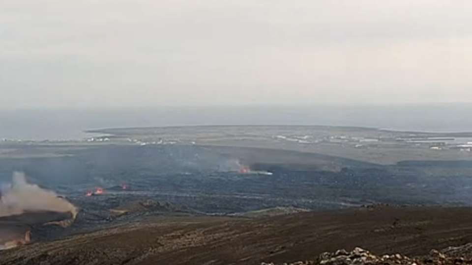
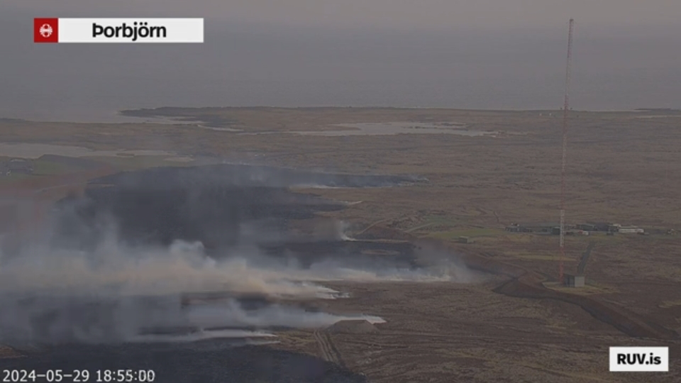
There must be quite a large groundwater body down there. I wonder about the color difference -- that tan plume closest to the camera might have a very high sulfur content, adding toxicity to the particle hazards from all this (which include interference with the electrical grid from very fine ash, though this is to the east, fortunately).

Over on the west, it looks like lava has crossed the road and is heading into the plant/Lagoon complex. Spokespeople say the new hot water pipe is fully shielded -- this time, that likely will be tested.
 

bjdeming

Member
Sustaining Member
Messages
1,784
Reaction score
1,490
Location
Corvallis, Oregon
Wait. The newer fissures are showing explosiveness now -- away from the mountain (at whose feet one would expect groundwater to collect), a little closer to the sea. And recall the water that would-be rescuers found in cracks when that one worker disappeared. I hope this isn't coming up from depths below that water layer, i.e., from the November 10th dike itself...

Update: Apparently not; the explosions have died down quite a bit since fissure openings moved southward. Whew!
 
Last edited:

bjdeming

Member
Sustaining Member
Messages
1,784
Reaction score
1,490
Location
Corvallis, Oregon
Visir cam shows the barriers holding, north and west thus far:

screenshot_20240529-092539_youtube-2.jpg
 

bjdeming

Member
Sustaining Member
Messages
1,784
Reaction score
1,490
Location
Corvallis, Oregon
University of Iceland experts, about half an hour ago (Facebook translation): 1,500-2000 cu m/sec flow , geothermal explosions, something seems to be slowing down the older fissures, they say, but new ones are still opening south toward Grindavik.

RUV reports the citizens have left; responders are still there.

A little perspective: Iceland does have flood lava eruptions every millennium or so (last in 1783-84) but those flow rates are more like 5,000 to 7,000 cu m/sec and volumes are tens of cu km. As Magnus Tumi told reporters, there was only 0.020 cu km down there today, total.
 
Last edited:

bjdeming

Member
Sustaining Member
Messages
1,784
Reaction score
1,490
Location
Corvallis, Oregon
RUV, a minute ago:

Complete evacuation of Grindavík nearing completion​

Úlfar Lúðvíksson, police chief in Suðurnes, outside Efstaleiti 1.
RÚV / Guðmundur Bergkvist
Úlfar Lúðvíksson, police chief in Suðurnes, says the complete evacuation of Grindavík is about to end. There are no residents left in the town, but it had been reported earlier today that three residents refused to leave the town.

Responders are leaving town now.
This is due to increased uncertainty about the progress of the eruption, which Úlfar says cannot be ruled out that it can extend closer to the town. At the same time, the roads in and out of town are being closed one by one. Lava has already flowed over Grindavíkurveg and Norðurljósaveg, and there is a high probability that Nesvegur will be closed soon.
 

bjdeming

Member
Sustaining Member
Messages
1,784
Reaction score
1,490
Location
Corvallis, Oregon
Benedikt (from RUV via GT):

Deformation measurements show that deformation was very fast to begin with, during the first two hours, according to Benedikts.

He hopes the flow is stabilizing as the deformation is decreasing.

Deformation is what happens in the Earth's crust on either side of where the magma comes to the surface. There the earth's crust is pushed and displacement occurs. Bendedikt says that when the magma flows up, it does not need more volume and then the deformation is reduced. "Which tells us that there is a balance in the flow from below and up to the surface." It does not mean that the eruption is stopping, but that it has stopped increasing, it is reaching a constant flow."

Presumably, it will then be reduced as time goes on.
 

bjdeming

Member
Sustaining Member
Messages
1,784
Reaction score
1,490
Location
Corvallis, Oregon
RUV again, emphasis added:

Grindavík could be closed by the land route tonight - "The situation is not good at the moment"​

"Lava is flowing outside the defense walls at Grindavík in several places, and lava is also starting to flow outside the defense walls at Svarstengi. It tests both the parks to the west and east of the town and the parks at the US Navy's radio station, which is northwest of Grindavík," said Víðir Reynisson from the Public Defender's Office in an interview on Rás 2 a while ago.

Lava also flowed over one of the gardens, which had become filled with lava from the previous eruption, and it approached the ramparts that had been made in addition.

...

"Grindavík will be closed off by land if lava flows to Suðurstrandarvégur." Víðir does not think it is unlikely that it could happen tonight if the lava flow continues at the same speed.

There is always a risk of lava flowing into Grindavík during a volcanic eruption​

"The biggest lava flow is at the communications center right now." Most of the high voltage lines are gone, the masts are badly damaged and some are on fire."

The dark smoke rising from the eruption earlier was lava coming into contact with groundwater at Hagafell. Víðir says this can happen again as there is a lot of groundwater there.

Afraid that lava will flow into Grindavík?

"Yes, let's do it, of course, there's always a risk when it's like this." The houses in the west and farthest part of the town would have gone under the lava if it weren't for the ramparts, but they are still standing and defending. But there is also the possibility that if lava flows in large quantities south of the gardens, it could potentially enter the western and southernmost neighborhoods of the town. Hopefully not."

Víðir Reynisson, Katrín Jakobsdóttir, Fannar Jónasson and Kristín Jónsdóttir at the information meeting of Almannavarna 20.12.23.
Vidir Reynisson.RÚV / Ragnar Visage

The next few hours into the night are extremely important...
 

bjdeming

Member
Sustaining Member
Messages
1,784
Reaction score
1,490
Location
Corvallis, Oregon
It does seem like the ends of the fissure line are petering out while this central section continues (those southern fissures are awfully close to town, though).

Does it end here in a day or two, or do we get another extended eruption?
 

bjdeming

Member
Sustaining Member
Messages
1,784
Reaction score
1,490
Location
Corvallis, Oregon
RUV's latest report: Lava appears to be coming up right next to the US Navy's radio station (but outside its defenses) on this cam:


That's time dependent so here is a screenshot:

screenshot_20240529-115231_youtube.jpg


According to IMO spokespeople interviewed:

Einar Hjörleifsson, a natural disaster expert at the Icelandic Meteorological Office, says they have been watching lava coming up there for almost an hour now. It is the opinion of the Norwegian Meteorological Agency's scientists that lava is coming up there, flowing into a fissure elsewhere and rising there again. Therefore, it is probably not really a new eruption.

"We can see this clearly on webcams and we are closely monitoring this. We will continue into the night."

Einar says they are also closely monitoring the progress of the lava in other areas. Now attention is focused, among other things, on a pond called Silfra in the west of the town. If lava flows into it, explosions and igneous formation in the interaction of magma and water can be expected.

(Why Google translates it as "Icelandic" in one sentence and "Norwegian" in another is beyond me.)
 

bjdeming

Member
Sustaining Member
Messages
1,784
Reaction score
1,490
Location
Corvallis, Oregon
Apparently it didn't get to that lake west of Grindavik that they were concerned about, which is good -- no explosions.

A small vent opened up around 10 p.m. local time near Sylingarfell, which is a change in pattern, but it isn't producing much. Visibility is really poor on the cams just now, but there reportedly are just a few fountains left, in that central area, and the lava is heading north. Grindavik seems to have gotten a break.

Also the south coastal road into town is still open.

I mistook roads on the cams earlier, thinking a view of lava eating asphalt was on the highway leading into the plant complex -- it was another road and, from the news, the lava has yet to cross that road and head toward the plant.

We'll hear more in coming hours about whether this roughly 14-million-m3 subtraction made the Svartsengi sill deflate (short eruption) or if it's maintaining (longer duration -- what Benedikt was talking about, basically).
 

bjdeming

Member
Sustaining Member
Messages
1,784
Reaction score
1,490
Location
Corvallis, Oregon
The plain subsided almost half a foot!

IMO is keeping all doors open with their new update (note: the machine translation gets really problematical in terms of discussion of gas effects towards the end; I suspects "snowstorms" refers to gas effects but will try to find clarification in news articles):

Updated May 30 at: 12:20 p.m


  • Significantly reduced the activity of the eruption
  • Lava flows mainly in the area around Hagafell
  • No explosive activity since yesterday afternoon
  • GPS measurements show that the land in Svartsengi softened by 15 cm when the magma ran from there.
  • Possible gas pollution in the South today and in the capital area in the afternoon and tomorrow. Gas distribution forecast available here
  • Considerable uncertainty about the amount of gases from the eruption sites. Real-time measurements of air quality available on the Environment Agency's website.

Since yesterday afternoon, the activity at the volcanic fissure at the Sundhnúks crater series has decreased significantly. The activity in the eruption has been on a similar note last night and this morning, but the eruption turbulence has been constant since late last night. No explosive activity has been seen since yesterday afternoon, but steam explosions occurred as lava flowed into cracks and came into contact with groundwater at Hagafell. Activity is closest to the crater that was the longest active in the eruption that began on March 16, and activity in several parts of the fissure north of it. The lava flow is now greatest in the area around Hagafell. The flow of lava has slowed down along Grindavíkurveg towards Svartsengi and at the defenses west of Grindavík.


Experts from the imaging team of the Natural History Institute and Iceland's National Land Survey went on a survey flight over the eruption centers. The conditions for aerial photography were challenging as the plume covered part of the lava bed that was formed at the beginning of the eruption. The data obtained during the aerial photography flight are being further processed together with the use of satellite images in order to get a clearer picture of the lava flow during the first hours of the eruption. The accompanying map shows the roughly approximate contours of the lava bed, as they were around 17 yesterday, or when the eruption had been going on for over four hours. The location of the eruption also shown with red dashed lines.


Extension30052024


The land in Svartsengi softened by 15 cm when magma ran from there​


Satellite images taken early this morning, May 30, do not show significant movements of cracks within the defense walls at Grindavík. Real-time deformation measurements also show that since last night no significant deformation has been detected there.


GPS measurements show that the land in Svartsengi softened by 15 cm when magma ran from there into the Sundhnúks crater series yesterday. The magma corridor that formed and now feeds the eruption stretches from Stóra-Skógfell to Hagafell. It is estimated that around 15 million cubic meters of magma have already been removed from the magma collection area under Svartsengi.


Measurements over the next few days will provide more information on the development of magma accumulation under Svartsengi and the possible development of the eruption. The National Weather Service continues to monitor the area and monitor the development of the event.
 

bjdeming

Member
Sustaining Member
Messages
1,784
Reaction score
1,490
Location
Corvallis, Oregon
From the new RUV live coverage (autotranslated), I think they're talking about this haze, which was visible even though there wasn't enough pollution from it to set off alarms.

Blámoða over the North and East​

The Norwegian Meteorological Agency has received reports from both Norðfjörður and Mývatn Sveit that blue haze from the volcanic eruption is over there. Rúnari Snæ Reynisson, our reporter from the east, has also received suggestions to photograph from Jökuldal, where this picture was taken.
Photo of blue haze in Jökuldal due to the volcanic eruption on the Reykjanes Peninsula.
Submitted photo / Jón Björgvin Vernhardsson
Photo: Jón Björgvin Vernhardsson.
The Norwegian Meteorological Agency says that the haze can be measured on the Environment Agency's pollution meters both in Reyðarfjörður and at Húsavík. The pollution is small but clearly visible.
 

bjdeming

Member
Sustaining Member
Messages
1,784
Reaction score
1,490
Location
Corvallis, Oregon
Not much change in the eruption; most activity is located at and around the March 16th crater, reportedly, though I don't know if or when that awoke after dying out on the 9th.

Benedikt told reporters that it's too early to tell if landrise has begun again but that he would be very surprised if it hadn't.

Fortunately for Iceland, that blue haze wasn't intense enough to be toxic because it has covered the country (autotranslated).

Things were different, not only in Iceland, but for everyone living north of about 35°N in the 1780s (highly cited science paper on atmospheric effects). It isn't just air traffic that Icelandic volcanism can mess up (though such big eruptions are rare, as mentioned).
 
Back
Top