Gold as always from Trey
Navigation
Install the app
How to install the app on iOS
Follow along with the video below to see how to install our site as a web app on your home screen.
Note: This feature may not be available in some browsers.
More options
-
Welcome to TalkWeather! We see you lurking around TalkWeather! Take the extra step and join us today to view attachments, see less ads and maybe even join the discussion. CLICK TO JOIN TALKWEATHER
You are using an out of date browser. It may not display this or other websites correctly.
You should upgrade or use an alternative browser.
You should upgrade or use an alternative browser.
Hurricane Hurricane Milton
- Thread starter KevinH
- Start date
tornado examiner
Member
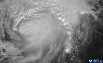
There was one video of Milton that i’d like to find and it showed what appeared to be the entire compact storm from Mexico. During sunset with a lot of lightning. Very surreal view.
Casuarina Head
Member
@JPWX I’ll give you credit for pointing out this season’s potential. 2024 really stood out in that more than half of its TC activity (11/18 storms, or 61%) took place after the “climatological” peak of the season, including four of its five majors. I certainly did not expect that. ACE-wise the season did end up crossing the “hyperactivity” threshold, with 161 units, though barely. So both CSU’s call for ACE of >200 units and my own for ≤149 Atmospheric Anti-Climax. But in the end impacts rather than statistics matter more for the public, and rightly so. Most of the worst storms this year were homegrown begin with, being west-based; I fixated too much on the MDR and SSHS categories (this year’s most adverse effects were mostly unrelated to wind, at least in the U.S., being attributable instead to, e.g., tornadoes, surge, and flooding).What the 2024 Atlantic Hurricane Season has shown us is that we've got to move away from the expected total numbers. I didn't use to see it that way, but I do now. Hits and impact wise has verified this season. The public runs towards the total numbers and expects that. We all do. You saw everyone throw their arms up and say this season is a Forecasted Convective Amplification Deficiency after we moved into the unfavorable MJO phases after Ernesto. I tried my best on here to get the point across that this season ain't over, but frankly, got shot down as to the main reason why it got inactive for a time. I'm already looking at doing a more probabilistic approach going forward for seasonal forecast instead of the whole numbers (Guilty as charged with going overboard on the total numbers this season). Funny thing is we've stayed in Neutral ENSO all season long and a spreadsheet I did up showed the Gulf coast states have more impacts during ENSO Neutral than La Nina.
Steps off soapbox
Casuarina Head
Member
@Sawmaster I was looking at the rating for the Sylvan Shores EF2 (130 mph) in Highlands Co. and noticed the following:Courtesy of Florida's new codes with strict inspection and enforcement of the same. It did mighty well for 140MPH, didn't it? Similar should be done in 'Tornado Alley" areas, but that ain't happening yet.
The bolded data seem to fit an upper bound of 112 mph for either single- or double-wide mobile-home DODs. At least half the walls seem to have been left upright and only partial roof loss seems to have occurred (maybe I’m reading too much into the info). So why did NWS Tampa go with 130 mph? Did the code have something to do with the wind?Approximately 20 to 30 units
suffered damage, primarily consisting of carports being peeled
off or removed, along with various degrees of roof, carport and
patio damage. A few units suffered partial wall collapses as a
result of the roof being compromised, with 1 injury as a result
when a woman sheltering inside her bedroom was injured by a
collapsing exterior wall. One unit was found to have been
displaced approximately one foot off its supports, along with its
roof mostly removed and a few walls collapsed.
NWS Miami assembled a beautiful ArcGIS presentation of the South Florida tornado outbreak from Milton.

 storymaps.arcgis.com

Hurricane Milton
A detailed analysis on the tornado outbreak and other impacts felt across South Florida during Hurricane Milton's closest passage to the region on October 9th, 2024.
