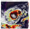
• Welcome to TalkWeather!
    We see you lurking around TalkWeather! Take the extra step and join us today to view attachments, see less ads and maybe even join the discussion.
    CLICK TO JOIN TALKWEATHER

Hurricane Hurricane Milton

00z GFS maintains an ugly scenario for Tampa Bay.
A little faster than 18z and tick south, landfall near New Port Richey. Little weakening before landfall and a large wind field.

Things are gonna have to change fast to avoid a major disaster in Tampa Bay.
 
A big slow down trend noted on the operational models runs today versus yesterday and earlier prior runs. Much further south and west for 1am Tuesday. Basically closer to the NHC point forecast for 7pm Monday.

Notice the 18z EURO ensemble plots through 1AM Tuesday in comparison to the current NHC forecast.

6325805D-D59C-47A8-8BC8-581690C7B352.jpg
F8DBF148-46AC-48EC-A515-95EF85890FAB.jpg
 
Last edited:
With the new recon data, Hurricane models are not backing off on intensity at all. In fact, HAFS A/B both show sub 900mb systems at around hour 48 and stronger systems closer to Tampa.

This is getting worse and worse.
 
12z GFS Oct 5th= Clearwater 9AM Wednesday
00z GFS Oct 6th= Clearwater 8AM Wednesday
12z GFS Oct 6th= Crystal River 7PM Wednesday
00z GFS Oct 7th= Crystal River 3AM Thursday

Assessment: Over a 100 mile landfall and 10-17hr time difference from today’s cycle versus yesterday’s.

12z GEM Oct 5th= Port Charlotte 9AM Friday
00z GEM Oct 6th= Saint James City 2AM Friday
12z GEM Oct 6th= Bonita Bay 8PM Thursday
00z GEM Oct 7th= Englewood 6AM Friday

Assessment: Consistent with southern end solution with landfall near Cape Coral region. Time is on the slower side with a late Thursday and early Friday landfall.

12z EURO Oct 5th= Madeira Beach 7PM Wednesday
00z EURO Oct 6th= Sarasota 2PM Wednesday
12z EURO Oct 6th= Holmes Beach 7PM Wednesday
00z EURO Oct 7th= Longboat Key 6PM Wednesday

Assessment: Most consistent with time of landfall. Also appears to waiver only around 60 miles with its most north and south hits with most hits into the Bradenton region.

8FDA0804-CFDE-4EBC-802C-B9D45AA80ACE.png
 
Last edited:
I just came back to Kansas City after visiting home in Fort Lauderdale, and I also made a stop in Tampa Bay for the Buccaneers game. I'm honestly shocked about the seriously devastating impacts Milton poses to the West Coast of Florida, especially the impacts this will have on tens of thousands of people struggling the Tampa Bay Area. Like Holy excrement Balls People!!!! This is a particularly catastrophic situation that may unfold.

People on the West Coast of Florida that can't economically survive a Cat 4 or 5 creeping towards them on trajectory that is forecasted for Milton after sustaining the impacts I've witnessed in areas stretching from Cape Coral to Clearwater. It'll just be too expensive cause prices of homes have increased, and construction materials have skyrocketed due to inflation. This is across the nation. I know this from building and renovating multifamily Apts in 30 states. There isn't even away for my company and our asset management clientele to save these communities by becoming owners/landlords/lenders/investors, because the high interest rates would push the risk profile to the point where the property could no longer afford being a rental. Instead, these homes and multifamily units would have to be renovated into AirBNBs for many areas to be commercially viable. This is pretty much what our clients have been doing, because it's the only way to cover expenses (insurance, financing) and construction by enough margin for investors to profit. This idea that Florida is uninsurable, either completely or entirely, due to climate change induced catastrophic hurricanes is merely a preferred political explanation that carries with it no definable solution.
 
Back
Top