I am still in the camp of non-OTS though.Don't even think for a second that a US impact is off the table. Remember Florence?
Navigation
Install the app
How to install the app on iOS
Follow along with the video below to see how to install our site as a web app on your home screen.
Note: This feature may not be available in some browsers.
More options
-
Welcome to TalkWeather! We see you lurking around TalkWeather! Take the extra step and join us today to view attachments, see less ads and maybe even join the discussion. CLICK TO JOIN TALKWEATHER
You are using an out of date browser. It may not display this or other websites correctly.
You should upgrade or use an alternative browser.
You should upgrade or use an alternative browser.
Hurricane Erin
- Thread starter wx_guy
- Start date
- Thread starter
- #42
wx_guy
Member
- Messages
- 1,204
- Reaction score
- 4,326
- Location
- United States
- HAM Callsign
- KO4ZGH
- Special Affiliations
- SKYWARN® Volunteer
- ARRL Member
I'm actually a bit confused -- the 0z best track position still has it at 16.3 N...but looking at the satellite, I can't possibly believe that. It looks to my eyes to be at 16N or maybe lower.
We haven’t gotten a good microwave pass yet to determine whether the satellite trend is valid, so I can see why 00Z stayed there. Should we get a pass I could guess we might see a revision of that point of the track.I'm actually a bit confused -- the 0z best track position still has it at 16.3 N...but looking at the satellite, I can't possibly believe that. It looks to my eyes to be at 16N or maybe lower.
majorhurricane1703
Member
I still don’t think it is moving WNW. It may be out of the NHC cone soon if that’s the case, because I agree with what you are saying.I'm actually a bit confused -- the 0z best track position still has it at 16.3 N...but looking at the satellite, I can't possibly believe that. It looks to my eyes to be at 16N or maybe lower.
- Thread starter
- #45
wx_guy
Member
- Messages
- 1,204
- Reaction score
- 4,326
- Location
- United States
- HAM Callsign
- KO4ZGH
- Special Affiliations
- SKYWARN® Volunteer
- ARRL Member
Just more observations.
5 PM forecast (8/11) for 2 AM Thursday morning:
FORECAST VALID 14/0600Z 17.8N 47.0W
5 AM forecast (8/12) for 2 AM Thursday morning:
FORECAST VALID 14/0600Z 17.4N 46.8W
5 PM forecast (8/12) for 2 AM Thursday morning:
FORECAST VALID 14/0600Z 16.6N 46.8W
5 AM forecast (8/13) for 2 AM Thursday morning:
FORECAST VALID 14/0600Z 16.5N 47.1W
5 PM forecast (8/13) for 2 AM Thursday morning:
FORECAST VALID 14/0600Z 16.3N 47.2W
We're about 4 hours from that point, wonder what latitude it'll be at...
Cyclonic Paracosm
Member
majorhurricane1703
Member
Just more observations.
5 PM forecast (8/11) for 2 AM Thursday morning:
FORECAST VALID 14/0600Z 17.8N 47.0W
5 AM forecast (8/12) for 2 AM Thursday morning:
FORECAST VALID 14/0600Z 17.4N 46.8W
5 PM forecast (8/12) for 2 AM Thursday morning:
FORECAST VALID 14/0600Z 16.6N 46.8W
5 AM forecast (8/13) for 2 AM Thursday morning:
FORECAST VALID 14/0600Z 16.5N 47.1W
5 PM forecast (8/13) for 2 AM Thursday morning:
FORECAST VALID 14/0600Z 16.3N 47.2W
We're about 4 hours from that point, wonder what latitude it'll be at...
The NHC at 11 pm elected to keep it at 16.3 N. Don’t understand that. It definitely is not higher than 16.1 N.
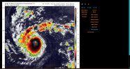
That’s certainly an ominous look.View attachment 45998
I cast, this does not look good, wow its gonna look insane come morning
Cyclonic Paracosm
Member
- Thread starter
- #50
wx_guy
Member
- Messages
- 1,204
- Reaction score
- 4,326
- Location
- United States
- HAM Callsign
- KO4ZGH
- Special Affiliations
- SKYWARN® Volunteer
- ARRL Member
The plot is now outside the NHC from 48 hours ago.
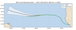
The NHC Cone goes out 67 miles at 48 hours, so we see over the past 24 hours, the trend has been outside the 48-hour cone, with the storm to the south about 70-80 nautical miles, This is 85-90 statute miles.
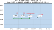
If the trend continues, Puerto Rico may be in play.

The NHC Cone goes out 67 miles at 48 hours, so we see over the past 24 hours, the trend has been outside the 48-hour cone, with the storm to the south about 70-80 nautical miles, This is 85-90 statute miles.

If the trend continues, Puerto Rico may be in play.
That’s very concerning. Also seeing shifts to the west too so we will need to pay even closer attention to this storm.The plot is now outside the NHC from 48 hours ago.
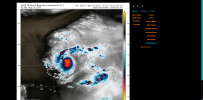
View attachment 46000
The NHC Cone goes out 67 miles at 48 hours, so we see over the past 24 hours, the trend has been outside the 48-hour cone, with the storm to the south about 70-80 nautical miles, This is 85-90 statute miles.
View attachment 46001
If the trend continues, Puerto Rico may be in play.
Recon is set to fly into Erin tonight so we will get a better understanding of Erin’s true intensity and pressure.
majorhurricane1703
Member
I was watching a live video podcast channel late last night and there are some new concerning trends. The GFS does move it north but the high builds farther offshore the northeast coast and the storm gets trapped as it moves north. Something to watch.
That’s very concerning. Also seeing shifts to the west too so we will need to pay even closer attention to this storm.
Recon is set to fly into Erin tonight so we will get a better understanding of Erin’s true intensity and pressure.
- Thread starter
- #53
wx_guy
Member
- Messages
- 1,204
- Reaction score
- 4,326
- Location
- United States
- HAM Callsign
- KO4ZGH
- Special Affiliations
- SKYWARN® Volunteer
- ARRL Member
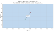
As of the 8 AM best track update, Erin is up to 60 mph. Also, moving due west. Here's the updated NHC Cone from 48 hours ago - it's almost out of the Cone, but not quite. But the NHC clearly expected the WNW turn before now, and it hasn't happened yet.
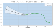
In fact, if we look at the cone issued just last night, it's still moving south of even that forecast.
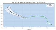
The 3-day error for the Official NHC track is about 120 statute miles (106 nautical miles), and it's mostly in the southern direction and a bit west of forecast. The forecast 3 days ago predicted Erin would be at 18 N at this time, but instead, it's closer to 16 N. In addition to this changing the eventual trajectory, I wonder if this will make it harder for any weakness between the High pressures to even pick Erin up. Definitely a worrying trend.

In fact, if we look at the cone issued just last night, it's still moving south of even that forecast.

The 3-day error for the Official NHC track is about 120 statute miles (106 nautical miles), and it's mostly in the southern direction and a bit west of forecast. The forecast 3 days ago predicted Erin would be at 18 N at this time, but instead, it's closer to 16 N. In addition to this changing the eventual trajectory, I wonder if this will make it harder for any weakness between the High pressures to even pick Erin up. Definitely a worrying trend.

joshoctober16
Member
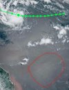
I can see it on Zoom Earth as well.semi offtopic but what is going on to its south? looks like giant waves or something, whatever this is its slowly moving northeast.
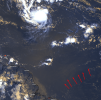
View attachment 46018
If it gets caught between highs, the best thing we can hope for is that it stalls and weakens. But something tells me that that won’t.I was watching a live video podcast channel late last night and there are some new concerning trends. The GFS does move it north but the high builds farther offshore the northeast coast and the storm gets trapped as it moves north. Something to watch.
majorhurricane1703
Member
Still moving west as of 11 am. It will be interesting to see just how much longer that will continue. Another 6 hours of this and the islands will almost certainly be in play.
If it gets caught between highs, the best thing we can hope for is that it stalls and weakens. But something tells me that that won’t.
Cyclonic Paracosm
Member
warneagle
Member
I mean this is exactly what was forecast all along. It was just a matter of waiting for it to get to the better SSTs/less dry air today.
majorhurricane1703
Member
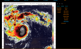
It’s at a higher latitude than yesterday, but not by much with respect to the latitude reported by the NHC. Still thinking it is moving westward despite gaining some latitude.View attachment 46020
thats a jump from last night woow

