• Welcome to TalkWeather!
    We see you lurking around TalkWeather! Take the extra step and join us today to view attachments, see less ads and maybe even join the discussion.
    CLICK TO JOIN TALKWEATHER
  • Current Tropical Systems
    Erin

Hurricane Erin

It’s at a higher latitude than yesterday, but not by much with respect to the latitude reported by the NHC. Still thinking it is moving westward despite gaining some latitude.
Looks like 16.4 N vs 16.3 N. That's only a distance of 6 or 7 miles, and the NHC says it's location placement is accurate to within 25 nautical miles, so I would'nt even say it's gone north any amount, it's still very far within the margin of error.
 
Interesting the 12z hurricane models (and I'll throw in the 12z GFS and Euro too) all initialized 50-100 miles too far north. I understand we keep harping on this southward motion, but just wondering if it'll have any material effect on the outcome. I still expect OTS as the outcome, but I definitely think it's too premature to conclude that definitively.
 
Interesting the 12z hurricane models (and I'll throw in the 12z GFS and Euro too) all initialized 50-100 miles too far north. I understand we keep harping on this southward motion, but just wondering if it'll have any material effect on the outcome. I still expect OTS as the outcome, but I definitely think it's too premature to conclude that definitively.

The thing is the longer a delayed turn continues now makes every new turn more likely to be delayed. I mean just last night the Canadian model had this moving westward initially when it reaches near the eastern Bahamas before starting a northwestward turn and that’s not taking into consideration the farther westward push the system has gained from today. That trough also is forecasted (last I checked) to be farther up by Quebec. The question is will it be strong enough and does the Bermuda high strength continue to trend stronger. The mid latitude atmospheric mechanism especially in the subtropics can be a real challenge for models to pick up on. That’s why a lot of times models don’t pick up on storms that form in the subtropics. I mean if this continues it may not be long before Erin is outside the NHC’s cone from last night
 
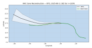
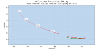
Interestingly, the 18z best track update is just out. It reinforces the WNW motion has started (I don't see it from the satellite, but trusting them I guess), puts it at 16.6 N.

This is outside the cone from 3 days ago by about 25 miles to the south.

1755197393694.png


It is still inside the NHC Cone from 2 days ago, but hangs on the southern side of it. Same with the NHC Cone from 24 hours ago.


Here's the official track moving into the future (it fades out when accuracy drops to untrustworthy levels, based on its performance thus far). It definitely shows a WNW/NW motion pretty steadily from here on out, so let's see if that continues.

1755197951543.png
 
Interestingly, the 18z best track update is just out. It reinforces the WNW motion has started (I don't see it from the satellite, but trusting them I guess), puts it at 16.6 N.

This is outside the cone from 3 days ago by about 25 miles to the south.

View attachment 46022


It is still inside the NHC Cone from 2 days ago, but hangs on the southern side of it. Same with the NHC Cone from 24 hours ago.


Here's the official track moving into the future (it fades out when accuracy drops to untrustworthy levels, based on its performance thus far). It definitely shows a WNW/NW motion pretty steadily from here on out, so let's see if that continues.

View attachment 46025

Remains to be seen how much latitude it can consistently gain. Interested to see how this plays out.
 
Interestingly, the 18z best track update is just out. It reinforces the WNW motion has started (I don't see it from the satellite, but trusting them I guess), puts it at 16.6 N.

This is outside the cone from 3 days ago by about 25 miles to the south.

View attachment 46022


It is still inside the NHC Cone from 2 days ago, but hangs on the southern side of it. Same with the NHC Cone from 24 hours ago.


Here's the official track moving into the future (it fades out when accuracy drops to untrustworthy levels, based on its performance thus far). It definitely shows a WNW/NW motion pretty steadily from here on out, so let's see if that continues.

View attachment 46025
Something interesting to note with Erin I looked up on chat gpt with regards to wobbles:
Based on what we’ve seen so far, there’s reason to expect more southward or west-southwest wobbles than northward ones. Here’s why that’s plausible for Erin:

  1. Current position relative to steering flows:
    • At ~16.6°N, Erin is on the southern edge of the subtropical ridge. The ridge is stronger to the north, which tends to push storms westward rather than allowing a northward jog.
  2. Delayed WNW turn:
    • Erin’s turn toward WNW was about 24 hours late. That suggests the steering currents aren’t favoring northward motion strongly yet. The storm is “struggling” to get under the influence of the mid-latitude trough, making south or west wobbles more likely in the short term.
  3. Small, developing cyclone:
    • Smaller systems are more susceptible to mesoscale effects and subtle wind asymmetries. This often produces asymmetric motion wobbles — in this case, slightly south of the mean track more often than north.
 
Interestingly, the 18z best track update is just out. It reinforces the WNW motion has started (I don't see it from the satellite, but trusting them I guess), puts it at 16.6 N.

This is outside the cone from 3 days ago by about 25 miles to the south.

View attachment 46022


It is still inside the NHC Cone from 2 days ago, but hangs on the southern side of it. Same with the NHC Cone from 24 hours ago.


Here's the official track moving into the future (it fades out when accuracy drops to untrustworthy levels, based on its performance thus far). It definitely shows a WNW/NW motion pretty steadily from here on out, so let's see if that continues.

View attachment 46025
National Hurricane Center didn’t agree. Still has it moving west.
 
The 5 PM advisory is out, and the slight drift northward is continuing, along with the westward push.

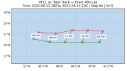
Here's the 48-hour errors on the OFCL NHC track. The track looks like it's getter more accurate over the past 24 hours. We'll see if that continues.


1755206428609.png


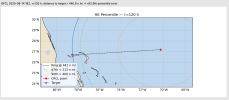
I also wanted to see "How crazy would the path have to be to hit X?", in this case, Grand Bahama. Based on 2020-2024 errors, this landfall is in the 92.9th percentile of track errors, so definitely not impossible, but pretty improbable.


1755206308598.png
 
View attachment 46033
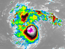
little thing to keep in mind is , that storms that tend to rapidly intensify (in the Atlantic) tend to have a strange blob of storm beside it , mostly in the north to east side.

its starting to have one of these blobs however its more on the NNW side.
It’s also just a blob of a storm with notable spiraling rotation in it’s tops now. It could be preparing to undergo some form of R.I
 
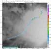
A few 64kt barbs already found early on in the mission.

IMG_4982.png
 
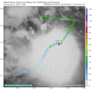
Some indications that the low level center may be trying to reform further to the south underneath the mid-level center. That would be another shift south. Hmmm.
It’s actually further north than expected:
IMG_5018.png
 
Yeah further north than expected doesn’t make sense to me in this context not when the tendency has been south.
Well that’s what recon plotted on the chart above. As @wx_guy said, it could reform further south and align with the mid-level center.
 
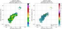
Here is this, the first of 2025:

IMG_5022.jpeg
IMG_5023.jpeg
 
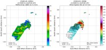
Super interesting! The mid-level center (5 km) is much more robust than the low-level (1 km) one. The low-level center is still a weaker tropical storm, which I didn't expect. Maybe it's actively trying to reorganize itself under the mid-level center, guess we'll see.
 
A third one that I forgot;
 
Back
Top