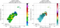
There was a third image I missed, but it won’t let me select it to post it.Super interesting! The mid-level center (5 km) is much more robust than the low-level (1 km) one. The low-level center is still a weaker tropical storm, which I didn't expect. Maybe it's actively trying to reorganize itself under the mid-level center, guess we'll see.
Navigation
Install the app
How to install the app on iOS
Follow along with the video below to see how to install our site as a web app on your home screen.
Note: This feature may not be available in some browsers.
More options
-
Welcome to TalkWeather! We see you lurking around TalkWeather! Take the extra step and join us today to view attachments, see less ads and maybe even join the discussion. CLICK TO JOIN TALKWEATHER
You are using an out of date browser. It may not display this or other websites correctly.
You should upgrade or use an alternative browser.
You should upgrade or use an alternative browser.
Hurricane Erin
- Thread starter wx_guy
- Start date
They are decending in for another pass
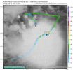
It’s actually further north than expected:
View attachment 46038

- Thread starter
- #84
wx_guy
Member
- Messages
- 1,204
- Reaction score
- 4,326
- Location
- United States
- HAM Callsign
- KO4ZGH
- Special Affiliations
- SKYWARN® Volunteer
- ARRL Member
8 PM special advisory issued upping Erin to 70 mph.
- Thread starter
- #85
wx_guy
Member
- Messages
- 1,204
- Reaction score
- 4,326
- Location
- United States
- HAM Callsign
- KO4ZGH
- Special Affiliations
- SKYWARN® Volunteer
- ARRL Member
Also interesting verbiage in the special advisory discussion:
At 800 PM AST (0000 UTC), the center of Tropical Storm Erin was
located near latitude 16.9 North, longitude 51.9 West. Erin is
moving toward the west near 17 mph (28 km/h). A turn toward the
west-northwest is expected tonight, with this motion expected to
continue into the weekend. On the forecast track, the center of
Erin is likely to move near or just north of the northern Leeward
Islands over the weekend.
NOAA aircraft data indicates that maximum sustained winds have
increased to near 70 mph (110 km/h) with higher gusts. Additional
strengthening is forecast during the next few days and Erin is
expected to soon become a hurricane and could become a major
hurricane by the end of this weekend.
First mention I've seen that landfall in the islands is possible.
majorhurricane1703
Member
Super interesting! The mid-level center (5 km) is much more robust than the low-level (1 km) one. The low-level center is still a weaker tropical storm, which I didn't expect. Maybe it's actively trying to reorganize itself under the mid-level center, guess we'll see.
That’s plausible and it would make sense as there is more dry air to the north than the south so the mid level center could win out. Boy that could be a major game changer if that occurred.
Game changer how?That’s plausible and it would make sense as there is more dry air to the north than the south so the mid level center could win out. Boy that could be a major game changer if that occurred.
- Thread starter
- #88
wx_guy
Member
- Messages
- 1,204
- Reaction score
- 4,326
- Location
- United States
- HAM Callsign
- KO4ZGH
- Special Affiliations
- SKYWARN® Volunteer
- ARRL Member
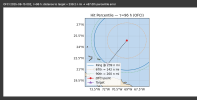
The Turks and Caicos are another destination I've been looking at if Erin could hit. At 4 days out, the Cone goes out 142 nautical miles. In order to make landfall in the T&C islands, it'd need to deviate from its forecast point by 239 nautical miles, putting it in the 87th percentile error from 2020-2024 track errors. Hard, but not impossible.

majorhurricane1703
Member
It the MLC tugs the low level center more south (especially before the WNW movement) that could alter the track even more south and west. Obviously timing with the trough still also plays a critical role here, but the MLC winning out isn’t necessarily good news that’s for sure.Game changer how?
Intensity-wise for Erin it is good news, but bad for us.It the MLC tugs the low level center more south (especially before the WNW movement) that could alter the track even more south and west. Obviously timing with the trough still also plays a critical role here, but the MLC winning out isn’t necessarily good news that’s for sure.
I’m still uncertain in the future path of this storm. It’s just more difficult than usual to pinpoint where it will recurve and what not.
- Thread starter
- #91
wx_guy
Member
- Messages
- 1,204
- Reaction score
- 4,326
- Location
- United States
- HAM Callsign
- KO4ZGH
- Special Affiliations
- SKYWARN® Volunteer
- ARRL Member
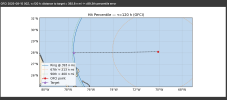
I picked a point a bit east of the Bahamas, the thinking being that if Erin can get to 77 or 78 longitude, it has much better chances of making a landfall attempt in the Carolinas. It turns out it's pretty closely at the 90th percentile error for 5 days out, using 2020-2024 data, so 10% of the time, larger errors than this at 5 days out have occurred. Even though it's not a pure translation, I'd say that's a good guess at the current chances of a U.S. landfall -- about 10%. Enough to be Alert, but not enough to Worry.

majorhurricane1703
Member
Intensity-wise for Erin it is good news, but bad for us.
I’m still uncertain in the future path of this storm. It’s just more difficult than usual to pinpoint where it will recurve and what not.
Intensity-wise for Erin it is good news, but bad for us.
I’m still uncertain in the future path of this storm. It’s just more difficult than usual to pinpoint where it will recurve and what not.
I agree. I really
The Turks and Caicos are another destination I've been looking at if Erin could hit. At 4 days out, the Cone goes out 142 nautical miles. In order to make landfall in the T&C islands, it'd need to deviate from its forecast point by 239 nautical miles, putting it in the 87th percentile error from 2020-2024 track errors. Hard, but not impossible.
View attachment 46043
I don’t know that I can take the models all that seriously yet. This storm seems to be a case of models failing to initialize properly and the NHC who I consider the gold standard for modeling isn’t exactly doing great with this storm either even though it has improved since yesterday. That warm water in the mid latitudes makes me wonder if a stronger high than models think will set in. I think the eastern Bahamas are very much in play here at the very least. This recon mission with the center location is going to be massively critical as timing with the trough could easily be missed if this doesn’t move west northwest soon.
majorhurricane1703
Member
In fact (unless my eyes are deceiving me) after a jog west northwest it seems to be moving back on a more due west path. I’m interested to see what they have as the motion at 11 pm.I agree. I really
I don’t know that I can take the models all that seriously yet. This storm seems to be a case of models failing to initialize properly and the NHC who I consider the gold standard for modeling isn’t exactly doing great with this storm either even though it has improved since yesterday. That warm water in the mid latitudes makes me wonder if a stronger high than models think will set in. I think the eastern Bahamas are very much in play here at the very least. This recon mission with the center location is going to be massively critical as timing with the trough could easily be missed if this doesn’t move west northwest soon.
- Thread starter
- #94
wx_guy
Member
- Messages
- 1,204
- Reaction score
- 4,326
- Location
- United States
- HAM Callsign
- KO4ZGH
- Special Affiliations
- SKYWARN® Volunteer
- ARRL Member
*steps on soap box for a moment*
It may well happen that Erin "behaves" and goes OTS as the models are showing. But this is an excellent time to opine on the models themselves. The ensembles are NOT the "universe of possibilities" as some like to think of them, that's just a simplifying assumption. The deterministic models and the AI models both struggle with "grey swan" events that are rare or "black swan" events that are unprecedented. A good example is a landfalling major hurricane into Georgia. The models can even agree with each other and have seemingly high confidence but still be wrong. There's around 650 miles between Bermuda and Cape Hatteras, which sounds like a lot, but about 5% of the time, the 5-day NHC track error is close to that, if you use 2020-2024 data. The truth is the models are largely trained on a lot of the same data so exhibit a lot of the same biases and tendencies. Anytime we see a bifurcation in the models (for example, the hurricane models now in a "west" camp vs almost everything else in an "east" camp), that's a sign that the accuracy of the models is suspect at that point. In chaotic systems like the atmosphere, bifurcation points like that are common and can drastically change the results. In distributions where the tail is rare, it is difficult for most statistical or numeric models to predict with any degree of accuracy, and this is no exception. Too many on X and online and even meteorologists often put too much faith and trust in the models without realizing the very real occasional big error. I mean, even just *3 days out*, 10% of the errors are about 200 or more miles off. Yes, the models are great. Yes, we've come a long way. But we need to acknowledge they ARE wrong, almost always. They're just a useful approximation.
It may well happen that Erin "behaves" and goes OTS as the models are showing. But this is an excellent time to opine on the models themselves. The ensembles are NOT the "universe of possibilities" as some like to think of them, that's just a simplifying assumption. The deterministic models and the AI models both struggle with "grey swan" events that are rare or "black swan" events that are unprecedented. A good example is a landfalling major hurricane into Georgia. The models can even agree with each other and have seemingly high confidence but still be wrong. There's around 650 miles between Bermuda and Cape Hatteras, which sounds like a lot, but about 5% of the time, the 5-day NHC track error is close to that, if you use 2020-2024 data. The truth is the models are largely trained on a lot of the same data so exhibit a lot of the same biases and tendencies. Anytime we see a bifurcation in the models (for example, the hurricane models now in a "west" camp vs almost everything else in an "east" camp), that's a sign that the accuracy of the models is suspect at that point. In chaotic systems like the atmosphere, bifurcation points like that are common and can drastically change the results. In distributions where the tail is rare, it is difficult for most statistical or numeric models to predict with any degree of accuracy, and this is no exception. Too many on X and online and even meteorologists often put too much faith and trust in the models without realizing the very real occasional big error. I mean, even just *3 days out*, 10% of the errors are about 200 or more miles off. Yes, the models are great. Yes, we've come a long way. But we need to acknowledge they ARE wrong, almost always. They're just a useful approximation.
Tropical Storm Erin Discussion Number 15
NWS National Hurricane Center Miami FL AL052025
1100 PM AST Thu Aug 14 2025
Erin has intensified tonight. The first NOAA-P3 reconnaissance
mission into the storm found that the center was a little more
embedded in the deep convection than earlier with a compact wind
field particularly strong on the eastern flank. Tail Doppler Radar
data from the aircraft indicated the center is starting to become
better aligned, though some residual southward tilt with height
still exists, which can also be seen on a 2339 UTC GMI microwave
pass. In the most recent leg, peak 700-mb flight level winds from
the NOAA aircraft were 69 kt in the northeast quadrant. This
value reduces to surface wind near 60 kt, just shy of
hurricane intensity.
Erin is now starting to move west-northwestward at 285/15 kt. An
extensive mid-level ridge stretched from off the eastern United
States coast all the way to the eastern Atlantic remains in place
helping to steer the storm generally west-northwestward for at least
the next 2 to 3 days with it gradually slowing down. During this
time-span, a mid-latitude trough moving into the northwestern
Atlantic is expected to dig equatorward to the northeast of Bermuda,
with another reinforcing shortwave moving into Atlantic Canada
towards the end of the forecast period. These features should create
a weakness in the subtropical ridge that Erin is expected to turn
northwestward and north-northwestward into. The latest track
guidance was quite similar to the prior cycle, just a little faster
than before towards the end of the forecast period, and only small
adjustments were made to the NHC forecast track. This track roughly
splits the latest forecast from the Google Deep Mind (GDMI) and HCCA
consensus aid. Still, there is a healthy amount of spread in the
guidance and uncertainty remains about what impacts Erin may bring
to portions of the Bahamas, the east coast of the United States, and
Bermuda in the long range.
With Erin's core structure improving this evening, the storm appears
poised to intensify more quickly in the short term. Rapid
intensification probabilities have increased in SHIPS guidance, with
now a 38-40 percent chance of a 30 kt increase in the next 24 h. The
environment continues to become more thermodynamically favorable,
with Erin crossing into 28C and warmer sea-surface temperatures, and
mid-level moisture increasing over the forecast time period. Thus,
the NHC intensity forecast will show more intensification over the
next 48-60 hours, and Erin is now forecast to become a major
hurricane earlier and peak at 115 kt, category 4 intensity. After
that time, there remains evidence in both SHIPS guidance and model
fields that northwesterly vertical wind shear could increase over
the system. In addition, there is a good chance Erin may begin to
undergo inner-core structural changes, like eyewall replacement
cycles, that could broaden its wind field but also cause its
intensity to plateau. Thus, the NHC intensity forecast now shows
some gradual weakening after a peak intensity in 72 h, though the
models show the wind radii expanding quite dramatically in the day
3-5 period. The latest NHC intensity forecast is a little on the
high side of the guidance, especially in the short-term, but ends up
near the consensus aids HCCA and IVCN towards the end of the
forecast period.
KEY MESSAGES:
1. Heavy rainfall across the northernmost Leeward Islands, the U.S.
and British Virgin Islands, as well as southern and eastern Puerto
Rico, may lead to isolated flash and urban flooding, along with
landslides or mudslides this weekend into early next week.
2. Tropical storm conditions are possible for portions of the
northern Leeward Islands, where Tropical Storm Watches are in
effect, beginning on Saturday as the core of Erin passes north of
those islands. Tropical storm conditions could also occur in
portions of the Virgin Islands and Puerto Rico later in the weekend,
and additional watches may be required tonight or on Friday.
3. While there is still uncertainty in what impacts might occur in
portions of the Bahamas, the east coast of the United States, and
Bermuda next week, the risk of dangerous surf and rip currents
across the western Atlantic basin next week continues to increase.
FORECAST POSITIONS AND MAX WINDS
INIT 15/0300Z 17.1N 52.7W 60 KT 70 MPH
12H 15/1200Z 17.8N 55.2W 70 KT 80 MPH
24H 16/0000Z 18.6N 58.3W 80 KT 90 MPH
36H 16/1200Z 19.4N 61.0W 90 KT 105 MPH
48H 17/0000Z 20.3N 63.3W 100 KT 115 MPH
60H 17/1200Z 21.3N 65.4W 110 KT 125 MPH
72H 18/0000Z 22.4N 67.0W 115 KT 130 MPH
96H 19/0000Z 25.0N 69.4W 110 KT 125 MPH
120H 20/0000Z 28.0N 70.4W 105 KT 120 MPH
$$
Forecaster Papin
- Thread starter
- #99
wx_guy
Member
- Messages
- 1,204
- Reaction score
- 4,326
- Location
- United States
- HAM Callsign
- KO4ZGH
- Special Affiliations
- SKYWARN® Volunteer
- ARRL Member
Erin's path is looking increasingly certain to head out to sea, and the forecasts are slowly starting to congeal.
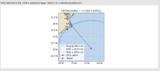
However, a U.S. landfall on the Outer Banks is still possible. It's pretty unlikely, but only in the 89th percentile of errors the past 5 years at 5 days out. So statistically, it's still possible. Granted, I don't want that to happen, but we can't give the "all clear" yet.
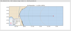
In contrast, Jacksonville, FL is almost statistically impossible (and likely probably is), with the storm needing to deviate over 500 miles off course.
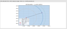
Finally, Bermuda is at the 84th percentile, only needing to deviate 340 nautical miles. So at this time, the most likely 5-6 day destination looks to be Bermuda, but even then OTS is greatly favored.
In essentially all cases, in order for Erin to NOT be a pure OTS hurricane, the track error needs to be 1.5 - 2.5 x the normal errors, and I just don't see that happening.
However, a U.S. landfall on the Outer Banks is still possible. It's pretty unlikely, but only in the 89th percentile of errors the past 5 years at 5 days out. So statistically, it's still possible. Granted, I don't want that to happen, but we can't give the "all clear" yet.

In contrast, Jacksonville, FL is almost statistically impossible (and likely probably is), with the storm needing to deviate over 500 miles off course.

Finally, Bermuda is at the 84th percentile, only needing to deviate 340 nautical miles. So at this time, the most likely 5-6 day destination looks to be Bermuda, but even then OTS is greatly favored.

In essentially all cases, in order for Erin to NOT be a pure OTS hurricane, the track error needs to be 1.5 - 2.5 x the normal errors, and I just don't see that happening.
tornado examiner
Member
Rapid intensification will be fun to watch. As always.

