Navigation
Install the app
How to install the app on iOS
Follow along with the video below to see how to install our site as a web app on your home screen.
Note: This feature may not be available in some browsers.
More options
-
Welcome to TalkWeather! We see you lurking around TalkWeather! Take the extra step and join us today to view attachments, see less ads and maybe even join the discussion. CLICK TO JOIN TALKWEATHER
You are using an out of date browser. It may not display this or other websites correctly.
You should upgrade or use an alternative browser.
You should upgrade or use an alternative browser.
Hurricane Erin
- Thread starter wx_guy
- Start date
tornado examiner
Member
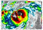
What does that blob mean for the center of the hurricane?2 things to say.
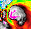
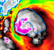
1:here we go with the pareidolia hurricanes having these creepy human faces.
View attachment 46052
View attachment 46053
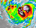
2: the blob is now to the south west side of the hurricane
View attachment 46051
New NHC peak continues to be raised, from 115 kts at 5 AM this morning to 120 kts at 11 AM this morning. The new 5 PM advisory raised the peak yet again. This time it is now 125 kts.2 things to say.
1:here we go with the pareidolia hurricanes having these creepy human faces.
View attachment 46052
View attachment 46053
2: the blob is now to the south west side of the hurricane
View attachment 46051
ICON wants this to have a pressure between 920-905 mb, which I don’t trust yet due to the flop it recently had back in July with 93L.
ICON is also calling for a decently strong Category 5 along with the pressure.
It’s kind of like an insolator, protecting it from shear, dust, etc.What does that blob mean for the center of the hurricane?
Milton back in October had a blob to its NE on several occasions.
tornado examiner
Member
What are the chances Erin goes ballistic soaring into cat 5 territory but doesn’t get the official upgrade due to a lack of recon data?New NHC peak continues to be raised, from 115 kts at 5 AM this morning to 120 kts at 11 AM this morning. The new 5 PM advisory raised the peak yet again. This time it is now 125 kts.
ICON wants this to have a pressure between 920-905 mb, which I don’t trust yet due to the flop it recently had back in July with 93L.
ICON is also calling for a decently strong Category 5 along with the pressure.
I recall that happening with another storm before.
Are you talking about Eta? Eta had super cold cloud tops (a full thick pink ring) on satellite but that was because the tropopause was higher in the W.Caribbean at the time of Eta. The very cold cloud tops made it look like Eta was a strong Category 5 but recon measures winds ~135 kts, and so they put the peak intensity at 130 kts.What are the chances Erin goes ballistic soaring into cat 5 territory but doesn’t get the official upgrade due to a lack of recon data?
I recall that happening with another storm before.
It’s a possibility, a non-zero chance. However the odds of the NHC not using the HH data to upgrade Erin to Category 5 status is low (if Erin gets close to Category 5 status at all)
For the EPAC, it’s common to see storms that look like they were borderline Category 5 to be underestimated it seems.What are the chances Erin goes ballistic soaring into cat 5 territory but doesn’t get the official upgrade due to a lack of recon data?
I recall that happening with another storm before.
TornadoFan
Member
- Thread starter
- #111
wx_guy
Member
- Messages
- 1,202
- Reaction score
- 4,315
- Location
- United States
- HAM Callsign
- KO4ZGH
- Special Affiliations
- SKYWARN® Volunteer
- ARRL Member
The exciting part of this story (the RI) is now ongoing. Let's dig in.
First, the models -- what do the 5-day errors show?
The HAFS-A and HAFS-B and GFS. For reference, the 67th percentile of 5-day error the past 5 years has been 213 nautical miles.
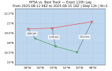
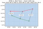
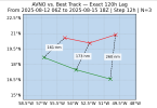
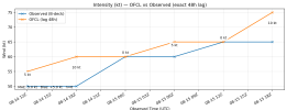
What about the intensity, now that it's starting to intensify? This will be monitored closely over the next 72 hours. For now, I'll focus on the 24-hour error from the OFCL forecast.
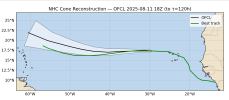
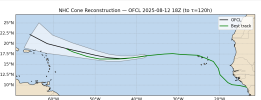
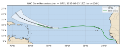
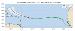
Next, let's look at how the track has fared vs. the NHC Cone so far. Here are cones from 18z on the 11th, 12th, 13th, and 14th. Any deviations outside of the Cone have essentially corrected themselves at this point, and the NHC forecasts are very accurate it looks like.
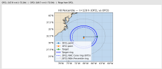
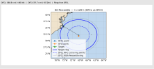
Okay, what about future land interactions? For Bermuda, the island lies just outside the official NHC Cone and is at about the 72nd percentile of historical errors. And Cape Hatteras is also possible, but at the 87th percentile, it's pretty unlikely (it'd have to deviate by about 1.5X the NHC Cone's radius.)
So all in all it looks likely that Erin will be an out-to-sea storm, but a really interesting large and powerful storm! Interested to see how it goes down.
First, the models -- what do the 5-day errors show?
The HAFS-A and HAFS-B and GFS. For reference, the 67th percentile of 5-day error the past 5 years has been 213 nautical miles.


What about the intensity, now that it's starting to intensify? This will be monitored closely over the next 72 hours. For now, I'll focus on the 24-hour error from the OFCL forecast.

Next, let's look at how the track has fared vs. the NHC Cone so far. Here are cones from 18z on the 11th, 12th, 13th, and 14th. Any deviations outside of the Cone have essentially corrected themselves at this point, and the NHC forecasts are very accurate it looks like.


Okay, what about future land interactions? For Bermuda, the island lies just outside the official NHC Cone and is at about the 72nd percentile of historical errors. And Cape Hatteras is also possible, but at the 87th percentile, it's pretty unlikely (it'd have to deviate by about 1.5X the NHC Cone's radius.)


So all in all it looks likely that Erin will be an out-to-sea storm, but a really interesting large and powerful storm! Interested to see how it goes down.
That’s interesting! Glad to all but remove the possibility of a landfall on the east coast.The exciting part of this story (the RI) is now ongoing. Let's dig in.
First, the models -- what do the 5-day errors show?
The HAFS-A and HAFS-B and GFS. For reference, the average 5-day error the past 5 years has been 213 nautical miles.
View attachment 46055
View attachment 46056
View attachment 46057
What about the intensity, now that it's starting to intensify? This will be monitored closely over the next 72 hours. For now, I'll focus on the 24-hour error from the OFCL forecast.
View attachment 46058
Next, let's look at how the track has fared vs. the NHC Cone so far. Here are cones from 18z on the 11th, 12th, 13th, and 14th. Any deviations outside of the Cone have essentially corrected themselves at this point, and the NHC forecasts are very accurate it looks like.
View attachment 46060
View attachment 46061
View attachment 46062
View attachment 46063
Okay, what about future land interactions? For Bermuda, the island lies just outside the official NHC Cone and is at about the 72nd percentile of historical errors. And Cape Hatteras is also possible, but at the 87th percentile, it's pretty unlikely (it'd have to deviate by about 1.5X the NHC Cone's radius.)
View attachment 46066
View attachment 46067
So all in all it looks likely that Erin will be an out-to-sea storm, but a really interesting large and powerful storm! Interested to see how it goes down.
Though models are starting to trend a new signal behind Erin in the MDR.
Several different recon missions hand measured winds between 75-81 kts in Erin now. I got 78 kts for an average. So winds seem to be roughly at 75 kts raw, but I could see the NHC upping the winds at the next intermediate advisory.
I think those winds measured could definitely support an intensity of 70 kts now.
I think those winds measured could definitely support an intensity of 70 kts now.
tornado examiner
Member
Rapid intensification has officially begun.
It’s off to the race’s now.
It’s off to the race’s now.
The 8 PM intermediate advisory upgraded Erin to 75 kts (85 mph) with a pressure of 982 mb.
This thing wasn’t supposed to get to 85 mph until early tomorrow morning according to the 5 PM advisory. Erin is intensifying ahead of schedule.
This thing wasn’t supposed to get to 85 mph until early tomorrow morning according to the 5 PM advisory. Erin is intensifying ahead of schedule.
tornado examiner
Member
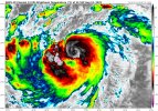
Also I was predicting a pinhole eye and it looks like that is indeed happening.
I’m guessing a pinhole eye is a bad sign. A sign that the storm could intensify really fast.Also I was predicting a pinhole eye and it looks like that is indeed happening.
- Thread starter
- #118
wx_guy
Member
- Messages
- 1,202
- Reaction score
- 4,315
- Location
- United States
- HAM Callsign
- KO4ZGH
- Special Affiliations
- SKYWARN® Volunteer
- ARRL Member
Yes, many of the really truly intense Cat 5's have had pinhole eyes, like Wilma's 2 mile-wide eye.I’m guessing a pinhole eye is a bad sign. A sign that the storm could intensify really fast.
I mean Erin is intensifying ahead of schedule, so that is ominous too.Yes, many of the really truly intense Cat 5's have had pinhole eyes, like Wilma's 2 mile-wide eye.
If ICON is right, Erin would become one of the northernmost storms in Atlantic history to have a pressure in 920s or below.Yes, many of the really truly intense Cat 5's have had pinhole eyes, like Wilma's 2 mile-wide eye.

