
I expect they are though - she's looked horrible all day. In order to restrengthen or even hold its own, first the structure has to be stacked, then dry air expelled, then pressure drops, then winds respond. Shear tends to mess up the vertical alignment of the CDO, making it less symmetrical, slowing winds. I think the shear has relaxed some, allowing the structure to look better. It's got a long way to go before the results of that relaxing shear are seen in the winds though, and may not - there's drier air on the Yucatan she may ingest that will offset the better structure. Lots of variables in play.And somehow NHC winds are down to 110mph from 115.
Navigation
Install the app
How to install the app on iOS
Follow along with the video below to see how to install our site as a web app on your home screen.
Note: This feature may not be available in some browsers.
More options
-
Welcome to TalkWeather! We see you lurking around TalkWeather! Take the extra step and join us today to view attachments, see less ads and maybe even join the discussion. CLICK TO JOIN TALKWEATHER
You are using an out of date browser. It may not display this or other websites correctly.
You should upgrade or use an alternative browser.
You should upgrade or use an alternative browser.
Hurricane Hurricane Beryl
- Thread starter Casuarina Head
- Start date
She's got that "half a hurricane" look to her on water vapor - lots of drier air on the SE side.

jiharris0220
Member
Live stream of the damage by Brandon for those interested.
jiharris0220
Member
Tossed and mutilated vehicle, these winds were definitely extreme,

TornadoFan
Member
Pretty big convection popping up on GOES as the sun goes down. (First post!)
This would suggest Beryl is a category 3 again.
TornadoFan
Member
Honestly, I don't have any words to describe this storm anymore.
Hurricane Beryl Tropical Cyclone Update
NWS National Hurricane Center Miami FL AL022024
930 PM EDT Thu Jul 4 2024
...BERYL STRENGTHENS BACK TO A CATEGORY 3 HURRICANE AS IT NEARS THE
YUCATAN PENINSULA...
Data from the Air Force reconnaissance aircraft indicate that Beryl has strengthened to a category 3 hurricane with maximum winds of 115 mph (185 km/h). The aircraft data also indicated that the minimum pressure has fallen to 962mb
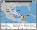
I believe we can pretty much say that Texas is gonna be the target zone. Anywhere from South Texas to the Upper Texas Coast. I don't believe this is gonna be a Mexico landfall anymore. According to NHC, Beryl will only be on land for 18 hours as it crosses the Yucatan assuming it doesn't cross further north. A more northern hit on the Yucatan will limit how long it stays over land. My bet is Beryl's center stays mainly intact and that's a pretty good bet given how Beryl has been acting. It should reintensify over the Gulf once it comes off the Yucatan. Forward speed will slow down once in the Gulf so the only hinderance it may have with rapidly intensifying again would be if it sits and spins for too long over the same area. However, Beryl's surprises may not be done yet. She'll find a way to rapidly intensify again.
Attachments
wx_guy
Member
- Messages
- 1,237
- Reaction score
- 4,443
- Location
- United States
- HAM Callsign
- KO4ZGH
- Special Affiliations
- SKYWARN® Volunteer
- ARRL Member
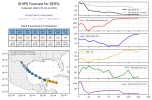
Here's my custom graphic (of course NOT OFFICIAL) for the latest for Beryl. It plots the latest Official forecast track (black), along with the HAFS-a (orange), HAFS-B (purple), GEFS ensemble mean [AEMN] (dark blue), Canadian ensemble mean [CEMN] (dark red), UK Met [EGRR] (light green), Navy NAVGEM model [NVGM] (cyan), and the GFS operational model [AVNO] (golden). Of particular interest are the circles on the map --> unlike the NHC's cone (which is essentially static and based on the past 5 years of error data), these circles are dynamic to this storm and these models. The gray circles represent a 95% confidence interval prediction for the center of the storm, given these models as input. The pink outer circles are the TS-force winds "avoidance zones" -- based on forecast wind radii and the given confidence intervals, these are the reasonably furthest areas that may experience TS-force winds.
The big thing to note here is at 3-4 day range, the uncertainty grows HUGELY in size. This type of uncertainty can't be directly dynamically expressed using the current cone from the NHC (but comparing it with this shows the uncertainty pretty well, too). It definitely is looking more concerning for a Texas landfall...and Louisiana can't be 100% confident yet. And a Mexico final landfall is still very possible, too.

The big thing to note here is at 3-4 day range, the uncertainty grows HUGELY in size. This type of uncertainty can't be directly dynamically expressed using the current cone from the NHC (but comparing it with this shows the uncertainty pretty well, too). It definitely is looking more concerning for a Texas landfall...and Louisiana can't be 100% confident yet. And a Mexico final landfall is still very possible, too.
jiharris0220
Member
Here’s a photo from another recent video of Carriacou, looks like something out of an apocalypse movie set.

Here’s the video link.
Here’s the video link.
Really glad to see she ran out of time before reintensifying too much. Still, Cozumel and Cancun likely took a pretty decent hit. Thankfully it looks like she's burying herself pretty deeply into the Yucatan - that should wind her down a good bit. It will be interesting to see what happens when she reemerges. The water in the SW gulf, while not as hot as the Caribbean, will likely still support her well, but I think the chances of her ramping up to something ridiculous are less there. Certainly a storm that has defied expectation, so we'll see.
wx_guy
Member
- Messages
- 1,237
- Reaction score
- 4,443
- Location
- United States
- HAM Callsign
- KO4ZGH
- Special Affiliations
- SKYWARN® Volunteer
- ARRL Member
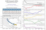
Here's this morning's Mini-Ensemble. If I were a betting person, South Texas is the hot zone, with the area from Brownsville to Corpus Christi the biggest area to watch out for a landfall. The morning model runs (this uses the HAFS-A, HAFS-B, GEFS mean, Canadian ensemble mean, UK Met, Navy model, GFS operational, and the official track) are pretty tightly clustered overall, but this will be tracked closely over the next 24 hours. How the storm looks when it reaches the Gulf is paramount.
As a reminder, the gray circles are a 95% confidence interval, given the spread of the models plotted. The pink shaded area is the furthest possible extent of TS-force winds, given the confidence intervals and the official track forecasted.

As a reminder, the gray circles are a 95% confidence interval, given the spread of the models plotted. The pink shaded area is the furthest possible extent of TS-force winds, given the confidence intervals and the official track forecasted.
Also one has to wonder if Beryl tries to relocate it's center further north
slenker
Member
The spaghetti models for Beryl have continued to trend towards a further north landfall, with a lot of them now showing a direct impact in the Corpus Christi area. I have a strong feeling the system will rapidly intensify before striking the US as well, given its history. I know that doesn't necessarily mean anything in it and of itself, but Beryl has surprised us quite a bit, and I don't think she's fully done with that. People in South Texas should prepare for at least a minimal hurricane.
CoC will emerge into the Gulf, north of Merida some time this afternoon. Still on the northern side of guidance.