- Thread starter
- #41
AJS
Member
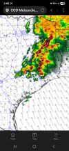
Got a couple of cells that could go right through my area according to this run..View attachment 41007
A semi discrete mode with a few discrete cells in TX/LA. The 16z run seems MDT worthy to me.
Follow along with the video below to see how to install our site as a web app on your home screen.
Note: This feature may not be available in some browsers.
Got a couple of cells that could go right through my area according to this run..View attachment 41007
A semi discrete mode with a few discrete cells in TX/LA. The 16z run seems MDT worthy to me.
Yeah, that HRRR run is a bit concerning though.Yea, I'm hoping they go with a MDT, just to be safe. Not going to be a "historic outbreak" of course, but could be a December 28-type situation, where we saw that violent (received an EF3-rating, though) tornado that went south of Port Arthur.
Interesting, you don't see the "SOURCE" column being that specific very oftenAt 12:14 PM, Milam County Sheriff Office reported a tornado on FM 1600 (reading the warning text of the tornado warned storm)
I can't really recall them doing that to increase a risk. They did issue an updated outlook on 4/27/2014, day of the Vilonia EF-4, that downgraded the risk from a High to a moderate across Arkansas about an hour after they issued their evening outlook.Has the SPC ever done an upgrade before the next scheduled update
Whoever reported it had to be very close, I don't know how you'd see anything in that mess of rain.Interesting, you don't see the "SOURCE" column being that specific very often

Also, in case it's not clear, I'm not calling for an #eventcancel. That outflow is still pretty far from the Houston metro and I wouldn't go as far as saying that Bryan-College Station is out of the woods yet for a tornado threat either.I spy crashing outflow from west of Lexington to north of Wimberley. This could undercut storms that try to form out in front of it.
Where do you guys think the best chance for discrete activity is?Also, in case it's not clear, I'm not calling for an #eventcancel. That outflow is still pretty far from the Houston metro and I wouldn't go as far as saying that Bryan-College Station is out of the woods yet for a tornado threat either.
Probably west of the Houston metro. And a very conditional risk in southern Louisiana.Where do you guys think the best chance for discrete activity is?
HRRR has a long track supercell a long the Lousianna Mississippi southern border. Not sure if I'm buying but looks to be along the warm front.Where do you guys think the best chance for discrete activity is?
Also. I really don't like the look of the OWS stuff in Southeast Texas on future radar. That's going to cause some major issues if it verifies, maybe it gets too clutter and the storms choke each other off, atleast I hope. (Low level lapse rates are pretty low currently that maybe a hiccup as well)