
ashtonlemleywx
Member
Got my GoPro and drone batteries charged. I'll be chasing MS Delta this afternoon.
Follow along with the video below to see how to install our site as a web app on your home screen.
Note: This feature may not be available in some browsers.
Good luck,stay safe! Could be a strong one or twoGot my GoPro and drone batteries charged. I'll be chasing MS Delta this afternoon.
Looks like we were on it JPWX....Upgrade that is.Day 1 1300z Outlook.

3 cape is around 250 good grief that's a spectacle, probably be some amazing low level clouds.
Near Tupleo, MS. at 00Z. Pretty impressive wind profile, especially in the 0-1KM level, with ML at 1587 J/kg. Gotta watch this tonight early.
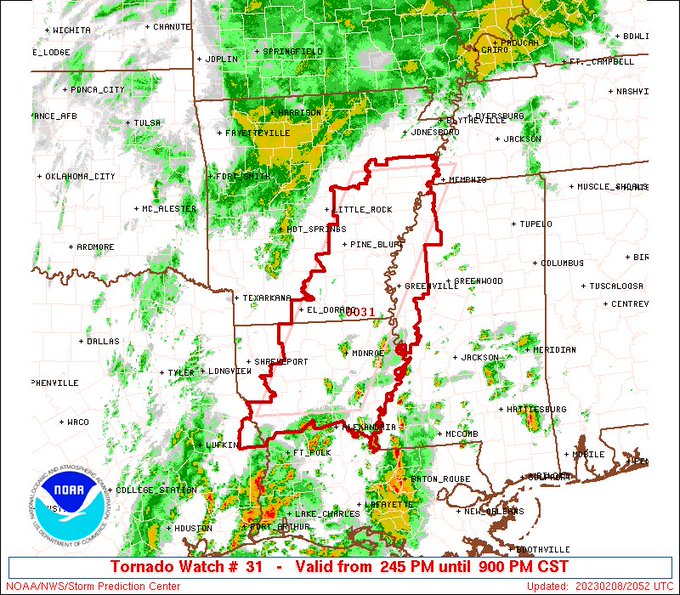
URGENT - IMMEDIATE BROADCAST REQUESTED
TORNADO WATCH NUMBER 31
NWS STORM PREDICTION CENTER NORMAN OK
245 PM CST WED FEB 8 2023
THE NWS STORM PREDICTION CENTER HAS ISSUED A
* TORNADO WATCH FOR PORTIONS OF
SOUTHEASTERN ARKANSAS ARKANSAS
NORTHERN LOUISIANA
WESTERN MISSISSIPPI
EASTERN TEXAS
* EFFECTIVE THIS WEDNESDAY AFTERNOON AND EVENING FROM 245 PM
UNTIL 900 PM CST.
* PRIMARY THREATS INCLUDE...
A FEW TORNADOES LIKELY WITH A COUPLE INTENSE TORNADOES POSSIBLE
SCATTERED DAMAGING WIND GUSTS TO 70 MPH LIKELY
SCATTERED LARGE HAIL EVENTS TO 1.5 INCHES IN DIAMETER POSSIBLE
SUMMARY...THUNDERSTORMS ARE EXPECTED TO INCREASE ACROSS THE REGION
LATE THIS AFTERNOON AND INTENSIFY THIS EVENING, WITH ENVIRONMENTAL
CONDITIONS BECOMING INCREASINGLY CONDUCIVE TO A RISK FOR TORNADOES.
NEAR-SURFACE WARMING AND MOISTENING, AS LOW-LEVEL VERTICAL SHEAR
INCREASES MORE SUBSTANTIALLY, COULD BECOME SUPPORTIVE OF A STRONG
TORNADO OR TWO, PARTICULARLY AFTER 6 PM CST.
What's the probs?
60/40What's the probs?
Lol sounds like a typical southern severe threat. Is the cell mergers due to lack of higher bulk shear and almost a non existent cap?complete mess, pretty much what i thought would happen. Keep an eye out for anything further west that has more spacing, but anything that starts to root is going to immediately go through cell mergers.

non existent capping inversion + no eml + plenty of WAA + synoptic forcing = high volume of general convection.Lol sounds like a typical southern severe threat. Is the cell mergers due to lack of higher bulk shear and almost a non existent cap?