
Navigation
Install the app
How to install the app on iOS
Follow along with the video below to see how to install our site as a web app on your home screen.
Note: This feature may not be available in some browsers.
More options
-
Welcome to TalkWeather! We see you lurking around TalkWeather! Take the extra step and join us today to view attachments, see less ads and maybe even join the discussion. CLICK TO JOIN TALKWEATHER
You are using an out of date browser. It may not display this or other websites correctly.
You should upgrade or use an alternative browser.
You should upgrade or use an alternative browser.
Severe WX February 8th - 12th deep south severe threat.
- Thread starter UncleJuJu98
- Start date
- Thread starter
- #102
Hrrr has a nasty storm in east missippi this evening.
- Thread starter
- #103
Perfect! Latest hrrr has a few isolated cells really taking advantage of that area tonightDay 1 1300z Outlook.
xJownage
Member
ENH for S MS, 10% nonhatch.
Honestly, I get the upgrade; the non-hatch seems to be because of the QLCS and overall shear for spinups rather than anything significantly supercellular. MS in general looks like a complete mess. It's going to be hard to get even semi-discrete structures as the forcing is fairly strong and the complete lack of EML will likely result in constant cell mergers and an inability for discrete supers to mature, exacerbated by dixie-typical meager lapse rates making overall maturation take a long time. QLCS tors, as usual, are at a decent risk just due to the general shear profiles, and I expect to see a few QLCS tors in MS given the overall kinematic profile, justifying the 10.
I'm much more bullish for a sigtor risk on the WF in Arkansas. I'm an ingredients guy when it comes to tornadoes, and any discrete structure that can get going near the WF is going to be very dangerous given a fairly strong kinematic environment and very potent low level instability; and a more discrete mode seems more likely there than in S MS.
- Thread starter
- #105
I think the guys at SPC may be worried about the mcs/ squall line out ahead of that, that would limit any real good threat. Hence why the SPC put the 10% in just the south central Mississippi region with less restriction of inflow. Granted probably lesser synoptic lift and wind shear though.ENH for S MS, 10% nonhatch.
Honestly, I get the upgrade; the non-hatch seems to be because of the QLCS and overall shear for spinups rather than anything significantly supercellular. MS in general looks like a complete mess. It's going to be hard to get even semi-discrete structures as the forcing is fairly strong and the complete lack of EML will likely result in constant cell mergers and an inability for discrete supers to mature, exacerbated by dixie-typical meager lapse rates making overall maturation take a long time. QLCS tors, as usual, are at a decent risk just due to the general shear profiles, and I expect to see a few QLCS tors in MS given the overall kinematic profile, justifying the 10.
I'm much more bullish for a sigtor risk on the WF in Arkansas. I'm an ingredients guy when it comes to tornadoes, and any discrete structure that can get going near the WF is going to be very dangerous given a fairly strong kinematic environment and very potent low level instability; and a more discrete mode seems more likely there than in S MS.

xJownage
Member
I mean, lower synoptic lift is more beneficial for tor risk in this case, given lower probabilities of crapvection.I think the guys at SPC may be worried about the mcs/ squall line out ahead of that, that would limit any real good threat. Hence why the SPC put the 10% in just the south central Mississippi region with less restriction of inflow. Granted probably lesser synoptic lift and wind shear though. View attachment 17630
I would caution you against looking at CAM solutions on the day of an event however. Observational verification is much better for forecasting events like these.
That being said, I'm not worried about more temporary restriction of inflow, rather i'm worried about supercells not having the time to mature before undergoing storm mergers. There's multiple failure modes potentially going on here, including the forecast SFC inversion.
If I see SFC temps overperforming this afternoon, my assessment will change pretty rapidly. Overperformance of SFC heating and WAA is exactly what made 1/12 such a sneaky major event.
- Thread starter
- #107
1/12 also overperformed on backing winds more than modeled. Good points thoughI mean, lower synoptic lift is more beneficial for tor risk in this case, given lower probabilities of crapvection.
I would caution you against looking at CAM solutions on the day of an event however. Observational verification is much better for forecasting events like these.
That being said, I'm not worried about more temporary restriction of inflow, rather i'm worried about supercells not having the time to mature before undergoing storm mergers. There's multiple failure modes potentially going on here, including the forecast SFC inversion.
If I see SFC temps overperforming this afternoon, my assessment will change pretty rapidly. Overperformance of SFC heating and WAA is exactly what made 1/12 such a sneaky major event.
xJownage
Member
To be fair, that was a function of stronger WAA than forecast, but that's neither here nor there lol. Basically, the enhanced strength of the low caused stronger WAA, which led to stronger instability and further backed winds than expected. This also alleviated the VB that was present in AL early in the risk area.1/12 also overperformed on backing winds more than modeled. Good points though
If you're looking at today and looking for potential oververification or uptrends, watch the low strength first. Other things to watch include SFC temps, SFC-3km lapse rates, and MLCAPE. Comparing them to CAM runs will give you a good idea of how today is going to perform compared to forecast and CAMs.
- Thread starter
- #109
Yeah the further this thing pushes into a nocturnal threat the less confident I am in surface lapse rates being adequate. I mentioned a day or two ago can't remember, that if this system is even just 4mb or so deeper the implications on threats could be heightened and how fast the thing drops in pressure leading to stronger WAA.To be fair, that was a function of stronger WAA than forecast, but that's neither here nor there lol. Basically, the enhanced strength of the low caused stronger WAA, which led to stronger instability and further backed winds than expected. This also alleviated the VB that was present in AL early in the risk area.
If you're looking at today and looking for potential oververification or uptrends, watch the low strength first. Other things to watch include SFC temps, SFC-3km lapse rates, and MLCAPE. Comparing them to CAM runs will give you a good idea of how today is going to perform compared to forecast and CAMs.
xJownage
Member
Ehhh, hesitate on that thinking. Due to dynamics and extremely low LCLs + deep moisture, poor LLLRs do NOT preclude tornadoes in dixie, even big ones. Even sub 6C LLLRs can support viotors. 3/25/21 is a good example of this. In fact, even if you look at the granddaddy of them all, 4/27, you'll see 6-6.5C lapse rates. You can get a pretty high end event despite poor LLLRs in dixie, and in fact LLLRs being too high can potentially be a failure mode (you're either introducing dry air in the boundary layer, or you'll end up with a complete convective mess).Yeah the further this thing pushes into a nocturnal threat the less confident I am in surface lapse rates being adequate. I mentioned a day or two ago can't remember, that if this system is even just 4mb or so deeper the implications on threats could be heightened and how fast the thing drops in pressure leading to stronger WAA.
For a little more insight, note that higher LCLs will make the LLLRs have more of an effect. This can sometimes happen when dry air aloft present in dixie setups mixes down towards the surface, which raises the LCL over forecast. This was specifically part of a combination of limiting factors on 11/29, for which you can read my analysis on here.
What poor LLLRs do is make the supercell maturation process take far longer than it would in the plains. This means that overall crapvection volume becomes far more important, and this is another reason that dixie sees so many events get limited by convective coverage.
- Thread starter
- #111
Enjoy your commentary and analysis @xJownage , many people don't go through with the time on explaining things, lol I love reading analysis helps me to fine tune my understand of weather.
xJownage
Member
My goal is to teach people. I was once a weenie (don't look at my really old post history) who knew very little. Through the kindness of several meteorologists and experienced chasers, I've learned a lot more. I like to pass that knowledge down where possible while continuing to learn more myself.Enjoy your commentary and analysis @xJownage , many people don't go through with the time on explaining things, lol I love reading analysis helps me to fine tune my understand of weather.
- Thread starter
- #113
Yeah, sadly a lot of the weather community more so points a finger of blasphemy without telling somebody where they went wrong on there forecast or analysis. Arcc is about the only real good person I've learned from on weather and he said he got a lot of his knowledge from long convos with Fred gossage.My goal is to teach people. I was once a weenie (don't look at my really old post history) who knew very little. Through the kindness of several meteorologists and experienced chasers, I've learned a lot more. I like to pass that knowledge down where possible while continuing to learn more myself.
You and Arcc and probably the two most informative posters I've seen.
xJownage
Member
I appreciate the compliment, I try my best. And yeah, the WX community in general can be very elitist and toxic, but that's a conversation for a different thread.Yeah, sadly a lot of the weather community more so points a finger of blasphemy without telling somebody where they went wrong on there forecast or analysis. Arcc is about the only real good person I've learned from on weather and he said he got a lot of his knowledge from long convos with Fred gossage.
You and Arcc and probably the two most informative posters I've seen.
CheeselandSkies
Member
Speaking of informative people, Trey G. has the video out:
- Thread starter
- #116
According to trey the sweet spot is from 3-6 o'clock in that enchanched with a decent bit of coverage of squall and possibly a couple supercells.
cincywx
Member
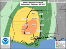
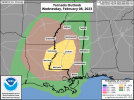
spc has added a hatched contour to the 10% tornado risk with the 1630z update:

Day 1 Convective Outlook
NWS Storm Prediction Center Norman OK
1027 AM CST Wed Feb 08 2023
Valid 081630Z - 091200Z
...THERE IS AN ENHANCED RISK OF SEVERE THUNDERSTORMS THIS EVENING
ACROSS PARTS OF EASTERN LOUISIANA...SOUTHEASTERN ARKANSAS...AND
WESTERN INTO CENTRAL MISSISSIPPI...
...SUMMARY...
Severe thunderstorms are expected to develop this afternoon into
tonight, mainly across parts of the lower into middle Mississippi
Valley. Some of these will be accompanied by a risk for tornadoes,
a couple of which could become strong this evening across parts of
eastern Louisiana and southeastern Arkansas into western and central
Mississippi.
...Synopsis...
The more prominent belt of split mid-latitude westerlies is
undergoing considerable amplification across the eastern Pacific
into western North America. This will continue through this period,
with mid-level ridging building inland of the Canadian and U.S.
Pacific coast by late tonight. As this occurs, a vigorous
downstream short wave trough is forecast to dig sharply along the
Rockies, with mid-level flow ahead of it trending southwesterly and
strengthening across the southern Great Plains through the Ohio
Valley.
A significant mid-level trough/elongating low is already beginning
to pivot east of the southern Rockies as it begins to interact with
a belt of westerlies emanating from the subtropical eastern Pacific.
The trough axis is likely to gradually take on an increasingly
negative tilt across Oklahoma and Texas during the day today, before
accelerating north-northeastward through the middle
Mississippi/lower Ohio Valley vicinity by 12Z Thursday. Models
continue to indicate that associated forcing for ascent will
contribute to significant surface cyclogenesis from near/northwest
of the Ark-La-Tex by late this afternoon into areas north-northeast
of the St. Louis area by the end of the period.
In the wake of a couple of significant recent cold intrusions,
boundary modification over the northwestern Gulf of Mexico is still
underway. Mid/upper 60s surface dew points have advected inland
within at least a shallow pre-cold frontal plume across Texas
coastal areas into portions of the Piney Woods. A somewhat more
substantive influx of Gulf moisture is forecast to overspread the
Louisiana coast through much of the lower Mississippi Valley later
today through tonight. Near the northwestern periphery of mid-level
subtropical ridging, centered and becoming a bit more prominent
across the Bahamas, mid/upper-levels are relatively warm, and lapse
rates might not become particularly steep. However, the development
of weak to moderate boundary-layer CAPE still appears probable
within the evolving warm sector, in the presence of strengthening
deep-layer shear which is expected to become sufficient for
organized convection, including supercells.
...Southeastern Great Plains into Mississippi Valley...
The primary mid-level trough may be preceded to its south and
southeast by one or two subtropical perturbations, and the influence
of associated forcing for ascent on thunderstorm development within
the plume of returning moisture, while the boundary-layer attempts
to destabilize inland of coastal areas, remains unclear.
At the present time, the low-level moisture return associated with
the stronger low-level flow (still around 40-50 kt around 850 mb) is
tending to be undercut by the eastward advancing cold front, to the
south of the developing surface low over northeast Texas.
Meanwhile, convection allowing models generally indicate that a
considerable amount of convection may commence in the destabilizing
warm sector, well ahead of the cold front, across portions of
Louisiana into Mississippi this afternoon. This would likely be
prior to substantive strengthening of the low-level wind fields and
associated hodographs, though the environment could be supportive of
at least weak updraft rotation.
Depending on the impact of earlier convective development, forcing
along and just ahead of the eastward advancing cold front likely
will become the focus for increasing vigorous thunderstorm
development late this afternoon and evening. This probably will
including one or two evolving lines, with supercells embedded within
and perhaps preceding it. Coupled with strengthening southerly 850
mb flow along a corridor near/east of the Mississippi River, as
surface cyclogenesis proceeds, a window of opportunity may develop
this evening for one or two sustained, long tracked supercells
capable of producing strong tornadoes.
The possible lingering influence of at least a shallow residual
stable surface-based layer results in more uncertainty concerning
severe weather potential closer to the track of the surface cyclone.
However, mid/upper forcing for ascent and deep-layer mean wind
fields/shear will be stronger across this region, and could
contribute to potential for damaging surface gusts and perhaps
tornadoes.
..Kerr/Supinie.. 02/08/2023
- Thread starter
- #118
That's impressive, I guess SPC is predicting possibility of significant tornadoes when that llj ramps up tonight.spc has added a hatched contour to the 10% tornado risk with the 1630z update:
Got the hatched area at least nearby the southeast Arkansas area where the better parameters are. @xJownage
xJownage
Member
Very well aligned with where the 576dm contour will be. Fred wins again lol.
SmokeEater
Member
As surface cyclogenesis proceeds, a window of opportunity may develop this evening for one or two sustained, long tracked supercells capable of producing strong tornadoes.That's impressive, I guess SPC is predicting possibility of significant tornadoes when that llj ramps up tonight.
Got the hatched area at least nearby the southeast Arkansas area where the better parameters are. @xJownage
Sent from my SM-S901U using Tapatalk