
I'll ask again, what on Earth was MEG doing with this survey?
Navigation
Install the app
How to install the app on iOS
Follow along with the video below to see how to install our site as a web app on your home screen.
Note: This feature may not be available in some browsers.
More options
-
Welcome to TalkWeather! We see you lurking around TalkWeather! Take the extra step and join us today to view attachments, see less ads and maybe even join the discussion. CLICK TO JOIN TALKWEATHER
You are using an out of date browser. It may not display this or other websites correctly.
You should upgrade or use an alternative browser.
You should upgrade or use an alternative browser.
Discussion of April 27, 2011 Outbreak
- Thread starter WesL
- Start date
-
- Tags
- 4/27 outbreak tw archive
CheeselandSkies
Member
In case anyone missed this: Great to hear Greg Forbes' perspective and awesome that he has contributed to Tornado Talk!
 www.tornadotalk.com
He did an excellent job that day, IMO. One of the few times in recent decades that TWC's coverage of a severe weather event has been *almost* as good as a local station's in terms of getting warnings for a resident of the affected area.
Remembering the Super Outbreak – Tornado Talk
He did an excellent job that day, IMO. One of the few times in recent decades that TWC's coverage of a severe weather event has been *almost* as good as a local station's in terms of getting warnings for a resident of the affected area.
@buckeye05 you should probably read that Houston/New Wren one. I'll be surprised if you don't have steam coming out of your ears by the end of it.
WIL9287
Member
That's what we were wondering. It seemed as though they just took the numbers from what the EMA offices were telling them, and that was it.I'll ask again, what on Earth was MEG doing with this survey?
Equus
Member
I ask 'what was MEG doing' in many contexts the last several years to be honest
CheeselandSkies
Member
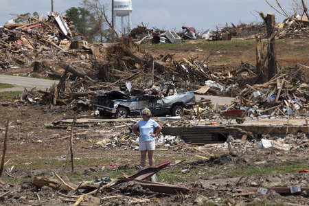
I went through my old photo stash and put up an article on what I saw from the house on 4/27 and some of the aftermath elsewhere a couple weeks later.

Tenth Anniversary of April 27, 2011 Super Outbreak: A Personal Photo Journal
Ten years ago today, the largest known tornado outbreak in recorded history ravaged the south, killing more than 300 people across multiple states. It was a truly horrifying day that will never be …walkercountytornadoes.wordpress.com
Thank you for sharing your photos and descriptions of some of the less well-covered damaged areas, especially eastern Walker County. You did for that area what that Tornado Talk article did for Houston/New Wren.
I'd call them out on Twitter, but I figure that'd be more appropriate for y'all to do if it was going to be done since you did the research.That's what we were wondering. It seemed as though they just took the numbers from what the EMA offices were telling them, and that was it.
Equus
Member
Hopefully Grazulis takes note, will be interested to see the description to that no doubt extraordinarily underrated tornado in the sigtor update.
CheeselandSkies
Member
@Equus Your photo of the cinder blocks that rained down into that interior hallway of Hackleburg High School is very sobering, since it would be a natural place to gather the students. During tornado drills when I was in school in the '90s, they usually had us go out in the hallways and "duck and cover" against the lockers. The decision to let schools out early that day undoubtedly saved many lives.
Equus
Member
Yeah it'd have probably been a massive tragedy especially in Hackleburg, that pile of blocks was nearly chest high in places. I'm sure there were injuries and fatalities that wouldn't have happened if the victim was at school or work, but that's concentrated death toll national tragedy right there.
SilentShadow87
Member
Well, at about this time exactly 10 years ago things were starting to heat up. Looking through the archive thread is especially interesting (and disturbing) on 4/27 every year...It's surreal to see that everyone knew it was going to be bad, but it's obvious that not even the top meteorologists at this time had any idea what was about to happen.
ARCC
Member
While looking for pictures the other day, I found these.
APRIL 27 2011 Tornado Outbreak | Robin Cooper Photography
APRIL 27 2011 Tornado Outbreak: Alabama Photographer Robin Cooper
www.robincooperphotography.com
Equus
Member
Looking at the loop... the Cullman supercell was first showing up as a few light reflectivity echoes over Pickens about now. It'd be tornado warned an hour later when it headed into Walker.
Can track along every five minutes with this
Can track along every five minutes with this
CheeselandSkies
Member
*STORM ALERT*
"It's two o'clock, I'm James Spann in the Weather Center with an update on the severe weather situation. First off, we still have this 'HIGH RISK' of severe weather, you all know by now this is relatively rare, a very substantial threat for much of north and central Alabama, and a new tornado watch has just been issued. Let's go right to the radar, and we'll kind of get you up to date on that. This new tornado watch will be in effect for basically all of our viewing area and most of Alabama until ten o' clock tonight, and this watch is a 'P.D.S.' watch, that means that this is a particularly dangerous situation and again, that means that we could see a few potentially violent, long-tracked tornadoes across the region this afternoon."
"It's two o'clock, I'm James Spann in the Weather Center with an update on the severe weather situation. First off, we still have this 'HIGH RISK' of severe weather, you all know by now this is relatively rare, a very substantial threat for much of north and central Alabama, and a new tornado watch has just been issued. Let's go right to the radar, and we'll kind of get you up to date on that. This new tornado watch will be in effect for basically all of our viewing area and most of Alabama until ten o' clock tonight, and this watch is a 'P.D.S.' watch, that means that this is a particularly dangerous situation and again, that means that we could see a few potentially violent, long-tracked tornadoes across the region this afternoon."
Equus
Member
Equus
Member
I'll never forget the moment here they stare at the 12.6 on the sig tor index in disbelief thinking it only went to ten, before the storm was even warned
Lol I’ll definitely have a look! I’m sure it’ll every bit as fascinating as it is infuriating@buckeye05 you should probably read that Houston/New Wren one. I'll be surprised if you don't have steam coming out of your ears by the end of it.

CheeselandSkies
Member
Jason Simpson, ten years ago: "Look at that. The funnel is getting tighter."
James Spann: I see it. Ok. Again...(gestures to funnel on chroma key wall)
Simpson: Let's get-let's get tighter in on that thing. I'm going to take the higher compression off so we can move faster-that's a tornado on, that's got to be on the ground, look at that.
Spann: We got a tornado down. This is a tornado emergency for the city of Cullman.
Simpson: I think, west Cullman, you are in most danger of this. Look, I can see the debris cloud at the bottom of it. That is west of downtown Cullman right now, so if you are in (mic cuts out) the northwest edge of Good Hope or in Cullman you need to be in a safe place immediately, we have a tornado live on the skycam.
Spann: Alright. Again, this is a tornado emergency for the city of Cullman at 2:46.
Bama Ravens
Member
Slightly off-topic, but did you ever get your video tapes of the 33/40 coverage back?
Equus
Member
I should have some news about that very soon, waiting for a confirmation of something this afternoon.Slightly off-topic, but did you ever get your video tapes of the 33/40 coverage back?