
Navigation
Install the app
How to install the app on iOS
Follow along with the video below to see how to install our site as a web app on your home screen.
Note: This feature may not be available in some browsers.
More options
-
Welcome to TalkWeather! We see you lurking around TalkWeather! Take the extra step and join us today to view attachments, see less ads and maybe even join the discussion. CLICK TO JOIN TALKWEATHER
You are using an out of date browser. It may not display this or other websites correctly.
You should upgrade or use an alternative browser.
You should upgrade or use an alternative browser.
Severe WX December 31, 2021 - January 1, 2022 Severe Threat
- Thread starter KevinH
- Start date
Chris3024
Member
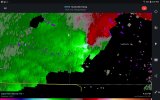
The storm in colbert county has taken off
NorthGaWeather
Member
Colbert and Limestone cells still seem too broad rotation wise for a warning. But that could change quickly as that outflow boundary is in that region. Colbert cell especially.
Fayetteville, TN cell is broadly rotating now. Looked great for a few scans.
Fayetteville, TN cell is broadly rotating now. Looked great for a few scans.
- Moderator
- #305
RadarScope is showing a TVS headed for Cherokee.
FEARLESS
Member
I sent warning out about it earlier on social mediaNo warning ...
CheeselandSkies
Member
I sent warning out about it earlier on social media
Unfortunately that won't cause the sirens to go off, or local TV mets to break into regular programming.
Equus
Member
Discrete Pickens cell has collapsed based on echo tops it looks like, LLJ kicking in soon but gotta get these storms rooted first and past the cap down this way before we get things cranking
Kragg
Member
Check that cell that’s over Philadelphia MS. It’s got a good inflow notch and is still growing on echoe topsDiscrete Pickens cell has collapsed based on echo tops it looks like, LLJ kicking in soon but gotta get these storms rooted first and past the cap down this way before we get things cranking
OHWX97
Member
Tornado warning issued for Columbus, MS.
Jetstream
Member
Tornado warning for the storm southeast of Starkville
CheeselandSkies
Member
Tornado warning issued for Columbus, MS.
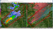
On the GR2AE maps, at least, it looks like two TORs practically on top of each other!
TCLwx
Member
Software error per Laubhan on WTVAWhat's the deal with the dual polygons?
Jetstream
Member
By looking at the counties mentioned, Noxubee county was mentioned in one of the warnings
bwalk
Member
Artesia, Ms storm is maintaining velocity couplet form (though weak to moderate)

TOR out for Franklin Co, TN:
793
WFUS54 KHUN 012342
TORHUN
TNC051-103-127-020000-
/O.NEW.KHUN.TO.W.0001.220101T2342Z-220102T0000Z/
BULLETIN - EAS ACTIVATION REQUESTED
Tornado Warning
National Weather Service Huntsville AL
542 PM CST Sat Jan 1 2022
The National Weather Service in Huntsville Alabama has issued a
* Tornado Warning for...
Moore County in Middle Tennessee...
Northeastern Lincoln County in Middle Tennessee...
Northern Franklin County in Middle Tennessee...
* Until 600 PM CST.
* At 541 PM CST, a severe thunderstorm capable of producing a tornado
was located near Lynchburg, moving east at 50 mph.
HAZARD...Tornado.
SOURCE...Radar indicated rotation.
IMPACT...Flying debris will be dangerous to those caught without
shelter. Mobile homes will be damaged or destroyed.
Damage to roofs, windows, and vehicles will occur. Tree
damage is likely.
* This dangerous storm will be near...
Tims Ford Lake around 550 PM CST.
Winchester and Estill Springs around 555 PM CST.
Decherd around 600 PM CST.
Other locations impacted by this tornadic thunderstorm include Lexie
Crossroads, Smithland, Woods Reservoir, Harmony, Arnold AFB, Hurdlow,
Lois, Alto, Booneville and Marble Hill.
PRECAUTIONARY/PREPAREDNESS ACTIONS...
TAKE COVER NOW! Move to a basement or an interior room on the lowest
floor of a sturdy building. Avoid windows. If you are outdoors, in a
mobile home, or in a vehicle, move to the closest substantial shelter
and protect yourself from flying debris.
&&
LAT...LON 3537 8626 3534 8624 3535 8622 3533 8620
3536 8617 3535 8616 3536 8616 3534 8603
3531 8600 3532 8598 3529 8592 3523 8588
3511 8640 3528 8648
TIME...MOT...LOC 2341Z 248DEG 44KT 3523 8634
TORNADO...RADAR INDICATED
MAX HAIL SIZE...<.75 IN
$$
RSB
Bama Ravens
Member
I’ve been wondering the same thing.What's the deal with the dual polygons?
The Bammer
Member
Starting to see lightning on some if these storms. Thoughts on if that means the cap is breaking?