• Welcome to TalkWeather!
    We see you lurking around TalkWeather! Take the extra step and join us today to view attachments, see less ads and maybe even join the discussion.
    CLICK TO JOIN TALKWEATHER

Severe WX December 31, 2021 - January 1, 2022 Severe Threat

Substantial lightning increase with activity near Vernon and along that line. 3KM NAM and HRRR show updraft helicity streak along it as it progresses northeastward to near Cullman/I-65 around midnight.
 
Last edited:
That cluster of storms just east of Jackson MS lit off as fast as anything I’ve seen today.

ETA: surface winds from SSW have noticeably increased in the last 5-10 minutes here on the Shelby/Jefferson county line.
 
Last edited:
There's been a tremendous amount of rain here, Reality is well outside of the estimated radar totals but it feels like we've been in 55+65dBz for at least an hour straight.

Screenshot_20220101-224422.png

I'm very surprised that my biggest concern is flash flooding vs tornadoes during this time of year, with these parameters in place. Definitely bring back some 2015 vibes for Madison County, AL.
 
Line is almost overhead and so far velocity signatures seem pretty tame, hopefully no spinups from this one; lotta lightning and wind to go though
 
Anybody watching the line just south of Scottsboro? Was that maybe a quick spin up? It was gone by the next scan.
 

Attachments

  • 4780570A-F213-4391-BA4B-A538FD78501D.png
    4780570A-F213-4391-BA4B-A538FD78501D.png
    338.1 KB · Views: 0
  • 6CB5DDED-B194-4276-ACC9-FE044F3716D8.png
    6CB5DDED-B194-4276-ACC9-FE044F3716D8.png
    462.2 KB · Views: 0
SPC issued another MD. They expect SVR risk to increase over the next few hours.

SUMMARY...RISK FOR SEVERE WEATHER -- INCLUDING POTENTIAL FOR A
COUPLE OF TORNADOES -- CONTINUES ACROSS THE WW AREAS, WITH SOME
INCREASE IN POTENTIAL EXPECTED OVER THE NEXT FEW HOURS.

DISCUSSION...LATEST WATER VAPOR LOOP SUGGESTS THAT MID- AND
UPPER-LEVEL HEIGHTS ARE GRADUALLY FALLING ACROSS THE CENTRAL GULF
COAST REGION AT THIS TIME, AS THE UPPER TROUGH CROSSING THE CENTRAL
AND SOUTHERN PLAINS ADVANCES.

SOUTH OF THE SOUTHWARD-MOVING SURFACE COLD FRONT -- NOW BISECTING
MISSISSIPPI FROM SOUTHWEST TO NORTHEAST AND EXTENDING ACROSS
NORTHERN ALABAMA AND EASTERN TENNESSEE, THE BOUNDARY LAYER REMAINS
QUITE MOIST. THIS -- COMBINED WITH THE MID-LEVEL ASCENT AIDING IN
SOME STEEPENING OF LAPSE RATES, IS HELPING TO MAINTAIN 500 TO 1000
J/KG MIXED-LAYER CAPE ACROSS THIS AREA PER RUC-BASED OBJECTIVE
ANALYSES. IN TANDEM WITH THE SUBTLY INCREASING ASCENT, AN UPTICK IN
CONVECTIVE COVERAGE/INTENSITY IS NOTED OVER THE PAST HOUR ACROSS THE
REGION, AND EXPECT THIS TREND TO CONTINUE OVER THE NEXT FEW HOURS
(IN LINE WITH HRRR AND OTHER RECENT CAM RUNS).

GIVEN THE VERY FAVORABLE BACKGROUND KINEMATIC ENVIRONMENT, RISK THAT
A FEW SEVERE/ROTATING STORMS RE-EMERGE REMAINS APPARENT. ALONG WITH
POTENTIAL FOR LOCALLY DAMAGING WINDS, A COUPLE OF TORNADOES REMAIN A
POSSIBILITY OVERNIGHT.
 
Line has hit here; not very much wind but lots of close lightning. Power is out; very close CG hit something very very nearby

Screenshot_20220101-233054-900.png
 
Last edited:
Can't believe I had a camera going to catch the leading edge at just the right time but hey I'm not complaining


Goodness, that was quite the bolt right there. Always best to paly it safe with lightning.
 
The time is now 12:16 CST. From what I can see Birmingham stayed above 70 all 24 hours NYD. I feel fairly certain we broke the record for warmest minimum temperature ever in meteorological winter!
 
Hey, all! Long time lurker here, and first time posting. I make this place one of my open browser tabs when severe weather might happen. I really appreciate y'all's (all y'all's) knowledge! I've seen so many spot-on observations/predictions here. I'm impressed every time I come here. I am also fascinated by mother nature and the things she can do.

I just want to say as an outsider that sometimes, it seems like people are hoping for tornadoes, and while that is awesome to behold, it sucks for the people under the gun/potentially under the gun/lost their house or worse. So, please keep that in mind. Sorry if I stepped on toes saying this.
 
The time is now 12:16 CST. From what I can see Birmingham stayed above 70 all 24 hours NYD. I feel fairly certain we broke the record for warmest minimum temperature ever in meteorological winter!
Haven't stepped outside in a few hours but the warmth and moisture has really been something else all day today.
 
Hey, all! Long time lurker here, and first time posting. I make this place one of my open browser tabs when severe weather might happen. I really appreciate y'all's (all y'all's) knowledge! I've seen so many spot-on observations/predictions here. I'm impressed every time I come here. I am also fascinated by mother nature and the things she can do.

I just want to say as an outsider that sometimes, it seems like people are hoping for tornadoes, and while that is awesome to behold, it sucks for the people under the gun/potentially under the gun/lost their house or worse. So, please keep that in mind. Sorry if I stepped on toes saying this.
I understand that balancing act well. Your amazement of the event cannot overtake your concerns for those impacted by the event. I cannot speak for others though, just myself.
 
FFC issued a SWS for Chattooga and Walker Counties over some storms that are showing some rotation. There seems to be a few kinks and separations in the line on radar.
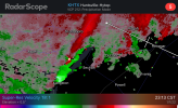
...A strong thunderstorm will impact portions of southeastern Walker
and northern Chattooga Counties through 200 AM EST...

At 135 AM EST, National Weather Service doppler radar indicated a
strong thunderstorms near Cloudland, or near Summerville, moving east
at 45 mph.

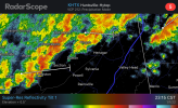
HAZARD...Increased chance of a brief tornado.

SOURCE...Radar indicated.

IMPACT...This storm has exhibited localized rotation. A brief
tornado could quickly form.

Locations impacted include...
Summerville, Trion, Menlo, Naomi, Center Post, Subligna, Suttles
Mill, Villanow and Cloudland.
 
Back
Top