
Equus
Member
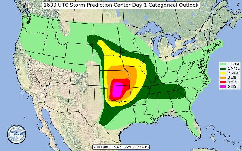
Day one is an enhanced. If trends continue, fully expect 5% at least to be pulled east.

Follow along with the video below to see how to install our site as a web app on your home screen.
Note: This feature may not be available in some browsers.
A few are broadly rotating too. As the LLJ ramps up, so will the mesocyclones.There are a few relatively discrete cells already popping in LA. They have that kind of “stretched” appearance though.
Given some of the shear profiles, these will be long tracking supercells. Probably cyclical in nature.Given the MCD, wonder if we get a hatch on the next outlook.
Given the MCD, wonder if we get a hatch on the next outlook.
Given sustained warm-sector supercells with little storm-scale
interference, such as progged by the sometimes overly aggressive
HRRR, such an environment can support significant/EF2+ tornadoes.
At this time, however, amount and longevity of relatively discrete
cells in the warm sector are still uncertain, especially given some
EML-driven capping, and flow aloft being largely parallel to the
primary corridor of forcing near the front. A hatched/significant
area may need to be added in an upcoming outlook if mesoscale
diagnostic trends and 12Z numerical guidance increase confidence in
multiple warm-sector supercells.
We've got two tornado warnings in Louisiana now.
Given potential for sustained warm-sector supercells, such as
progged by the HRRR, HRRR-P and WRF-ARW, such an environment will
support a risk for multiple significant tornadoes.