• Welcome to TalkWeather!
    We see you lurking around TalkWeather! Take the extra step and join us today to view attachments, see less ads and maybe even join the discussion.
    CLICK TO JOIN TALKWEATHER

Severe WX December 10 & 11, 2021 Severe Threat


Probably not a great sign when the dewpoint is 69 at Memphis at 1420z in December...
 
Fred and Richard….more thoughts?
 
From the latest SPC outlook:
"Regional 12z soundings revealed
65-70 F boundary-layer dewpoints in the warm sector this morning,
beneath midlevel lapse rates close to 7.5 C/km. Surface heating in
cloud breaks and continued warm/moist advection through the day will
result in destabilization and weakening of convective inhibition in
the open warm sector and along the cold front by this evening, when
storm initiation is expected."
 
Quite a few soundings I've popped from I-40 northward towards I-70 this evening have 0-1 km SRH exceeding 400 m2/s2 and 1000-2000 J/kg of MLCAPE. That is the type of combination that can easily yield strong/violent tornadoes with any supercells and embedded QLCS circulations. Actually a bit surprised they didn't expand the MDT northward towards I-70, especially closer to the warm front where the best wind fields are likely to exist.
 
Quite a few soundings I've popped from I-40 northward towards I-70 this evening have 0-1 km SRH exceeding 400 m2/s2 and 1000-2000 J/kg of MLCAPE. That is the type of combination that can easily yield strong/violent tornadoes with any supercells and embedded QLCS circulations. Actually a bit surprised they didn't expand the MDT northward towards I-70, especially closer to the warm front where the best wind fields are likely to exist.
I wonder if they worry about destabilization because I fully agree. Wouldn’t be surprised to see that expansion with one of the next two convective outlooks. Nonetheless, shaping up to be a dangerous evening and night for many.
 
Could this event be somewhat similar to 28–29 February 2017* in terms of results? That event featured a D1 15% TOR hatch and several EF2+ tornadoes.

*Included the Perryville, MO, EF4
 
This is Hindy, it won’t let me log in on my fb account.

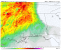
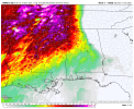
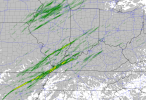
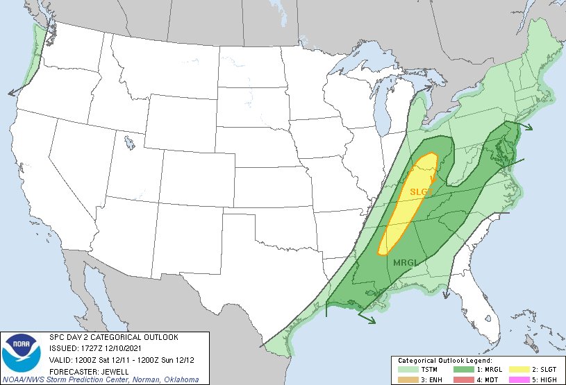
I really believe they should issue a mdt risk from eastern Missouri, north eastern ark, and the western 2/3 of Illinois
I'll check the FB feature.
 
The forcing that appears to be the focal point for supercell development later this afternoon and evening across northeast AR is just about to cross the southeast OK/southwest AR border.
 
Not great!

refcmp_uh001h.us_ov.png
 
16z HRRR Supercell and STP
 

Attachments

  • hrrr-alms-supercell_comp-9180800 (1).png
    hrrr-alms-supercell_comp-9180800 (1).png
    141.4 KB · Views: 0
  • hrrr-alms-sig_tor-9180800 (1).png
    hrrr-alms-sig_tor-9180800 (1).png
    153.7 KB · Views: 0
Yeah that's not too good. UH streaks raking over the Kentucky Bend region per the 16Z HRRR.
 

Attachments

  • 16z.png
    16z.png
    189.1 KB · Views: 0
The forcing that appears to be the focal point for supercell development later this afternoon and evening across northeast AR is just about to cross the southeast OK/southwest AR border.
The HRRR’s simulated reflectivity shows deeper returns as early as 2pm just southwest of Little Rock, AR, but maturity looks to take hold by 4pm and later across the moderate risk areas.
 
Newest D2 update from SPC expands the SLGT southwards.
FGQ2aizVIAMZtwM
 
Back
Top