• Welcome to TalkWeather!
    We see you lurking around TalkWeather! Take the extra step and join us today to view attachments, see less ads and maybe even join the discussion.
    CLICK TO JOIN TALKWEATHER

Severe WX December 10 & 11, 2021 Severe Threat

Kory

Member
Messages
4,928
Reaction score
2,119
Location
Tuscaloosa, Alabama
I know everyone's eyes are on the deep south for this one, but I do have some concerns for my own backyard overnight tomorrow. This one is absolutely screaming "Strongly forced line of gusty low-topped showers/storms with hard to warn for QLCS spinups" for my area. That type of thing is not uncommon at all for SW OH for late season severe. I'm concerned about a repeat of the 2014 Vandalia, OH EF1. Similar kind of setup, and that one ended up injuring quite a few people when it blew out the windows of a restaurant.
Yep, this has the feel to me that the action will be weighted toward the northern end of the outlooked area.
 

Kory

Member
Messages
4,928
Reaction score
2,119
Location
Tuscaloosa, Alabama
Latest HRRR coming in with CAD wedge in NE AL holding on for most of the day tomorrow. Odd considering there is no precip reinforcing it and deep southerly flow just to the west of it.
 

Kory

Member
Messages
4,928
Reaction score
2,119
Location
Tuscaloosa, Alabama
Yep, this has the feel to me that the action will be weighted toward the northern end of the outlooked area.
And the HRRR likes this idea still. Some long tracking cells from IL/IN/OH. Edit: some of the southern cells look to take off across MS deep into the night.

I’m taking away from this run of the HRRR that this will not be a fully congealed QLCS. It’ll be somewhat cellular.
 

akt1985

Member
Messages
1,020
Reaction score
538
Location
Madison, Alabama
Does anyone see any differences about how the public is reacting to a late night/early morning event heading into a weekend vs. a nocturnal/early morning event that happens in the middle of the work week?
 
Messages
148
Reaction score
210
Location
Trussville
To me, this is an interesting system. Very rare you see supercells in late fall after midnight in December. I’m wondering if the qlcs will be broken and those will produce tornadoes for a short time. I’m interested to see if the cells will pop up and turn into supercells ahead of the line or if they will have trouble rotating like I’ve seen many times. This system is going to be challenging for sure
 

TH2002

Member
Sustaining Member
Messages
3,173
Reaction score
4,815
Location
California, United States
Special Affiliations
  1. SKYWARN® Volunteer
Took note the SPC has finally sounded the alarm on this one and the GFS model in SCP mode, while still not screaming "MAJOR TORNADO OUTBREAK INCOMING" does now show a threat for a few strong tornadoes in the mid to NE MS area. I am beginning to wonder if the SPC will issue a small Moderate Risk area along with a 15% tornado area stretching from about mid MS through western TN where updraft helicity appears particularly favorable.
 
Messages
1,071
Reaction score
1,313
Location
jackson tennessee
Special Affiliations
  1. SKYWARN® Volunteer
Took note the SPC has finally sounded the alarm on this one and the GFS model in SCP mode, while still not screaming "MAJOR TORNADO OUTBREAK INCOMING" does now show a threat for a few strong tornadoes in the mid to NE MS area. I am beginning to wonder if the SPC will issue a small Moderate Risk area along with a 15% tornado area stretching from about mid MS through western TN where updraft helicity appears particularly favorable.
That’s my exact thoughts be honest
 

andyhb

Member
Messages
1,094
Reaction score
3,010
Location
Norman, OK
...Lower/Mid Mississippi Valley to the lower Ohio/Tennessee Valley
region...

Strong upper trough will progress across the Rockies into the Plains
by 11/00z then into the mid/upper MS Valley by the end of the period
as an intense 500mb speed max (100-110kt) translates into IL late.
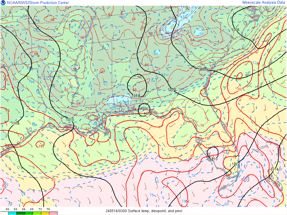
In response to this feature a surface low will deepen as it tracks
from southern KS to north of CHI by 11/06z then into northern lower
MI by daybreak Saturday. Severe thunderstorms are expected to
develop ahead of this strongly dynamic trough. Serious consideration
was given to higher severe probabilities along the MS delta region
of eastern AR into the lower OH River valley. Despite the nocturnal
initiation, strong tornadoes are possible with supercells Friday
night.


Southwesterly LLJ is expected to increase across eastern TX/lower MS
early in the period. This southerly branch of the LLJ will encourage
higher-quality boundary-layer air mass to advance north into the mid
MS Valley ahead of the surging cold front. Early this morning, lower
70s surface dew points are noted as far north as PSN to IER over
eastern TX/LA with lower 60s dew points into central AR. There is
little reason to doubt moisture will advance into MO/IL ahead of the
front as capping will prevent appreciable convection until mostly
after sunset. Latest model guidance suggests moisture
advection/cooling profiles aloft will result in destabilization
ahead of the surface low such that surface-based parcels should
become buoyant by 11/02-03z across MO. There is great disparity
among the latest HREF regarding timing/spatial distribution of
convection during the initiation phase after sunset. Based on
forecast soundings have opted to increase severe probabilities
farther west across the warm sector ahead of the surface front in
MO. Latest thinking is scattered supercells could develop by 03z
then track northeast within a very strongly sheared environment.
With thunderstorms not expected to develop until after dark diurnal
heating will not contribute appreciably to buoyancy across this
region. Even so, parameter space appears very favorable for
supercells, and with dew points expected to rise into the lower 60s,
a few strong, longer-lived tornadoes seem plausible.
Quite a strongly worded discussion in the newest D1 outlook, including mention of a possible upgrade to MDT risk later in the forecast cycle.
 
Messages
1,071
Reaction score
1,313
Location
jackson tennessee
Special Affiliations
  1. SKYWARN® Volunteer
That has to be one largest enhanced outlooks area I have ever seen. Definitely room to upgrade to moderate, some shorter range models picking up more discrete super cells pretty far out ahead of the cold front . Suspect a upgrade is coming later .
 

Richardjacks

Member
Meteorologist
Messages
1,161
Reaction score
1,331
Location
Atop Red Mountain Birmingham, Al
For Alabama, I am trying to figure out the eastward limit to severe storms today. I see the Northwest corner seeing a tornado threat, but I wondering if it may actually be a little further east during the afternoon hours. In looking at the overnight models, it looks like the activity wanes and pulls further back west tonight, then advances eastward tomorrow morning with the pre-frontal trough.

All of this to say, I am not 100% sure the SPC has a good handle on how far east the storms will erupt this afternoon. I do think they will be west of I-65, but probably east of the slight risk line. The low level shear is a bit higher than I would expect to be so far downstream from the trough...several models are showing a low level wind shear maximum passing through north and central Alabama late afternoon, while some storms develop. This appears to be happening as the 2 troughs phase...and happening while we have the highest instability of the day. Still not convinced storms will pop that far east then, but if they do....
 
Last edited:

Kory

Member
Messages
4,928
Reaction score
2,119
Location
Tuscaloosa, Alabama
HRRR continues to show the main focus for higher tornado/severe threat is the northern portion of the outlooked area. Southern portion is rather quiet if it is to be believed.
 
Messages
1,071
Reaction score
1,313
Location
jackson tennessee
Special Affiliations
  1. SKYWARN® Volunteer
On latest satellite imagery, you can see the few breaks in cloud s over the miss delta region ,that’s indicates surging dew point s are starting slowly move north …
 

Richardjacks

Member
Meteorologist
Messages
1,161
Reaction score
1,331
Location
Atop Red Mountain Birmingham, Al
strong moisture return for mid December!
ttd.gif
 

andyhb

Member
Messages
1,094
Reaction score
3,010
Location
Norman, OK
Low-level flow across the warm sector in this morning's model runs is almost unanimously more backed than some of the earlier guidance was suggesting, which would raise the tornado threat considerably. Given the idea of multiple warm sector supercells and QLCS potential + record levels of moisture content in the boundary layer, I think there's a good chance this gets upgraded to a MDT risk across the Mid MS Valley.
 
Back
Top