
Starting to get into that timeframe now, because of gearing up at the station, that I will be checking in less frequently the next few days. I see the Euro continues the trend toward a more neutral trough axis as we head toward midnight Friday night onward, and there's more subtle curvature in the base. This will always be capped by the fact that it's a trough sliding across the top of a ridge. That means things are being squeezed and you don't have as much cyclonic vorticity advection at the base. However, we've already discussed at length about how that only limits this so much, and is very far away from actually reducing the threat so that it's not appreciable and potentially significant. We're about to get this into most of the mesoscale models. I can see already that most of them are underdoing the warm air and moisture advection, just like they did with the Sunday/Monday system. The same models that, 48-60 hrs out, told me west central and northwest AL wouldn't get out of the 50s on Sunday when we hit 73 at MSL and 76 at TCL are delaying the morning moisture return. Surprise surprise. The Euro maintains the signal for evening discrete activity with that lead subtle disturbance, and is now trending stronger with the stuff after midnight into Saturday morning. The WRF-FV3 now has through 6pm Friday within its range, as did the 6z run of the Baron 3k, and both were developing discrete stuff in north MS/west TN by sunset Friday evening. I'm not ready to sound alarms on the tornado threat publicly until we get this deeper into mesoscale data, but when we look at that mesoscale data, we're going to need to make sure it is properly accounting for the speed of moisture return and warm air advection Friday, and that it does not erroneously decouple the boundary layer Friday overnight.
Navigation
Install the app
How to install the app on iOS
Follow along with the video below to see how to install our site as a web app on your home screen.
Note: This feature may not be available in some browsers.
More options
-
Welcome to TalkWeather! We see you lurking around TalkWeather! Take the extra step and join us today to view attachments, see less ads and maybe even join the discussion. CLICK TO JOIN TALKWEATHER
You are using an out of date browser. It may not display this or other websites correctly.
You should upgrade or use an alternative browser.
You should upgrade or use an alternative browser.
Severe WX December 10 & 11, 2021 Severe Threat
- Thread starter Richardjacks
- Start date
The steady trend I've seen today, with Euro and ICON initially leading the way on this yesterday, followed closely by Canadian, and finally the GFS, NAM, and GFS ensembles picking up on it this afternoon.... is that the trough doesn't really stay positive tilt. It gets increasingly neutral to slightly negatively tilted overnight Friday into Saturday morning. Our main limiting factor is how the trough slides across the ridge and how that flattens the ascent some at the base. But as we've talked about, there are smaller scale mechanisms that can overcome that.
Just going to silently leave this here...

KevinH
Member
Ummmm Wow!Soooooooo…..
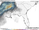
Rather large ENH/10% hatched tornado risk in the newest D2 outlook from SPC, highlighting the potential for strong nocturnal tornadoes across the Mid South and Lower MS Valley.
Confidence has increased in a more favorable corridor for organized severe thunderstorms Friday night into early Saturday morning from roughly the vicinity of the MS River in eastern AR and northern MS northward into parts of the lower OH Valley. Across this region, the best overlap of sufficient instability, strong low-level and deep-layer shear, and a potentially favorable supercell mode may overlap for several hours (generally around 03-09Z). Have therefore increased severe wind and tornado probabilities across this region and have introduced and Enhanced Risk. Various forecast soundings from the 00Z NAM across this region show around 1000-1500 J/kg of MLCAPE, and effective SRH in excess of 300 m2/s2. This suggests some potential for nocturnal strong tornadoes.
Casuarina Head
Member
The ML trough looks to be a bit narrower and more positively tilted on the latest 00Z ECMWF through 48h. Also, LL flow looks to be more meridional vs. H5 vectors across the prefrontal warm sector, at least in part. The surface low itself looks to be more “strung-out” from NE to SW. A north-to-south orientation would be more favourable for enlarged low-level hodographs and enhanced SRH over the prefrontal warm sector, owing to the greater possibility of secondary low formation. The latest 00Z run seems to be trending away from the secondary low as a possibility. I think this reduces the threat of significant tornadoes in associated with discrete modality, but there is a risk of a few strong QLCS spin-ups along the front during the overnight hours.
tennessee storm chaser
Member
- Messages
- 1,877
- Reaction score
- 4,283
- Location
- jackson tennessee
- Special Affiliations
- SKYWARN® Volunteer
Going wait see how 12z suits follow today before I snooze on this. Looks like a classic winter nocturnal tornado setup for midsouth area. Instability wouldn’t shock me if it’s slightly underdone , though 1000 to 1500 cape is Plenty for a winter cold season severe threat plus throw in the lower level jet kicks in over night , think there some concern . Depends how 12z suits go today course overnight 0z and short range models go , an area to up grade moderate wouldn’t surprise me by tomorrow mornings outlook . SpcThe ML trough looks to be a bit narrower and more positively tilted on the latest 00Z ECMWF through 48h. Also, LL flow looks to be more meridional vs. H5 vectors across the prefrontal warm sector, at least in part. The surface low itself looks to be more “strung-out” from NE to SW. A north-to-south orientation would be more favourable for enlarged low-level hodographs and enhanced SRH over the prefrontal warm sector, owing to the greater possibility of secondary low formation. The latest 00Z run seems to be trending away from the secondary low as a possibility. I think this reduces the threat of significant tornadoes in associated with discrete modality, but there is a risk of a few strong QLCS spin-ups along the front during the overnight hours.
Kory
Member
The latest couple iterations of the long range HRRR have not been impressive with any of the UH streaks in the core of the outlooked area. However it has locked in on Indiana/Illinois/Michigan/Ohio.
chasestormz39
Member
I've noticed that too. Even up to Lincoln/Bloomington/Champaign in IL. Will depend on how much instability can be realized that far north and I have my suspicions but certainly something to watch for anyone on the northern fridge of the risk area.The latest couple iterations of the long range HRRR have not been impressive with any of the UH streaks in the core of the outlooked area. However it has locked in on Indiana/Illinois/Michigan/Ohio.
tennessee storm chaser
Member
- Messages
- 1,877
- Reaction score
- 4,283
- Location
- jackson tennessee
- Special Affiliations
- SKYWARN® Volunteer
Personally not buying that just yet. Instability doesn’t look very impressive that far north be honest . One thing I see could be problem further north would be a triple point threat we’re that area set us at still question , but feel it will be south of Michigan .I've noticed that too. Even up to Lincoln/Bloomington/Champaign in IL. Will depend on how much instability can be realized that far north and I have my suspicions but certainly something to watch for anyone on the northern fridge of the risk area.
Kory
Member
NSSL/ARW doesn’t convect until way after dark. ARW is a bit more bullish with UH streaks. NSSL goes linear/QLCS pretty fast after convection initiation where ARW is a bit more cellular but does go more linear with embedded supercells over time.
Kory
Member
CAMs get surface destabilization quite far north after dark. The fact that there’s no convective initiation until well after dark will aid in getting better instability quite father north.Personally not buying that just yet. Instability doesn’t look very impressive that far north be honest . One thing I see could be problem further north would be a triple point threat we’re that area set us at still question , but feel it will be south of Michigan .
Kory
Member
It’ll be interesting to watch the surface temp trends across the CAMs today. Judging based off the last few days and today, they’re running about 4-5 degrees too cool. Extrapolate that out to tomorrow and you’ll get mid to upper 70s for highs across southern 2/3rds of MS/AL and mid 70s into West TN. That is an important factor to keep in the back of your head…especially with the CAMs not convecting during peak heating.
warneagle
Member
Yeah the 3km NAM keeps things capped until well after dark (e.g. at Memphis it doesn't really erode the cap until after 02z), although as Kory noted it may be underestimating the max temp (only gets to 71 at Memphis when it could probably get to 74-75 irl), so you have to take it with a grain of salt.
I have to say that the 3km NAM in particular doesn't seem overly impressed with this threat, especially in the lower MS valley, where it never really initiates deep sustained convection and the UH streaks are essentially non-existent. The only one that really says "potential outbreak" is the HRW-FV3, which has a broken line of supercells with substantial UH vs. most of the other HRWs, which go linear relatively quickly. I'm not going to pretend to understand the differences between the various HRW models, so maybe someone smarter than me can explain why that is.
I have to say that the 3km NAM in particular doesn't seem overly impressed with this threat, especially in the lower MS valley, where it never really initiates deep sustained convection and the UH streaks are essentially non-existent. The only one that really says "potential outbreak" is the HRW-FV3, which has a broken line of supercells with substantial UH vs. most of the other HRWs, which go linear relatively quickly. I'm not going to pretend to understand the differences between the various HRW models, so maybe someone smarter than me can explain why that is.
The morning run of the Baron 3k model had an unsettling trend. As the developing QLCS from west TN and northwest MS approached the U.S. 45 corridor, it started evolving the band back into full-on supercells... not supercells embedded in a QLCS... but supercells. It kept at least a semi-cellular look all the way across I-65. We've seen this evolution before, where deep-layer shear increases and causes a QLCS or messy organization to evolve back into supercells, even after a QLCS originally solidifies. Evansville IN November 2005, the predawn AL part of Super Tuesday 2008, and Center Point AL in January 2012 are a few examples. This would not only increase the long-track type tornado threat, but increase it for middle Tennessee and north/northwest Alabama. And note, this is completely without even worrying about or considering any type of evening warm sector initiation that is still in question.


One other thing you have to be super cautious about with the NAM is that the 12k NAM's convective parameterization scheme is specifically designed to not even initiate convection in environments with dry mid-level air. Rich Thomspon talked about this in his tornado forecasting video series. And guess what you have in significant severe environments when there is the EML that you desperately need for the major severe? Mid-level dry air. Now, we're talking about the 3k NAM... but the 3k NAM isn't fully stand-alone. The two are linked, and although the 3k NAM is a CAM, that issue trickles down.Yeah the 3km NAM keeps things capped until well after dark (e.g. at Memphis it doesn't really erode the cap until after 02z), although as Kory noted it may be underestimating the max temp (only gets to 71 at Memphis when it could probably get to 74-75 irl), so you have to take it with a grain of salt.
I have to say that the 3km NAM in particular doesn't seem overly impressed with this threat, especially in the lower MS valley, where it never really initiates deep sustained convection and the UH streaks are essentially non-existent. The only one that really says "potential outbreak" is the HRW-FV3, which has a broken line of supercells with substantial UH vs. most of the other HRWs, which go linear relatively quickly. I'm not going to pretend to understand the differences between the various HRW models, so maybe someone smarter than me can explain why that is.
- Thread starter
- #78
Fred, I believe the instability will be high enough to support what is shown, but I am questioning the reason for the storm mode change. Does the Baron show a reason for higher critical angle or low level shear? Something like that must be happening for that sort of change.
We don't get that kind of detail with the Baron 3k, but in previous cases it has happened, it's been because of either a magnitude increase or a vector veer of the deep-layer shear. Looking at the WRF-FV3 that has the same QLCS evolution, it has very WSW 0-6 km shear vectors as the QLCS approaches and crosses. Interestingly, so does the 3k NAM, and even with a slower QLCS timing, it's very much not a solid line either. Even the ARW and HRRR are broken/cellular with that prefrontal band/"QLCS" as it comes across. It's only the NSSL version of the WRF that I see that has bow echoes and a cold-pool driven type "line".Fred, I believe the instability will be high enough to support what is shown, but I am questioning the reason for the storm mode change. Does the Baron show a reason for higher critical angle or low level shear? Something like that must be happening for that sort of change.
Follow-up: ARW and HRRR are a little more veered with the 0-6 km vectors as well. It's the NSSL WRF that is most line-parallel with the vectors.
I know everyone's eyes are on the deep south for this one, but I do have some concerns for my own backyard overnight tomorrow. This one is absolutely screaming "Strongly forced line of gusty low-topped showers/storms with hard to warn for QLCS spinups" for my area. That type of thing is not uncommon at all for SW OH for late season severe. I'm concerned about a repeat of the 2014 Vandalia, OH EF1. Similar kind of setup, and that one ended up injuring quite a few people when it blew out the windows of a restaurant.